File:TV-introduction-world-map.svg
跳转到导航
跳转到搜索

此SVG文件的PNG预览的大小:800 × 411像素。 其他分辨率:320 × 164像素 | 640 × 329像素 | 1,024 × 526像素 | 1,280 × 657像素 | 2,560 × 1,314像素 | 863 × 443像素。
原始文件 (SVG文件,尺寸为863 × 443像素,文件大小:1.59 MB)
说明
说明
添加一行文字以描述该文件所表现的内容
| 描述 |
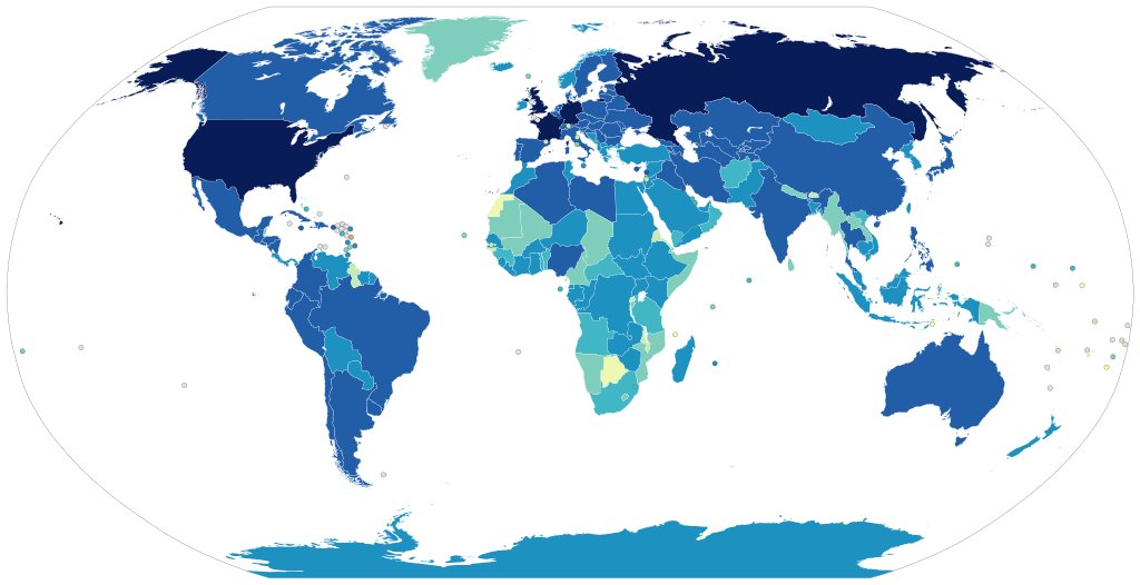
1939 and before
1940 to 1949
1950 to 1959
1960 to 1969
1970 to 1979
1980 to 1989
1990 to 1999
2000 and after
No television
No data |
||
| 日期 | |||
| 来源 | 自己的作品, using en:Image:BlankMap-World6.svg, with data from de:Liste der Länder nach Jahr der Einführung des Fernsehens. See there for the sources. | ||
| 作者 | User:Laydan Mortensen | ||
| 授权 (二次使用本文件) |
|
文件历史
点击某个日期/时间查看对应时刻的文件。
| 日期/时间 | 缩略图 | 大小 | 用户 | 备注 | |
|---|---|---|---|---|---|
| 当前 | 2021年11月10日 (三) 18:45 | | 863 × 443(1.59 MB) | AngelChavezCo(留言 | 贡献) | Television in El Salvador started in 1956. |
| 2018年4月14日 (六) 05:18 |  | 863 × 443(1.59 MB) | Howpper(留言 | 贡献) | Updated Western Sahara (sourced on article); Antarctica has had television since the 60's: https://books.google.com/books?id=L_L_VdtSxhcC&q=antarctica+television&dq=antarctica+television&hl=en&sa=X&ved=0ahUKEwibocOZgLnaAhUh3YMKHWcUA70Q6AEIMDAC http://java-tv.wikifoundry.com/page/Antarctica+Television+%281966-Present%29 | |
| 2013年5月9日 (四) 18:24 |  | 863 × 443(1.59 MB) | Fry1989(留言 | 贡献) | per talk | |
| 2013年5月9日 (四) 15:58 |  | 863 × 443(1.55 MB) | Antemister(留言 | 贡献) | see talk page | |
| 2013年4月27日 (六) 01:15 |  | 863 × 443(1.59 MB) | Fry1989(留言 | 贡献) | South Sudan makes no sense as 2000s or later, they would have had television at the same time as Sudan as they were one country at the time | |
| 2013年4月26日 (五) 22:38 |  | 863 × 443(1.55 MB) | Dewclouds(留言 | 贡献) | Edited Saudi-Yemen border, changed colour for no television, fixed 1990s/2000s colour error. | |
| 2013年4月25日 (四) 07:18 |  | 863 × 443(1.55 MB) | Dewclouds(留言 | 贡献) | New colour palette. | |
| 2013年4月24日 (三) 06:07 |  | 863 × 443(1.54 MB) | Dewclouds(留言 | 贡献) | New gradient colour scheme -- kindly ignore the last version, please. | |
| 2013年4月24日 (三) 05:34 |  | 863 × 443(1.54 MB) | Dewclouds(留言 | 贡献) | New version with data from de:Liste der Länder nach Jahr der Einführung des Fernsehens. | |
| 2012年9月29日 (六) 08:35 |  | 940 × 477(862 KB) | Lcmortensen(留言 | 贡献) | Map recoloured to prevent clashing green colours and reduce red-green colour blindness. Still need to double check countries are the right colour per current data. |
您不可以覆盖此文件。
文件用途
以下3个页面使用本文件:
全域文件用途
以下其他wiki使用此文件:
- ba.wikipedia.org上的用途
- be-tarask.wikipedia.org上的用途
- de.wikipedia.org上的用途
- en.wikipedia.org上的用途
- en.wikiquote.org上的用途
- es.wikipedia.org上的用途
- et.wikipedia.org上的用途
- fa.wikipedia.org上的用途
- fiu-vro.wikipedia.org上的用途
- fi.wikipedia.org上的用途
- id.wikipedia.org上的用途
- ko.wikipedia.org上的用途
- ms.wikipedia.org上的用途
- pnb.wikipedia.org上的用途
- pt.wikipedia.org上的用途
- ro.wikipedia.org上的用途
- ru.wikipedia.org上的用途
- tt.wikipedia.org上的用途
- ug.wikipedia.org上的用途
- uk.wikipedia.org上的用途
- ur.wikipedia.org上的用途
- vep.wikipedia.org上的用途
- zh.wikipedia.org上的用途