File:The Ancient Tegesta, now Promontory of East Florida. LOC 73694436.tif
Jump to navigation
Jump to search
Size of this JPG preview of this TIF file: 800 × 515 pixels. Other resolutions: 320 × 206 pixels | 640 × 412 pixels | 1,024 × 660 pixels | 1,280 × 825 pixels | 2,560 × 1,650 pixels | 6,228 × 4,013 pixels.
Original file (6,228 × 4,013 pixels, file size: 71.51 MB, MIME type: image/tiff)
Captions
Captions
Add a one-line explanation of what this file represents
Summary
[edit]| Description |
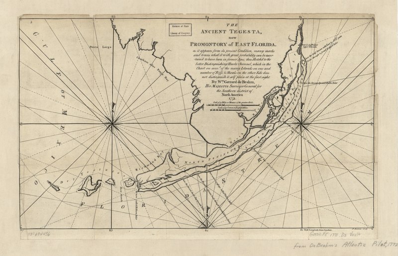
English: Scale ca. 1:700,000. "As it appears from its present condition, many marks and traces, what it with great probability can be ascertain'd to have been in former ages; thus sketch'd to the better distinguishing Hawke Channel, which in the chart on accot. of the many islands on one and number of riffs & shoals on the other side, does not distinguis'h itself plain at the first sight." From the author's The Atlantic pilot. 1772. LC Maps of North America, 1750-1789, 1627 Available also through the Library of Congress Web site as a raster image. Vault AACR2 |
||
| Title | The Ancient Tegesta, now Promontory of East Florida. | ||
| Shelf ID | G3932.F5 1771 .D3 | ||
| Date | |||
| Source | https://www.loc.gov/item/73694436/ | ||
| Author | De Brahm, John Gerar William; Andrews, Peter | ||
| Permission (Reusing this file) |
|
||
| Other versions |
|
||
| Location | United States · Florida · Florida Keys | ||
| Part of | Military Battles And Campaigns · American Memory · Catalog · Geography And Map Division · American Revolution And Its Era: Maps And Charts Of North America And The West Indies, 1750-1789 | ||
| Subject | Florida Keys (Fla.) · Florida · United States · Maps · Early Works To 1800 · Florida Keys |


Licensing
[edit]|
This is a faithful photographic reproduction of a two-dimensional, public domain work of art. The work of art itself is in the public domain for the following reason:
The official position taken by the Wikimedia Foundation is that "faithful reproductions of two-dimensional public domain works of art are public domain".
This photographic reproduction is therefore also considered to be in the public domain in the United States. In other jurisdictions, re-use of this content may be restricted; see Reuse of PD-Art photographs for details. | ||||
File history
Click on a date/time to view the file as it appeared at that time.
| Date/Time | Thumbnail | Dimensions | User | Comment | |
|---|---|---|---|---|---|
| current | 00:31, 27 May 2018 |  | 6,228 × 4,013 (71.51 MB) | Fæ (talk | contribs) | LOC Maps https://www.loc.gov/item/73694436/ #2241 |
You cannot overwrite this file.
File usage on Commons
The following page uses this file: