File:The Ball (formerly Ball Inn), 287 Darnall Road, Darnall - geograph.org.uk - 1249308.jpg
Jump to navigation
Jump to search
Size of this preview: 447 × 600 pixels. Other resolutions: 179 × 240 pixels | 477 × 640 pixels.
Original file (477 × 640 pixels, file size: 96 KB, MIME type: image/jpeg)
Captions
Captions
Add a one-line explanation of what this file represents
Summary
[edit]| Description |
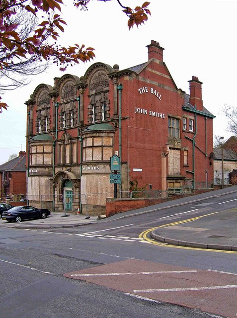
English: The Ball (formerly Ball Inn), 287 Darnall Road, Darnall This closed public house is on the corner of Darnall Road and Basford Street. In its prime this unusual building was probably very impressive, but sadly today (April 2009) it is boarded up. Above the central second floor window are the words "Rebuilt 1904. Ball Inn". Above the windows to the left and right of this the wording is: "John Smith's Tadcaster Ales". In its Victorian heyday the brewery was renowned for its ales, but later it became just another big brewery brand.
The area around this pub has changed enormously with industries and much of the population disappearing. Although many pubs have survived in the area, The Ball has been one of the casualties. This link shows a photograph of the pub some years ago: http://www.sheffieldpubs.fsnet.co.uk/Business/pubs/balldar.htm |
| Date | |
| Source | From geograph.org.uk |
| Author | P L Chadwick |
| Attribution (required by the license) | P L Chadwick / The Ball (formerly Ball Inn), 287 Darnall Road, Darnall / |
| Camera location | | View this and other nearby images on: OpenStreetMap |
|---|
| Object location | | View this and other nearby images on: OpenStreetMap |
|---|
Licensing
[edit]
|
This image was taken from the Geograph project collection. See this photograph's page on the Geograph website for the photographer's contact details. The copyright on this image is owned by P L Chadwick and is licensed for reuse under the Creative Commons Attribution-ShareAlike 2.0 license.
|
This file is licensed under the Creative Commons Attribution-Share Alike 2.0 Generic license.
Attribution: P L Chadwick
- You are free:
- to share – to copy, distribute and transmit the work
- to remix – to adapt the work
- Under the following conditions:
- attribution – You must give appropriate credit, provide a link to the license, and indicate if changes were made. You may do so in any reasonable manner, but not in any way that suggests the licensor endorses you or your use.
- share alike – If you remix, transform, or build upon the material, you must distribute your contributions under the same or compatible license as the original.

,_287_Darnall_Road,_Darnall_-_geograph.org.uk_-_1249308.jpg&action=edit§ion=1)
,_287_Darnall_Road,_Darnall_-_geograph.org.uk_-_1249308.jpg¶ms=053.390430_N_-001.416900_E_globe:Earth_type:camera_source:geograph-osgb36(SK38878833)_heading:0.00&language=en)
,_287_Darnall_Road,_Darnall_-_geograph.org.uk_-_1249308.jpg¶ms=053.390430_N_-001.416900_E_globe:Earth_class:object_type:object_source:geograph-osgb36(SK38878833)_heading:0.00&language=en)
,_287_Darnall_Road,_Darnall_-_geograph.org.uk_-_1249308.jpg&action=edit§ion=2)
,_287_Darnall_Road,_Darnall_-_geograph.org.uk_-_1249308.jpg&action=edit&withJS=MediaWiki:Catcheck.js)
File history
Click on a date/time to view the file as it appeared at that time.
| Date/Time | Thumbnail | Dimensions | User | Comment | |
|---|---|---|---|---|---|
| current | 17:54, 26 February 2011 | | 477 × 640 (96 KB) | GeographBot (talk | contribs) | == {{int:filedesc}} == {{Information |description={{en|1=The Ball (formerly Ball Inn), 287 Darnall Road, Darnall This closed public house is on the corner of Darnall Road and Basford Street. In its prime this unusual building was probably very impressive, |
You cannot overwrite this file.
File usage on Commons
There are no pages that use this file.
File usage on other wikis
The following other wikis use this file:
- Usage on en.wikipedia.org
,_287_Darnall_Road,_Darnall_-_geograph.org.uk_-_1249308.jpg&oldid=717167982)