File:The Earth seen from Apollo 17.jpg

原始檔案 (3,000 × 3,002 像素,檔案大小:6.21 MB,MIME 類型:image/jpeg)
說明
說明
摘要
| 藍色彈珠
|
||
|---|---|---|
| 作者 |
NASA/Apollo 17 crew; taken by either Harrison Schmitt or Ron Evans |
.jpg) |
| 攝影師 | ||
| 標題 |
英文: The Blue Marble 《藍色彈珠》 |
|
| 所屬實體 |
阿波羅17號 |
|
| 物體類型 |
相片 |
|
| 藝術類型 |
天文攝影 |
|
| 描述 |
العربية: صورة الگُلَّة (البلية) الزرقاء الشهيرة التي تعتبر أول صورة لمنظر الأرض الكامل. إلتُقطت الصورة في 7 كانون الأوَّل (ديسمبر) 1972 بواسطة طاقم مركبة الفضاء الأمريكيَّة أپولو 17 عند مغادرتهم مدار الأرض لِلقمر من على بعد حوالي 29,400 كيلومتر عن سطح الأرض. إلتقط الطاقم صورة الكوكب الأزرق بِشكلٍ مُتقنٍ حيثُ كانت الشمس من ورائهم وهو ما سمح بِإضائة مُمتازة لِكوكب الأرض، حيثُ تظهر أفريقيا، والقارَّة القطبيَّة الجنوبيَّة (أنتاركتيكا) وشبه الجزيرة العربيَّة.
Deutsch: „Blue Marble“, die während des Fluges von Apollo 17 zum Mond am 7. Dezember 1972 entstandene Fotoaufnahme von der Erde
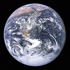
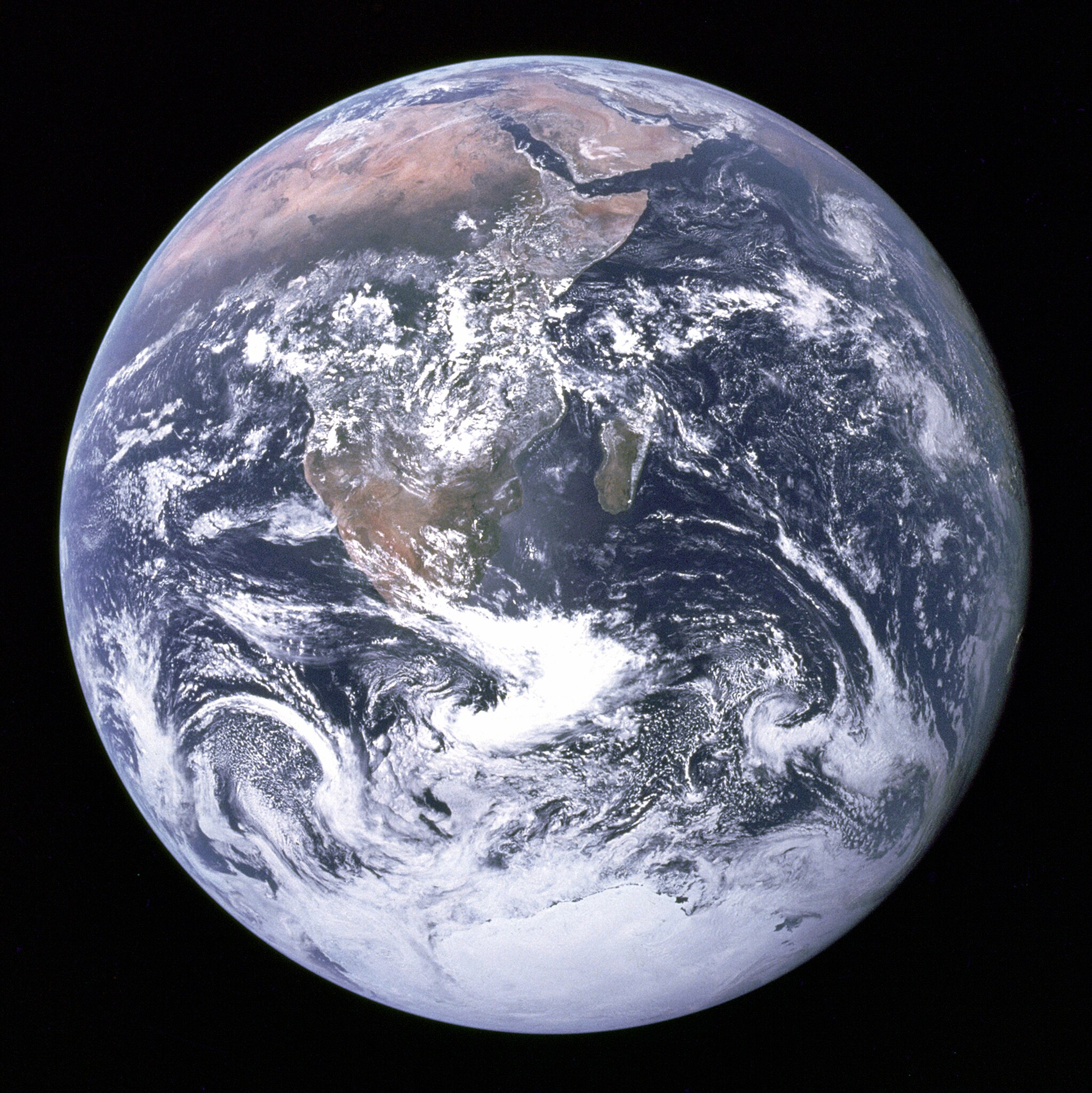
English: "The Blue Marble" is a famous photograph of the Earth taken on December 7, 1972, by the crew of the Apollo 17 spacecraft en route to the Moon at a distance of about 29,400 kilometres (18,300 mi). It shows Africa, Antarctica, and the Arabian Peninsula.
فارسی: «تیلهٔ آبی» تصویر معروفی از زمین که در ۷ دسامبر ۱۹۷۲ توسط خدمهٔ فضاپیمای آپولو ۱۷ در مسیر ماه در حدود ۲٬۹۰۰ کیلومتری زمین گرفته شده است و قسمتهایی از آفریقا، جنوبگان و شبه جزیرهٔ عرب را نشان میدهد.
Suomi: Sininen marmorikuula.
Français : «La bille bleue» : Photo de l'Afrique, de l'Antarctique et de la péninsule Arabique prise en route pour la lune par Harrison Schmitt ou Ron Evans lors de la mission Apollo 17 le 7 décembre 1972. Ce vol a été le dernier à quitter l'orbite terrestre, et le seul au cours duquel un géologue, Harrison Schmitt, s'est rendu sur la lune.
हिन्दी: "द ब्लू मार्बल" लगभग 29,400 kilometres (18,300 mi) की ऊँचाई पर चन्द्रमा की यात्रा पर गये अंतरिक्षयान अपोलो १७ के सदस्यों द्वारा दिसम्बर २००७ को लिया गया प्रसिद्ध चित्र है। इसमें अफ़्रीका, अंटार्कटिका और अरबी प्रायद्वीप दिखाई दे रहे हैं।
Italiano: Famosa fotografia della Terra ripresa il 7 dicembre 1972 dall'equipaggio della missione Apollo 17 diretta verso la Luna, da una distanza di circa 29.400 km.
Magyar: A „Kék üveggolyó”, egy híres fénykép a Földről, amelyet a Hold felé tartó Apollo–17 űrhajó legénysége készített 1972. december 7-én, mintegy 29 ezer kilométer távolságból. Jól látható rajta egész Afrika, az Arab-félsziget és az Antarktisz.
Македонски: „Сината џамлија“ е позната фотографија на Земјата направена на 7 декември 1972 од екипажот на вселенското летало Аполо 17 патувајќи кон Месечината. Сликана е на растојание од 29.400 километри, а на неа се гледаат Африка, Антарктикот и Арапскиот Полуостров.
Português: A Bolinha Azul é uma fotografia famosa da Terra tirada a 7 de dezembro de 1972 durante a missão Apollo 17, quando se encontrava a caminho da Lua e a 29,400 quilómetros da Terra.
Українська: Блакитна іграшкова куля — відома фотографія Землі, зроблена 7 грудня 1972 року командою космічного апарату «Аполлон-17».
中文:蓝色弹珠 是一张在1972年12月7日由阿波罗17号太空船船员所拍摄的著名地球照片。当时太空船正运行至距离地球29,400公里(18,300英里)之处。
日本語: ザ・ブルー・マーブルは、月へ向かうアポロ17号のクルーが1972年12月7日に撮影した有名な地球の写真。29,400km離れた距離から撮影された。アフリカ、アラビア半島、南極大陸、インド洋などを捉えている。
Čeština: Modrá skleněnka je fotografie planety Země, kterou 7. prosince 1972 pořídila posádka Apolla 17 ze vzdálenosti zhruba 29 400 kilometrů. |
|
| 日期 | 1972年十二月7日 | |
| 來源 | https://web.archive.org/web/20160112123725/http://grin.hq.nasa.gov/ABSTRACTS/GPN-2000-001138.html (image link); see also https://www.nasa.gov/multimedia/imagegallery/image_feature_329.html | |
| 其他版本 |
[] Other versions:
Derivative works:
|
|


.jpg)
.jpg)


.jpg)


| 目標地點 | | 位於此地的本圖片與其他圖片: OpenStreetMap |
|---|
本圖像或影音收錄於美國國家航空暨太空總署 (NASA)休士頓太空中心(Johnson Space Center),其照片編號為: AS17-148-22727 此標籤不表示文件的著作權狀態。任何文件在附有此標籤的同時還需要一個有效的著作權標籤。請參閱許可協議說明頁面以了解更多資訊。 其他語言:
|
本圖像或影音收錄於美國國家航空暨太空總署 (NASA)Great Pictures of NASA,其照片編號為: GPN-2000-001138 此標籤不表示文件的著作權狀態。任何文件在附有此標籤的同時還需要一個有效的著作權標籤。請參閱許可協議說明頁面以了解更多資訊。 其他語言:
|
評價
|


|
This is one of the images forming part of the Valued image set: Earth from space on Wikimedia Commons. The image set has been assessed under the valued image set criteria and is considered the most valued set on Commons within the scope:
You can see its nomination at Commons:Valued image candidates/Earth from space. |
This image was selected as picture of the day on Wikimedia Commons for 20 August 2006. It was captioned as follows: Other languages:
閩南語 / Bân-lâm-gú: Tiàm Apollo 17-hō thài-kong pe-chûn téng-kôan, iōng thian-bûn-kiàⁿ khòaⁿ tē-kiû ê kéng-tì. Cymraeg: Y Ddaear, delwedd oddiwrth Apollo 17. Dansk: Jorden set fra Apollo 17 Deutsch: Blick auf die Erde von der Apollo 17. Français : La Terre vue depuis Apollo 17. Galego: The Blue Marble: Fotografía da Terra tomada, o 7 de decembro de 1972, pola tripulación do Apollo 17 na súa ruta cara a Lúa. Mostra África, a Antártida e a península Arábiga. Foi tomada a unha distancia de 45.000 km aproximadamente Português: A Terra vista desde a Apollo 17. Suomi: Apollo 17:n ottama kuva maapallosta. العربية : الأرض كما شوهدت من ابولو 17. |
This image was selected as picture of the day on Vietnamese Wikipedia.
|
這張圖片被選為孟加拉語維基百科上的每日圖片。
|
授權條款
| 本作品由NASA創作,屬於公有領域。根據NASA的版權政策:“NASA的創作除非另有聲明否則不受版權保護。”(參見:Template:PD-USGov/zh,NASA版權政策或JPL圖像使用政策) | ||
 |
警告:
|
Additional information
Source: http://nssdc.gsfc.nasa.gov/imgcat/html/object_page/a17_h_148_22727.html
| “ | Earth - Apollo 17
Full Earth showing Africa and Antarctica Apollo 17 hand-held Hasselblad picture of the full Earth. This picture was taken on 7 December 1972, as the spacecraft traveled to the moon as the last of the Apollo missions. A remarkably cloud-free Africa is at upper left, stretching down to the center of the image. Saudi Arabia is visible at the top of the disk and Antarctica and the south pole are at the bottom. Asia is on the horizon is at upper right. The Earth is 12,740 km (7,920 mi) in diameter. (Apollo 17, AS17-148-22727) Location & Time Information |
” |
檔案歷史
點選日期/時間以檢視該時間的檔案版本。
| 日期/時間 | 縮圖 | 尺寸 | 用戶 | 備註 | |
|---|---|---|---|---|---|
| 目前 | 2020年9月25日 (五) 20:35 | | 3,000 × 3,002(6.21 MB) | Huntster(對話 | 貢獻) | Reverted to version as of 07:45, 18 December 2012 (UTC); please upload signficantly different versions under a new filename. |
| 2020年9月25日 (五) 18:29 |  | 2,500 × 2,500(8.56 MB) | D2Owiki(對話 | 貢獻) | Taken from the recent scans from 2015, downloadable for free on the Project Apollo Archive's flickr account. the image is approx. 2500 px. resolution | |
| 2012年12月18日 (二) 07:45 |  | 3,000 × 3,002(6.21 MB) | Huntster(對話 | 貢獻) | Reverted to version as of 02:25, 31 July 2005; please do not overwrite featured pictures with modified versions. | |
| 2012年12月17日 (一) 14:11 |  | 2,400 × 2,400(2.98 MB) | Adzo.1(對話 | 貢獻) | Image refaite directement à partir du fichier source NASA AS17-148-22727. | |
| 2010年10月17日 (日) 07:42 |  | 3,000 × 3,002(6.21 MB) | Huntster(對話 | 貢獻) | Reverted to version as of 02:25, 31 July 2005; new image is (in my opinion) technically inferior to the July 2005 image, and is not the featured picture that was voted upon. Upload new image to another filename if desired. | |
| 2010年10月17日 (日) 06:16 |  | 3,720 × 3,796(10.46 MB) | Jeff G.(對話 | 貢獻) | *Higher-quality and higher-resolution image: apollo17_earth.tiff as contained by ftp://nssdcftp.gsfc.nasa.gov/photo_gallery/hi-res/planetary/earth/apollo17_earth.tiff.gz and converted to JPEG with 100% quality using [[w:Paint.NET|Paint.NET v3.5 | |
| 2005年7月31日 (日) 02:25 |  | 3,000 × 3,002(6.21 MB) | Tom(對話 | 貢獻) | larger image | |
| 2004年12月29日 (三) 22:41 |  | 1,860 × 1,898(762 KB) | Ed g2s(對話 | 貢獻) | {{PD-USGov-NASA}} |
無法覆蓋此檔案。
檔案用途
超過 100 個頁面有用到此檔案。 下列清單只列出前 100 筆有用到此檔案的頁面。 您也可以檢視完整清單。
- 1972
- Apollo 17
- Art
- Earth
- Environmentalism
- Spherical Earth
- Valued image set: Earth from space
- User:Benny Hwang
- User:Diptanshu Das
- User:Galdrad
- User:Hein56didden
- User:I dream of horses
- User:Ineuw
- User:Jeff G.
- User:Jeff G./Userboxes
- User:JoSongoku
- User:Kstigarbha/gallery
- User:Marquinhos
- User:NormanB
- User:OekelWm
- User:Pandark
- User:StefanosKills
- User:Strakhov
- User:Sturm
- User:Thgoiter/Favourites
- User talk:Bambirucho
- User talk:Calandrella
- User talk:Fitgym
- User talk:Gasface11~commonswiki
- User talk:J73364
- User talk:Mattbuck/Archive2
- Commons:Deletion requests/File:Erde.png
- Commons:Featured picture candidates/File:The Earth seen from Apollo 17.png
- Commons:Featured picture candidates/Image:The Earth seen from Apollo 17.jpg
- Commons:Featured picture candidates/Log/November 2005
- Commons:Featured picture candidates/Log/October 2010
- Commons:Featured pictures/Astronomy
- Commons:Featured pictures/chronological/2005-B
- Commons:Gambar Pilihan/Astronomi
- Commons:Potd/2006-08 (fr)
- Commons:Potd/2006-08 (pl)
- Commons:Potd/2006-08 (pt)
- Commons:Potd/2006-08 (sv)
- Commons:Potd/2006-08 (tr)
- Commons:Userboxes/Location
- Commons:Valued image candidates/Earth from space
- Commons talk:Featured picture candidates/Archive candidate list
- File:4 Terrestrial Planets Size Comp True Color.png
- File:Apollo17WorldReversed.jpg
- File:Apollo 17 Image Of Earth From Space.jpeg
- File:C Data Users DefApps AppData INTERNETEXPLORER Temp Saved Images 187px-The Earth seen from Apollo 17.jpg (檔案重新導向)
- File:Es-Anuncio-Imagina.gif
- File:Exoplanet Comparison CoRoT-7 b.png
- File:Exoplanet Comparison GJ 1214 b.png
- File:Exoplanet Comparison Gliese 581 c.png
- File:Exoplanet Comparison Gliese 581 d.png
- File:Exoplanet Comparison Gliese 581 e.png
- File:Exoplanet Comparison Gliese 581 f.png
- File:Exoplanet Comparison Gliese 581 g.png
- File:Exoplanet Comparison Kepler-10 b.png
- File:Exoplanet Comparison Kepler-10 c.png
- File:Exoplanet Comparison Kepler-11 b.png
- File:Exoplanet Comparison Kepler-11 f.png
- File:Exoplanet Comparison Kepler-186 f.png
- File:Exoplanet Comparison Kepler-78 b.png
- File:Exoplanet Comparison PSR B1257+12 A.png
- File:Exoplanet Comparison PSR B1257+12 B.png
- File:Exoplanet Comparison PSR B1257+12 C.png
- File:Full Earth - GPN-2000-001138.jpg (檔案重新導向)
- File:Photomontage (Forggensee Panorama) -2.jpg
- File:Ptolemaic system (PSF)2.png
- File:The Earth seen from Apollo 17.tiff
- File:The Earth seen from Apollo 17 with transparent background.png
- File:The Earth seen from Apollo 17 with white background.jpg
- Template:Potd/2006-08
- Template:Potd/2006-08-20
- Template:Potd/2006-08-20 (ar)
- Template:Potd/2006-08-20 (cs)
- Template:Potd/2006-08-20 (cy)
- Template:Potd/2006-08-20 (da)
- Template:Potd/2006-08-20 (de)
- Template:Potd/2006-08-20 (en)
- Template:Potd/2006-08-20 (es)
- Template:Potd/2006-08-20 (et)
- Template:Potd/2006-08-20 (fi)
- Template:Potd/2006-08-20 (fr)
- Template:Potd/2006-08-20 (gl)
- Template:Potd/2006-08-20 (hu)
- Template:Potd/2006-08-20 (it)
- Template:Potd/2006-08-20 (ja)
- Template:Potd/2006-08-20 (km)
- Template:Potd/2006-08-20 (ko)
- Template:Potd/2006-08-20 (nan)
- Template:Potd/2006-08-20 (nb)
- Template:Potd/2006-08-20 (nl)
- Template:Potd/2006-08-20 (nn)
- Template:Potd/2006-08-20 (pl)
- Template:Potd/2006-08-20 (pt)
- Template:Potd/2006-08-20 (ru)
- Template:Potd/2006-08-20 (sv)
_-2.jpg)
2.png)
檢視連結到這個檔案的更多連結。
全域檔案使用狀況
以下其他 wiki 使用了這個檔案:
- ab.wikipedia.org 的使用狀況
- af.wikipedia.org 的使用狀況
- Aarde
- Sonnestelsel
- Water
- Melkweg
- Plaaslike Borrel
- Aardverwarming
- Gebruiker:Anrie/Spogbeelde
- Wikipedia:Voorbladartikels 2009
- Wikipedia:Voorbladbeeld week 2 2009
- Heelal
- Wikipedia:Beeld van die week/2009
- Wikipedia:Voorbladartikel week 50 2009
- Werklikheid
- Wikipedia:Voorbladartikels 2012
- Lewe
- Wikipedia:Voorbladartikel week 23 2012
- Multiversum
- Plaaslike Groep
- Virgo-superswerm
- Lys van Melkweg se satelliet-sterrestelsels
- Orion-Cygnus-arm
- Gaia-hipotese
- Seldsame Aarde-hipotese
- Sjabloon:Aarde-posisie
- Plaaslike Interstellêre Wolk
- Laniakea-superswerm
- Gould-gordel
- Ouderdom van die Aarde
- Wikipedia:Voorbladartikels 2017
- Wikipedia:Voorbladartikel week 18 2017
- Wikipedia:Voorbladartikels 2018
- Wikipedia:Voorbladartikel week 8 2018
- Ruimteverkenning
- Sigbare heelal
- Vroegste bekende lewensvorme
- Sjabloon:LeweOpAarde
- als.wikipedia.org 的使用狀況
- alt.wikipedia.org 的使用狀況
- ang.wikipedia.org 的使用狀況
- ang.wikibooks.org 的使用狀況
檢視此檔案的更多全域使用狀況。