File:The Roman fort of Gariannonum - view northwest - geograph.org.uk - 693481.jpg
Jump to navigation
Jump to search
No higher resolution available.
The_Roman_fort_of_Gariannonum_-_view_northwest_-_geograph.org.uk_-_693481.jpg (640 × 480 pixels, file size: 163 KB, MIME type: image/jpeg)
Captions
Captions
Add a one-line explanation of what this file represents
Summary
[edit]
| Description |
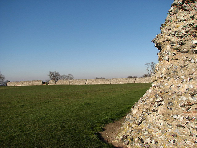
English: The Roman fort of Gariannonum - view northwest Looking NW towards north wall from east wall. Originally a Norman earthwork motte and bailey fortress that had been built within the stone walls of the Roman fort of Gariannonum, dated to the late 3rd century. The first recorded motte in England dates from 1051, built by French castle builders for the English king in Hereford; by the death of William the Conqueror in 1087 they were a common feature. At Burgh Castle, the motte with surrounding ditch was raised over the wall at the southwestern corner, and a rampart supporting a timber palisade was constructed on the western side. During the 18th century the motte was levelled and only fragments of the earthworks remain. The site, owned by English Heritage, is freely accessible; it offers magnificent views across the marshes extending westwards.
http://www.historylearningsite.co.uk/motte_and_bailey_castles.htm |
| Date | |
| Source | From geograph.org.uk |
| Author | Evelyn Simak |
| Attribution (required by the license) | Evelyn Simak / The Roman fort of Gariannonum - view northwest / |
| Camera location | | View this and other nearby images on: OpenStreetMap |
|---|
_heading:315.00&language=en)
| Object location | | View this and other nearby images on: OpenStreetMap |
|---|
_heading:315.00&language=en)
Licensing
[edit]

|
This image was taken from the Geograph project collection. See this photograph's page on the Geograph website for the photographer's contact details. The copyright on this image is owned by Evelyn Simak and is licensed for reuse under the Creative Commons Attribution-ShareAlike 2.0 license.
|
This file is licensed under the Creative Commons Attribution-Share Alike 2.0 Generic license.
Attribution: Evelyn Simak
- You are free:
- to share – to copy, distribute and transmit the work
- to remix – to adapt the work
- Under the following conditions:
- attribution – You must give appropriate credit, provide a link to the license, and indicate if changes were made. You may do so in any reasonable manner, but not in any way that suggests the licensor endorses you or your use.
- share alike – If you remix, transform, or build upon the material, you must distribute your contributions under the same or compatible license as the original.
File history
Click on a date/time to view the file as it appeared at that time.
| Date/Time | Thumbnail | Dimensions | User | Comment | |
|---|---|---|---|---|---|
| current | 06:23, 8 February 2011 | | 640 × 480 (163 KB) | GeographBot (talk | contribs) | == {{int:filedesc}} == {{Information |description={{en|1=The Roman fort of Gariannonum - view northwest Looking NW towards north wall from east wall. Originally a Norman earthwork motte and bailey fortress that had been built within the stone walls of the |
You cannot overwrite this file.
File usage on Commons
There are no pages that use this file.
File usage on other wikis
The following other wikis use this file:
- Usage on da.wikipedia.org
- Usage on en.wikipedia.org
- Usage on en.wikibooks.org
- Usage on ru.wikipedia.org