File:The SCOTS settlement in AMERICA calle'd NEW CALEDONIA - Herman Moll, 1732-1736 - BL Maps K.Top.124.24.1 (BLL01018640938).jpg

Original file (2,678 × 3,343 pixels, file size: 1.55 MB, MIME type: image/jpeg)
Captions
Captions
| Title |
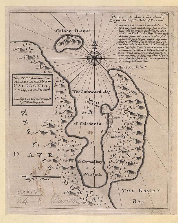
English: The SCOTS settlement in AMERICA calle'd NEW CALEDONIA. : A.D. 1699. Lat. 8-30' North. According to an Origenal Draught / By H. Moll Geographer. |
|||||||||||||||||||||||
| Description |
English: A map of the Scottish settlement in Caledonia Bay (New Caledonia with New Edinburgh and Fort of St. Andrews), in use 1698-1700. The colony was abandoned in 1700 by remaining survivors of malaria (Encyclopædia Britannica). Published in H. Moll's "Atlas minor", 1732 or 1736. |
|||||||||||||||||||||||
| Date | [1732-1736] | |||||||||||||||||||||||
| Source |
Part of King George III's Topographical Collection. Donated to the nation by George IV. Please do not overwrite this file. Any cropped or modified version should be uploaded with a new name and linked in the "
|
|||||||||||||||||||||||
| Creator |
Cartographer:
|
|||||||||||||||||||||||
| Permission (Reusing this file) |
|
|||||||||||||||||||||||
| Geotemporal data | ||||||||||||||||||||||||
| Map location |
Darien scheme |
|||||||||||||||||||||||
| Scale | 1:90,000 | |||||||||||||||||||||||
| OpenStreetMap zoom level | 13 | |||||||||||||||||||||||
| Bounding box |
|
|||||||||||||||||||||||
| Georeferencing | If inappropriate please set warp_status = skip to hide. | |||||||||||||||||||||||
| Bibliographic data | ||||||||||||||||||||||||
| Language | English | |||||||||||||||||||||||
| Place of publication | [London] : [Thomas and John Bowles] | |||||||||||||||||||||||
| Publisher |
|
|||||||||||||||||||||||
| Archival data | ||||||||||||||||||||||||
| Collection | ||||||||||||||||||||||||
| Accession number |
British Library Maps K.Top.124.24.1 |
|||||||||||||||||||||||
| Dimensions | height: 25 cm (9.8 in); width: 21 cm (8.2 in) | |||||||||||||||||||||||
| Metadata note | Initial version of this page based on information from the BL catalogue entry, updated 2017-12-08. Used with permission. Accessed 2018-09-18. | |||||||||||||||||||||||


File history
Click on a date/time to view the file as it appeared at that time.
| Date/Time | Thumbnail | Dimensions | User | Comment | |
|---|---|---|---|---|---|
| current | 11:50, 22 September 2018 | | 2,678 × 3,343 (1.55 MB) | JhealdBot (talk | contribs) | JhealdBot(6): test upload |
You cannot overwrite this file.
File usage on Commons
The following page uses this file:
.jpg)
.jpg&oldid=765396142)