File:The White Hart, Overton, Hampshire (geograph 4666776).jpg
Jump to navigation
Jump to search

Size of this preview: 800 × 486 pixels. Other resolutions: 320 × 194 pixels | 640 × 389 pixels | 1,024 × 622 pixels | 1,280 × 777 pixels | 2,560 × 1,555 pixels | 4,467 × 2,713 pixels.
Original file (4,467 × 2,713 pixels, file size: 5.01 MB, MIME type: image/jpeg)
Captions
Captions
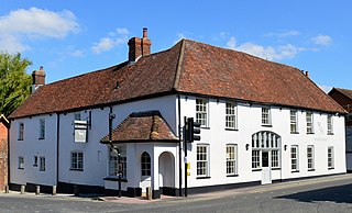
The White Hart, Overton, Hampshire. C17, C18, early C19. Building on the corner with Kingsclere Road, being an old coaching inn. Some exposed timber-framing at the rear, but the facades are mainly C18, now rendered. The south elevation is of 2 st ...
Summary
[edit].jpg&action=edit§ion=1)
| Description |
English: The White Hart, Overton, Hampshire. C17, C18, early C19. Building on the corner with Kingsclere Road, being an old coaching inn. Some exposed timber-framing at the rear, but the facades are mainly C18, now rendered. The south elevation is of 2 storeys, 6 windows; hipped tile roof, rendered walls, plinth. Sashes in exposed frames; a C20 doorway has a tall cambered head (the archway to the former coach entrance), the upper part glazed and the lower having a panelled door with windows on each side. The west elevation has an angular bay, with a later arched entrance at its south side, further north the lower walling has flint panels. The boundary wall on the east side of Kingsclere Road comprises close bands of red brickwork, alternating with flint facings, broken by brick verticals, and other verticals formed by stone squares in the flint panels. The wall ends in a lobby attached to the main buildings, with a slate roof, 2 high-level openings, and an arched doorway set in a square recess surrounded by flint panelling. To the east of the house, there is a single-storeyed block, still retaining parts of its original construction as a stable. Within, there is a Tudor fireplace in stonework, with rose design in the spandrels. |
| Date | Taken on 10 September 2015 |
| Source | From geograph.org.uk |
| Author | Oswald Bertram |
| Permission (Reusing this file) |
Creative Commons Attribution Share-alike license 2.0 |
| Attribution (required by the license) | Oswald Bertram / The White Hart, Overton, Hampshire / |
| Camera location | | View this and other nearby images on: OpenStreetMap |
|---|
.jpg¶ms=051.243797_N_-001.263304_E_globe:Earth_type:camera_source:geograph-osgb36(SU51524966)_heading:45.00&language=en)
| Object location | | View this and other nearby images on: OpenStreetMap |
|---|
.jpg¶ms=051.244060_N_-001.262870_E_globe:Earth_class:object_type:object_source:geograph-osgb36(SU51554969)_heading:45.00&language=en)
Licensing
[edit].jpg&action=edit§ion=2)

|
This image was taken from the Geograph project collection. See this photograph's page on the Geograph website for the photographer's contact details. The copyright on this image is owned by Oswald Bertram and is licensed for reuse under the Creative Commons Attribution-ShareAlike 2.0 license.
|
This file is licensed under the Creative Commons Attribution-Share Alike 2.0 Generic license.
Attribution: Oswald Bertram
- You are free:
- to share – to copy, distribute and transmit the work
- to remix – to adapt the work
- Under the following conditions:
- attribution – You must give appropriate credit, provide a link to the license, and indicate if changes were made. You may do so in any reasonable manner, but not in any way that suggests the licensor endorses you or your use.
- share alike – If you remix, transform, or build upon the material, you must distribute your contributions under the same or compatible license as the original.
File history
Click on a date/time to view the file as it appeared at that time.
| Date/Time | Thumbnail | Dimensions | User | Comment | |
|---|---|---|---|---|---|
| current | 11:19, 6 October 2022 | | 4,467 × 2,713 (5.01 MB) | Chris j wood (talk | contribs) | == {{int:filedesc}} == {{Information |Description={{en|1=The White Hart, Overton, Hampshire}} |Source=From [https://www.geograph.org.uk/photo/4666776 geograph.org.uk] |Date={{Taken on|2015-09-10|location=United Kingdom}} |Author=[https://www.geograph.org.uk/profile/117986 Oswald Bertram] |Permission=Creative Commons Attribution Share-alike license 2.0 |Other fields={{Credit line |Author=Oswald Bertram |License=[https://creativecommons.org/licenses/by-sa/2.0/ CC BY-SA 2.0] |Other=''The Whit... |
You cannot overwrite this file.
File usage on Commons
The following page uses this file:
File usage on other wikis
The following other wikis use this file:
- Usage on www.wikidata.org
.jpg&oldid=694625058)