File:The adobe home of William Ide at the William B. Ide Adobe State Historic Park in Red Bluff, California LCCN2013631148.tif
Jump to navigation
Jump to search

Size of this JPG preview of this TIF file: 800 × 534 pixels. Other resolutions: 320 × 214 pixels | 640 × 427 pixels | 1,024 × 683 pixels | 1,280 × 854 pixels | 2,560 × 1,709 pixels | 7,360 × 4,912 pixels.
Original file (7,360 × 4,912 pixels, file size: 206.91 MB, MIME type: image/tiff)
Captions
Captions
Add a one-line explanation of what this file represents
Summary
[edit]| Description |
English: Title: The adobe home of William Ide at the William B. Ide Adobe State Historic Park in Red Bluff, California
Physical description: 1 photograph : digital, tiff file, color. Notes: Title, date, and keywords provided by the photographer.; Credit line: The Jon B. Lovelace Collection of California Photographs in Carol M. Highsmith's America Project, Library of Congress, Prints and Photographs Division.; Gift; The Capital Group Companies Charitable Foundation in memory of Jon B. Lovelace; 2012; (DLC/PP-2012:063).; Forms part of: Jon B. Lovelace Collection of California Photographs in Carol M. Highsmith's America Project in the Carol M. Highsmith Archive.; Ide, a Massachusetts native, was a local judge in this northern part of the state. He wrote the proclamation that established the short-lived California Bear Republic in 1846. He was the republic's president while it lasted -- for 22 days! Contrary to the quiet, rural impression the park leaves today, the ranch's location near the California-Oregon Road and adjacent to the Sacramento River (important communication and transportation arteries) probably kept its residents well connected. |
||||||||||||||||||||||||||
| Date | Taken on 8 December 2012, 16:18 (according to Exif data) | ||||||||||||||||||||||||||
| Source |
Library of Congress
|
||||||||||||||||||||||||||
| Author |
|
||||||||||||||||||||||||||
| Permission (Reusing this file) |
No known restrictions on publication.
|
||||||||||||||||||||||||||


| Camera location | | View this and other nearby images on: OpenStreetMap |
|---|
Licensing
[edit]| This work is from the Carol M. Highsmith Archive collection at the Library of Congress. According to the library, there are no known copyright restrictions on the use of this work. Carol M. Highsmith has stipulated that her photographs are in the public domain. Photographs of sculpture or other works of art may be restricted by the copyright of the artist; see Commons:FOP US#Artworks and sculptures for more information. |
 |
File history
Click on a date/time to view the file as it appeared at that time.
| Date/Time | Thumbnail | Dimensions | User | Comment | |
|---|---|---|---|---|---|
| current | 21:25, 23 September 2016 |  | 7,360 × 4,912 (206.91 MB) | Fæ (talk | contribs) | LOC 2013631148, Carol M. Highsmith collection. P5085.19889 TIFF (206.9mb) |
| 21:24, 23 September 2016 | 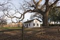 | 7,360 × 4,912 (206.91 MB) | Fæ (talk | contribs) | LOC 2013631148, Carol M. Highsmith collection. P5085.19889 TIFF (206.9mb) |
You cannot overwrite this file.
File usage on Commons
The following page uses this file: