File:The control tower at Predannack Airfield - geograph.org.uk - 2060224.jpg
Jump to navigation
Jump to search
No higher resolution available.
The_control_tower_at_Predannack_Airfield_-_geograph.org.uk_-_2060224.jpg (640 × 480 pixels, file size: 52 KB, MIME type: image/jpeg)
Captions
Captions
Add a one-line explanation of what this file represents
Summary[edit]
| Description |
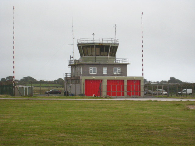
English: Predannack Airfield is a satellite of RNAS Culdrose and is used primarily as a relief landing ground for Helicopter Pilot Training. This may consist of load lifting, circuits and continuation training. The Airfield has a fully functional Control Tower, four runways and four helicopter landing spots. |
| Date | |
| Source | https://www.geograph.org.uk/photo/2060224 |
| Author | Rod Allday |
| Attribution (required by the license) | Rod Allday / The control tower at Predannack Airfield / |
| Camera location | | View this and other nearby images on: OpenStreetMap |
|---|
_heading:90.00&language=en)
| Object location | | View this and other nearby images on: OpenStreetMap |
|---|
_heading:90.00&language=en)
Licensing[edit]

|
This image was taken from the Geograph project collection. See this photograph's page on the Geograph website for the photographer's contact details. The copyright on this image is owned by Rod Allday and is licensed for reuse under the Creative Commons Attribution-ShareAlike 2.0 license.
|
This file is licensed under the Creative Commons Attribution-Share Alike 2.0 Generic license.
Attribution: Rod Allday
- You are free:
- to share – to copy, distribute and transmit the work
- to remix – to adapt the work
- Under the following conditions:
- attribution – You must give appropriate credit, provide a link to the license, and indicate if changes were made. You may do so in any reasonable manner, but not in any way that suggests the licensor endorses you or your use.
- share alike – If you remix, transform, or build upon the material, you must distribute your contributions under the same or compatible license as the original.
File history
Click on a date/time to view the file as it appeared at that time.
| Date/Time | Thumbnail | Dimensions | User | Comment | |
|---|---|---|---|---|---|
| current | 11:08, 24 February 2021 | | 640 × 480 (52 KB) | SmartyPants22 (talk | contribs) | Uploaded a work by [https://www.geograph.org.uk/profile/22976 Rod Allday] from https://www.geograph.org.uk/photo/2060224 with UploadWizard |
You cannot overwrite this file.
File usage on Commons
There are no pages that use this file.
File usage on other wikis
The following other wikis use this file:
- Usage on en.wikipedia.org
- Usage on fr.wikipedia.org