File:Three Points Lane - geograph.org.uk - 496874.jpg
Jump to navigation
Jump to search
No higher resolution available.
Three_Points_Lane_-_geograph.org.uk_-_496874.jpg (640 × 480 pixels, file size: 131 KB, MIME type: image/jpeg)
Captions
Captions
Add a one-line explanation of what this file represents
Summary
[edit]
| Description |
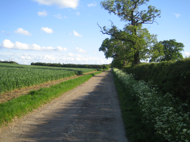
English: Three Points Lane. This view looking south is of a section of Three Points Lane between Botolph Claydon behind the camera, and Runt's Wood that is at the end of this straight stretch of lane.
Three Points Lane, which is a bridleway for most of its length, is a curiously roundabout thoroughfare changing direction several times so as to resemble the three sides of a square, hence no doubt its name. The lane is an ancient track well articulated in mid-seventeenth century maps, provided both a division between parishes, and an access route to grazing on both sides. It appears on Jefferys County Map of 1770. Starting on the C road to Claydon 400m west of Botolph Claydon, it runs south, as in this picture, to Runt's Wood, then south-west alongside the wood and across Finemere Hill, then west towards Finemerehill House. Here it crosses a north-south bridleway at its highest point, 129m, continues west still as a bridleway, and then meanders northwards alongside Sheephouse Wood to Knowlhill Farm. From the farm it is a dead-straight farm road, see 412166, running north-east back to the same C road, but now 2km west of Botolph Claydon. The total distance is 6.2km. |
| Date | |
| Source | From geograph.org.uk |
| Author | Andy Gryce |
| Attribution (required by the license) | Andy Gryce / Three Points Lane / |
| Camera location | | View this and other nearby images on: OpenStreetMap |
|---|
_heading:180.00&language=en)
| Object location | | View this and other nearby images on: OpenStreetMap |
|---|
_heading:180.00&language=en)
Licensing
[edit]

|
This image was taken from the Geograph project collection. See this photograph's page on the Geograph website for the photographer's contact details. The copyright on this image is owned by Andy Gryce and is licensed for reuse under the Creative Commons Attribution-ShareAlike 2.0 license.
|
This file is licensed under the Creative Commons Attribution-Share Alike 2.0 Generic license.
Attribution: Andy Gryce
- You are free:
- to share – to copy, distribute and transmit the work
- to remix – to adapt the work
- Under the following conditions:
- attribution – You must give appropriate credit, provide a link to the license, and indicate if changes were made. You may do so in any reasonable manner, but not in any way that suggests the licensor endorses you or your use.
- share alike – If you remix, transform, or build upon the material, you must distribute your contributions under the same or compatible license as the original.
File history
Click on a date/time to view the file as it appeared at that time.
| Date/Time | Thumbnail | Dimensions | User | Comment | |
|---|---|---|---|---|---|
| current | 06:25, 5 February 2011 | | 640 × 480 (131 KB) | GeographBot (talk | contribs) | == {{int:filedesc}} == {{Information |description={{en|1=Three Points Lane This view looking south is of a section of Three Points Lane between Botolph Claydon behind the camera, and Runt's Wood that is at the end of this straight stretch of lane. Thre |
You cannot overwrite this file.
File usage on Commons
There are no pages that use this file.