File:Three Shire Heads - geograph.org.uk - 175791.jpg
Jump to navigation
Jump to search
No higher resolution available.
Three_Shire_Heads_-_geograph.org.uk_-_175791.jpg (640 × 480 pixels, file size: 178 KB, MIME type: image/jpeg)
Captions
Captions
Add a one-line explanation of what this file represents
This is a photo of listed building number 1145883. |
Summary
[edit]
| Description |
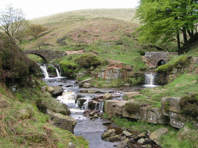
English: Three Shire Heads Bridge and waterfall, at the junction of the Cheshire, Derbyshire and Staffordshire county boundaries. Derbyshire is in the centre, beyond and between the two streams. Cheshire is to the left and Staffordshire is to the right. The left-hand stream is the River Dane; the right-hand is unnamed on the map, but is presumably Black Clough, after which a nearby farm is named. The pool is Panniers Pool, a references to the packhorses for whom the bridges were built. |
| Date | |
| Source | From geograph.org.uk |
| Author | Dave Dunford |
| Attribution (required by the license) | Dave Dunford / Three Shire Heads / |
| Object location | | View this and other nearby images on: OpenStreetMap |
|---|
_heading:22.00&language=en)
Licensing
[edit]

|
This image was taken from the Geograph project collection. See this photograph's page on the Geograph website for the photographer's contact details. The copyright on this image is owned by Dave Dunford and is licensed for reuse under the Creative Commons Attribution-ShareAlike 2.0 license.
|
This file is licensed under the Creative Commons Attribution-Share Alike 2.0 Generic license.
Attribution: Dave Dunford
- You are free:
- to share – to copy, distribute and transmit the work
- to remix – to adapt the work
- Under the following conditions:
- attribution – You must give appropriate credit, provide a link to the license, and indicate if changes were made. You may do so in any reasonable manner, but not in any way that suggests the licensor endorses you or your use.
- share alike – If you remix, transform, or build upon the material, you must distribute your contributions under the same or compatible license as the original.
File history
Click on a date/time to view the file as it appeared at that time.
| Date/Time | Thumbnail | Dimensions | User | Comment | |
|---|---|---|---|---|---|
| current | 16:10, 31 January 2010 | | 640 × 480 (178 KB) | GeographBot (talk | contribs) | == {{int:filedesc}} == {{Information |description={{en|1=Three Shire Heads. Variously known as "Three Shires Head" (probably the most popular form) and "Three Shire Heads" (the OS's preferred designation), this is a well-known beauty spot where the counti |
You cannot overwrite this file.
File usage on Commons
There are no pages that use this file.