File:Tilisunahütte Panorama.jpg
Aller à la navigation
Aller à la recherche
Taille de cet aperçu : 800 × 211 pixels. Autres résolutions : 320 × 84 pixels | 640 × 169 pixels | 1 024 × 270 pixels | 1 280 × 337 pixels | 6 711 × 1 768 pixels.
Fichier d’origine (6 711 × 1 768 pixels, taille du fichier : 8,68 Mio, type MIME : image/jpeg)
Légendes
Légendes
Ajoutez en une ligne la description de ce que représente ce fichier
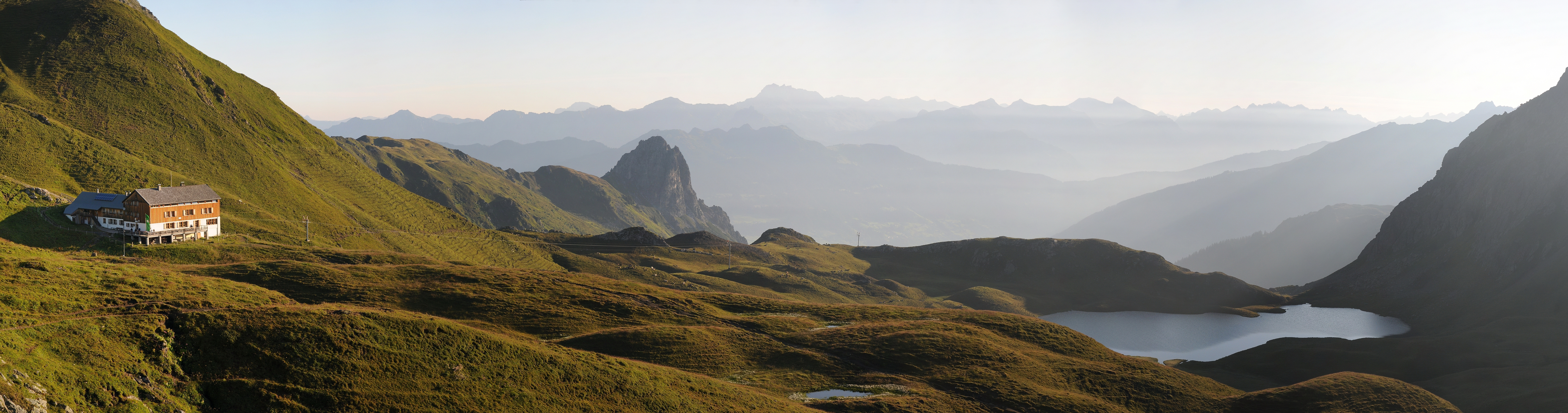
Panoramic picture of Rätikon mountain range in Austria, with Austrian Alpine Club hut Tilisunahütte on the left and Tilisunasee lake on the right.
| Description |
Čeština: Panorama z pohoří Rätikon v Rakousko, nedaleko hranic se Švýcarskem. Vlevo chata Tilisunahütte Rakouského alpského spolku ležící ve výšce 2211 m n. m.
Deutsch: Panorama um 07:10 Uhr nach dem Sonnenaufgang über dem Tilisunasee. Links die Tilisunahütte. Sie ist eine Berghütte des Österreichischen Alpenvereins (OeAV), Sektion Vorarlberg, in der Region Montafon, Bundesland Vorarlberg / Österreich. Sie liegt südlich von Tschagguns auf einer Höhe von 2'211 m ü. M. nördlich der Sulzfluh, in aussichtsreicher Lage mit Blick ins Montafon. Der Berganstieg links führt auf das Tilisuna-Schwarzhorn 2.460m und in der Bildmitte die Tschaggunser Mittagsspitze.
English: Panoramic picture of Rätikon mountain range in Austria, near the border of Switzerland, with Austrian Alpine Club hut Tilisunahütte on the left. Hut is located south of village Tschagguns in elevation of 2,211 m.
Русский: Окрестности Чаггунс, Форарльберг, Австрия.
Italiano: Foto panoramica della catena del Rätikon in Austria vicino al confine svizzero. Sulla sinistra il rifugio Tilisunahütte dell'Österreichischer Alpenverein.
|
||
| Date | |||
| Source | Travail personnel | ||
| Auteur | böhringer friedrich | ||
| Autorisation (Réutilisation de ce fichier) |
Moi, en tant que détenteur des droits d’auteur sur cette œuvre, je la publie sous la licence suivante : Ce fichier est disponible selon les termes de la licence Creative Commons Attribution – Partage dans les Mêmes Conditions 2.5 Générique
|

| Lieu de la prise de vue | | Voir cet endroit et d’autres images sur : OpenStreetMap |
|---|
Cette photo a été prise par Böhringer Friedrich.
|
N’hésitez pas à utiliser mes photographies, mais veuillez me mentionner comme auteur, et si vous le souhaitez vous pouvez me laisser un message. or (rufre@lenz-nenning.at) |
| Annotations | Cette image est annotée : Voir les annotations sur Wikimedia Commons |
Distinctions
[modifier]
|

Cette image a été choisie comme image du jour pour le 1er août 2012. La description associée était la suivante : English: Panoramic picture of Rätikon mountain range in Austria, near the border of Switzerland, with Austrian Alpine Club hut Tilisunahütte on the left. Autres langues :
English: Panoramic picture of Rätikon mountain range in Austria, near the border of Switzerland, with Austrian Alpine Club hut Tilisunahütte on the left. Italiano: Foto panoramica della catena del Rätikon in Austria vicino al confine svizzero. Sulla sinistra il rifugio Tilisunahütte dell'Österreichischer Alpenverein. Magyar: A Rätikon-hegység panorámaképe Ausztriában, közel a svájci határhoz. Bal oldalon a Tilisunahütte alpesi menedékház. Nederlands: Panoramische foto van het bergmassief Rätikon in Oostenrijk nabij de grens met Zwitserland met links de Tilisunahütte van de Österreichischer Alpenverein. Português: Imagem panorâmica da cordilheira Rätikon, na Áustria, próximo à fronteira com a Suíça. Русский: Панорама хребта Ретикон в Австрии. Слева горная хижина Тилисуна, принадлежащая Австрийскому Горному Клубу ქართული: რეტიკონის ქედის პანორამა ავსტრიაში, შვეიცარიის საზღვრის სიახლოვეს. მარცხნივ ავსტრიული სამთო კლუბის ქოხი. 中文: 雷蒂孔山在奥地利的全景图,靠近与瑞士的边境,左边有一座奥地利阿尔卑斯山俱乐部的小屋。 |
Cette image a été promue au rang d'image de qualité d'après les critères du Guide des images.
|
Historique du fichier
Cliquer sur une date et heure pour voir le fichier tel qu'il était à ce moment-là.
| Date et heure | Vignette | Dimensions | Utilisateur | Commentaire | |
|---|---|---|---|---|---|
| actuel | 2 août 2011 à 21:11 | 6 711 × 1 768 (8,68 Mio) | Böhringer (d | contributions) | {{Information |Description= {{de|Panorama um 07:10 Uhr nach dem Sonnenaufgang über dem Tilisunasee. Links die Tilisunahütte. Sie ist eine Berghütte des Österreichischen Alpenvereins (OeAV), Sektion Vorarlberg, in der Region [[:d |
Vous ne pouvez pas remplacer ce fichier.
Utilisations locales du fichier
Les 61 pages suivantes utilisent ce fichier :
- Exzellente Bilder aus Vorarlberg
- User:Böhringer
- User:Böhringer/Archive 4
- User:Chriswaterguy/Picture of the Year/2011 - larger
- User:Julian Herzog/Favorites
- User:Sadko
- User:Sadko/Template:UP
- User:Samsara/POTY 2011 overview
- User:Stefahn
- User:Ö/Best/2011
- Commons:Featured picture candidates/File:Tilisunahütte Panorama.jpg
- Commons:Featured picture candidates/Log/August 2011
- Commons:Featured pictures/Places/Natural/Austria
- Commons:Featured pictures/Places/Panoramas
- Commons:Featured pictures/chronological/2011-B
- Commons:Photo challenge/2015 - May - Panoramas
- Commons:Picture of the Year/2011
- Commons:Picture of the Year/2011/Finalists
- Commons:Picture of the Year/2011/Finalists/Tilisunahütte Panorama.jpg
- Commons:Picture of the Year/2011/Galleries/2011-B
- Commons:Picture of the Year/2011/Galleries/ALL
- Commons:Picture of the Year/2011/Galleries/AUG
- Commons:Picture of the Year/2011/Galleries/B
- Commons:Picture of the Year/2011/Galleries/B/table
- Commons:Picture of the Year/2011/Galleries/Index/11
- Commons:Picture of the Year/2011/Galleries/Index/8
- Commons:Picture of the Year/2011/Galleries/Index/ALL
- Commons:Picture of the Year/2011/Galleries/Index/Panoramic nature views
- Commons:Picture of the Year/2011/Galleries/Panoramic nature views
- Commons:Picture of the Year/2011/Galleries/Panoramic nature views/Large
- Commons:Picture of the Year/2011/Galleries/Panoramic nature views/Small
- Commons:Picture of the Year/2011/Galleries/table
- Commons:Picture of the Year/2011/R1/Tilisunahütte Panorama.jpg
- Commons:Picture of the Year/2011/Results
- Commons:Picture of the Year/2011/Results/R1/ALL/table
- Commons:Picture of the Year/2011/Results/R1/Category
- Commons:Picture of the Year/2011/Results/R1/Checking
- Commons:Picture of the Year/2011/Results/R1/Finalists
- Commons:Picture of the Year/2011/Results/R1/Finalists/table
- Commons:Picture of the Year/2011/Results/R1/Panoramic nature views
- Commons:Picture of the Year/2011/Results/R1/Panoramic nature views/table
- Commons:Picture of the Year/2011/Results/R2
- Commons:Picture of the Year/2011/Results/R2/table
- Commons:Picture of the Year/2011/Translations
- Commons:Quality images/Subject/Places/Mixed/Panorama/Archive 2008 to 2015
- Commons:Quality images candidates/Archives August 2011
- Commons:Vuoden kuva/2011/Tulokset
- Commons:ภาพแห่งปี/2011
- Commons talk:Photo challenge/themes/Archive
- Commons talk:Picture of the Year/2011/Results/R1
- Commons talk:Picture of the Year/2011/Results/R1/ALL/table
- Template:Potd/2012-08
- Template:Potd/2012-08-01
- Template:Potd/2012-08-01 (en)
- Template:Potd/2012-08-01 (hu)
- Template:Potd/2012-08-01 (it)
- Template:Potd/2012-08-01 (ka)
- Template:Potd/2012-08-01 (nl)
- Template:Potd/2012-08-01 (pt)
- Template:Potd/2012-08-01 (zh-hans)
- Template:Potd/2012-08 (zh-hans)
Utilisations du fichier sur d’autres wikis
Les autres wikis suivants utilisent ce fichier :
- Utilisation sur be-tarask.wikipedia.org
- Utilisation sur bn.wikipedia.org
- Utilisation sur crh.wikipedia.org
- Utilisation sur cv.wikipedia.org
- Utilisation sur de.wikipedia.org
- Utilisation sur en.wikipedia.org
- Utilisation sur et.wikipedia.org
- Utilisation sur hu.wikipedia.org
- Utilisation sur it.wikipedia.org
- Utilisation sur ka.wikipedia.org
- Utilisation sur ko.wikipedia.org
- Utilisation sur krc.wikipedia.org
- Utilisation sur lbe.wikipedia.org
- Utilisation sur os.wikipedia.org
- Utilisation sur ru.wikipedia.org
- Utilisation sur ru.wikinews.org
- Utilisation sur sah.wikipedia.org
- Utilisation sur sr.wikipedia.org
- Utilisation sur uk.wikipedia.org
- Utilisation sur vi.wikipedia.org
- Utilisation sur xal.wikipedia.org
- Utilisation sur zh.wikipedia.org