File:Topo 25 sheets orig.jpg

Original file (1,600 × 1,034 pixels, file size: 577 KB, MIME type: image/jpeg)
Captions
Captions
Summary[edit]
| Title |
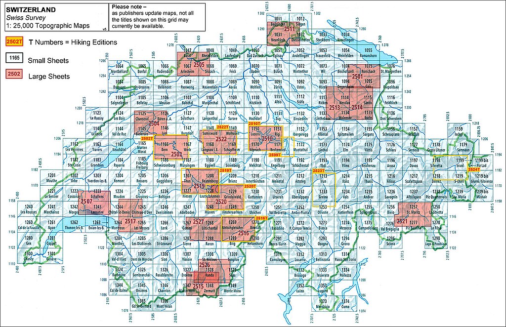
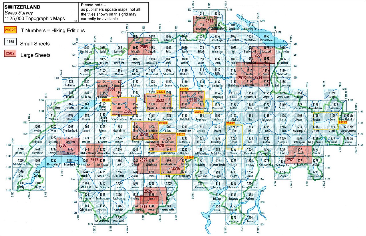
English: Sheet index for Swisstopo 1:25,000 map. |
|||||||||||||||||||||||
| Description |
English: Sheet index for National Maps of Switzerland 1:25,000 of Swiss Federal Office of Topography (Swisstopo). 19x21 grid. Standard sheets cover an area of 17.5 km x 12 km. The sheets shown are these of the print edition. Not recently printed were (not shown): 1035 Friedrichshafen, 1056 Lindau.
Français : Carte pour les feuilles Carte nationale de la Suisse 1:25 000 de l'Office fédéral de topographie (Swisstopo).
Deutsch: Blattübersicht Landeskarten der Schweiz 1:25'000 des Bundesamtes für Landestopografie (Swisstopo). Blattschnitt im Raster 19x21. Jede Standard-Karte zeigt eine Fläche von 17.5 km x 12 km. Angegeben sind die Karten der gedruckten Ausgabe. Noch nicht gedruckt (nicht angezeigt) sind: 1035 Friedrichshafen, 1056 Lindau. |
|||||||||||||||||||||||
| Date | ||||||||||||||||||||||||
| Source |
http://www.craenen.com/index.php?pid=139 https://www.stanfords.co.uk/Content/Images/uploaded/Live_Grid_Images/SI00000370_general_grid.jpg |
|||||||||||||||||||||||
| Creator |
|
|||||||||||||||||||||||
| Geotemporal data | ||||||||||||||||||||||||
| Date depicted | before 2017 (sheets 1165 and 1185 renamed) | |||||||||||||||||||||||
| Map location | Switzerland | |||||||||||||||||||||||
| Map type | index map | |||||||||||||||||||||||
| Spatial reference system | Swiss coordinate system | |||||||||||||||||||||||
| Heading |
 |
|||||||||||||||||||||||
| Bounding box |
|
|||||||||||||||||||||||
| Georeferencing | ||||||||||||||||||||||||
| Swiss grid |
|
|||||||||||||||||||||||
| Other versions |
|
|||||||||||||||||||||||


Licensing[edit]
The data made publicly available by swisstopo may be used, distributed and made accessible. Furthermore, they may be enriched and processed and also used commercially. A reference to the source is mandatory. In the case of digital or analogue representations and publications, as well as in the case of dissemination, one of the following source references must be attached in any case:
Terms of use for free geodata and geoservices (OGD) from swisstopo
|
.svg) |
File history
Click on a date/time to view the file as it appeared at that time.
| Date/Time | Thumbnail | Dimensions | User | Comment | |
|---|---|---|---|---|---|
| current | 21:05, 31 August 2023 | | 1,600 × 1,034 (577 KB) | Yann (talk | contribs) | https://www.stanfords.co.uk/content/images/thumbs/015/0156301_Live_Grid_Images_SI00000370_general_grid.jpeg |
| 20:56, 31 August 2023 |  | 1,297 × 846 (500 KB) | Yann (talk | contribs) | {{Information |Description={{en|Sheet map for Swisstop 1:25,000.}} {{fr|Carte pour les feuilles 1/25 000 de Swisstopo.}} |Source=http://www.craenen.com/index.php?pid=139 |Date=2023 |Author=Swisstop / Federal Office of Topography |Permission= |other_versions= }} =={{int:license-header}}== {{Attribution-Switzerland-mapdata}} Category:Files uploaded by Yann Forget |
You cannot overwrite this file.
File usage on Commons
The following 6 pages use this file:
- Commons:Graphic Lab/Illustration workshop/Archive/2023
- Commons:Graphic Lab/Map workshop
- File:General Map of Switzerland.jpg
- File:Landeskarte der Schweiz 1-25'000 Blattübersicht - Swisstopo Swiss Map Raster 25 index.svg
- File:National Map of Switzerland.jpg
- File:Tableau des feuilles de la Carte nationale de la Suisse 1-25 000 et Swiss Map Raster 25.svg