File:Topography of Greeley Crater ESA402027.tiff

Original file (5,572 × 7,229 pixels, file size: 92.65 MB, MIME type: image/tiff)
Captions
Captions
Summary
[edit]| Description |
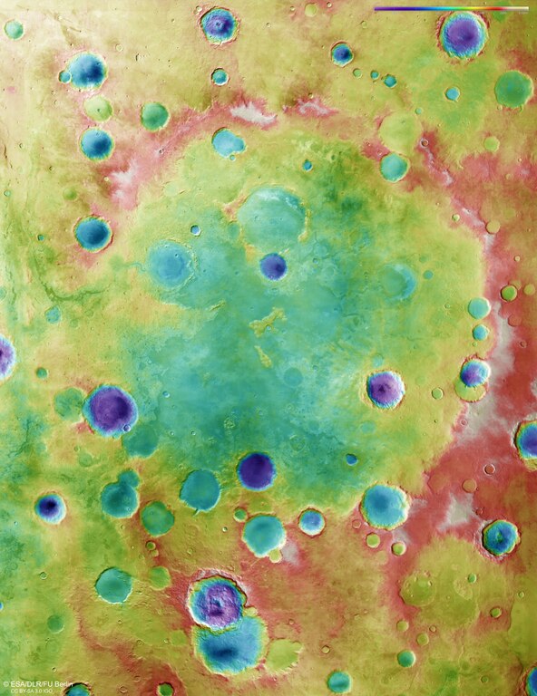
English: This image shows the relative heights of the landscape in and around Greeley crater, a degraded impact crater in the Southern Highlands of Mars.
Lower parts of the surface are shown in blues and purples, while higher-altitude regions show up in whites, browns, and reds, as indicated on the scale to the top right. The colour-coded topographic view is based on a digital terrain model of the region, from which the topography of the landscape can be derived. This coloured topographic view comprises data obtained by the High Resolution Stereo Camera on Mars Express over 16 of the spacecraft’s orbits (0430, 1910, 1932, 2412, 2467, 2478, 4306, 4317, 4328, 6556, 8613, 8620, 8708, 12835, 14719, 16778). The ground resolution is about 100 m/pixel and the images cover a part of the martian surface ranging from 2°W to 9°E / 31.5° to 43.5°S. North is up. More information |
| Date | |
| Source | http://www.esa.int/spaceinimages/Images/2018/10/Topography_of_Greeley_Crater |
| Author | European Space Agency |
| Permission (Reusing this file) |
ESA/DLR/FU Berlin,CC BY-SA 3.0 IGO |
| Title | Topography of Greeley Crater |
| Mission | Mars Express |
| Activity | Space Science |
Licensing
[edit]- You are free:
- to share – to copy, distribute and transmit the work
- to remix – to adapt the work
- Under the following conditions:
- attribution – You must give appropriate credit, provide a link to the license, and indicate if changes were made. You may do so in any reasonable manner, but not in any way that suggests the licensor endorses you or your use.
- share alike – If you remix, transform, or build upon the material, you must distribute your contributions under the same or compatible license as the original.
File history
Click on a date/time to view the file as it appeared at that time.
| Date/Time | Thumbnail | Dimensions | User | Comment | |
|---|---|---|---|---|---|
| current | 13:34, 3 April 2019 |  | 5,572 × 7,229 (92.65 MB) | Fæ (talk | contribs) | European Space Agency, Id 402027, http://www.esa.int/spaceinimages/Images/2018/10/Topography_of_Greeley_Crater, User:Fæ/Project_list/ESA |
You cannot overwrite this file.
File usage on Commons
There are no pages that use this file.