File:Trails of Tears en.png
پرش به ناوبری
پرش به جستجو

اندازهٔ این پیشنمایش: ۷۸۵ × ۶۰۰ پیکسل. کیفیتهای دیگر: ۳۱۴ × ۲۴۰ پیکسل | ۶۲۸ × ۴۸۰ پیکسل | ۱٬۰۰۵ × ۷۶۸ پیکسل | ۱٬۲۸۰ × ۹۷۸ پیکسل | ۲٬۰۲۵ × ۱٬۵۴۷ پیکسل.
پروندهٔ اصلی (۲٬۰۲۵ × ۱٬۵۴۷ پیکسل، اندازهٔ پرونده: ۳٫۰۴ مگابایت، نوع MIME پرونده: image/png)
گزینهها
عنوان
شرحی یکخطی از محتوای این فایل اضافه کنید
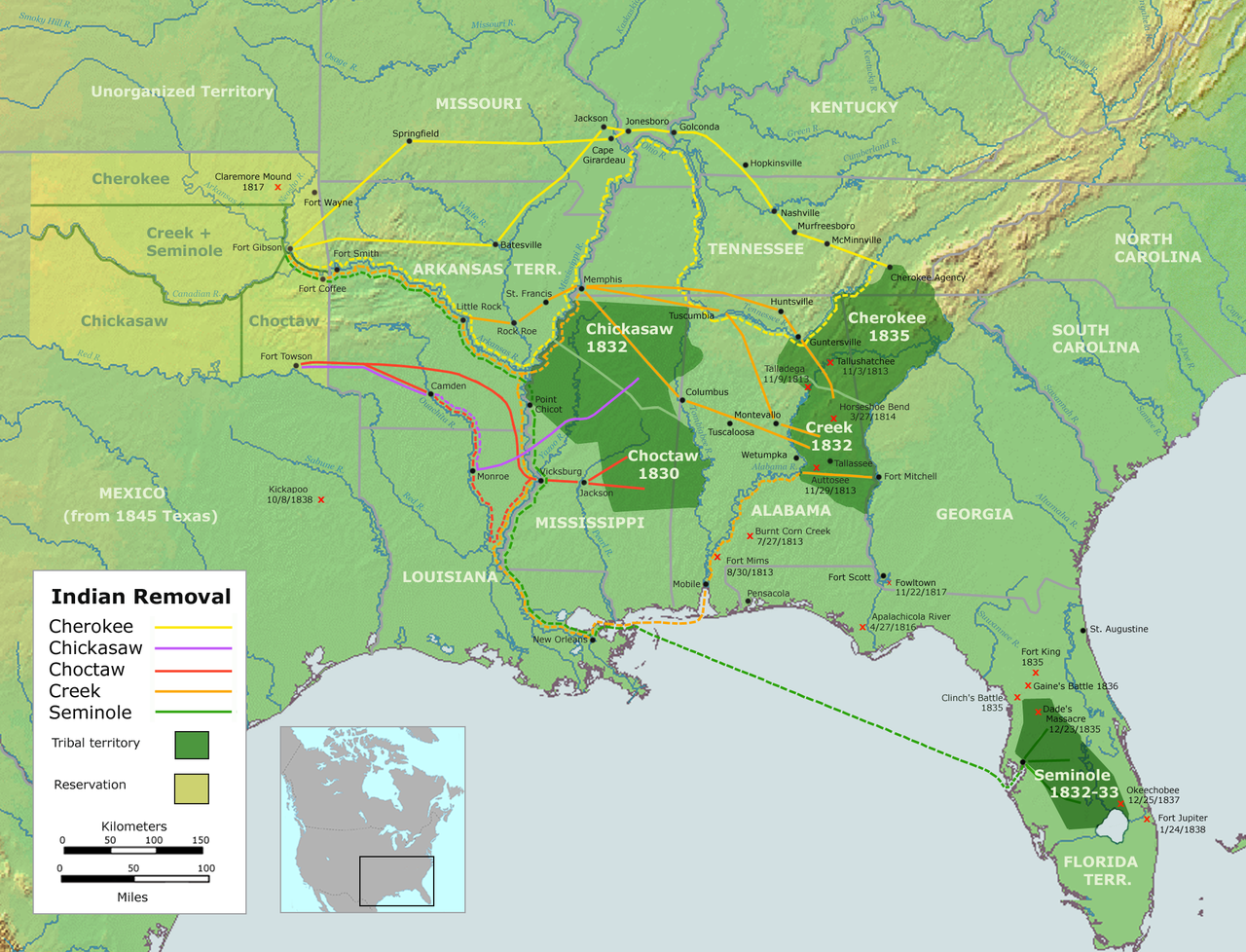
Trails of Tears — depicting the route taken to relocate Native Americans from the Southeastern United States between 1836 and 1839
خلاصه
[ویرایش]| توضیح |
English: Map of the route of the Trails of Tears — depicting the route taken to relocate Native Americans from the Southeastern United States between 1836 and 1839.
|
||||
| تاریخ | |||||
| منبع |
Own work using::
|
||||
| پدیدآور | User:Nikater | ||||
| اجازهنامه (استفادهٔ مجدد از این پرونده) |
|
||||
| دیگر نسخهها |
|

تاریخچهٔ پرونده
روی تاریخ/زمانها کلیک کنید تا نسخهٔ مربوط به آن هنگام را ببینید.
| تاریخ/زمان | بندانگشتی | ابعاد | کاربر | توضیح | |
|---|---|---|---|---|---|
| کنونی | ۴ سپتامبر ۲۰۰۷، ساعت ۱۸:۳۷ | | ۲٬۰۲۵ در ۱٬۵۴۷ (۳٫۰۴ مگابایت) | Nikater (بحث | مشارکتها) | {{Information |Description=Trails of Tears (English version) |Source=Own work by Nikater, submitted to the public domain. Background map courtesy of Demis, www.demis.nl and Wilcomb E. Washburn (Hrsg.) ''Handbook of North American Indians.'' Vol. 4: Histor |
| ۴ سپتامبر ۲۰۰۷، ساعت ۰۷:۵۵ |  | ۲٬۰۲۵ در ۱٬۵۴۷ (۳٫۰۴ مگابایت) | Nikater (بحث | مشارکتها) | {{Information |Description=Trails of Tears (English version) |Source=Own work by Nikater, submitted to the public domain. Background map courtesy of Demis, www.demis.nl and Wilcomb E. Washburn (Hrsg.) ''Handbook of North American Indians.'' Vol. 4: Histor |
نمیتوانید این پرونده را رونویسی کنید.
کاربرد پرونده
صفحهٔ زیر از این تصویر استفاده میکند:
کاربرد سراسری پرونده
ویکیهای دیگر زیر از این پرونده استفاده میکنند:
- کاربرد در af.wikipedia.org
- کاربرد در am.wikipedia.org
- کاربرد در ar.wikipedia.org
- کاربرد در az.wikipedia.org
- کاربرد در bcl.wikiquote.org
- کاربرد در be.wikipedia.org
- کاربرد در bg.wikipedia.org
- کاربرد در bn.wikipedia.org
- کاربرد در ca.wikipedia.org
- Destí Manifest
- Neteja ètnica
- Andrew Jackson
- James Monroe
- Guerres índies
- Deportació dels indis dels Estats Units
- Camí de les Llàgrimes
- Territori Indi
- Tractat de Dancing Rabbit Creek
- Camí de les Llàgrimes choctaw
- Plantilla:Deportació ameríndia
- Tractat de Payne's Landing
- Indian Removal Act
- Tractat de Doak's Stand
- Tractat de Hopewell
- Tractat de Prairie du Chien
- Usuari:Carmallola/Neteja ètnica
- کاربرد در cs.wikipedia.org
- کاربرد در de.wikipedia.org
- کاربرد در en.wikipedia.org
- Indian removal
- Winfield Scott
- History of the United States
- Trail of Tears
- Five Civilized Tribes
- History of the Southern United States
- Portal:Oklahoma
- History of Oklahoma
- History of Arkansas
- Presidency of Andrew Jackson
- User talk:Kevin1776/Archive 3
- Aboriginal title in the United States
- Cherokee Nation (1794–1907)
- User:Boompole/sandbox
- Oklahoma Organic Act
- User:Joelton Ivson/Gather lists/24319 – Indígenas América do Norte
نمایش استفادههای سراسری از این پرونده.
ردهها:
- Trail of Tears maps
- Maps of Native American tribal territories
- Maps of the history of the United States
- Maps of the Indian Territory
- Alabama in the 1830s
- Florida in the 1830s
- Georgia (U.S. state) in the 1830s
- North Carolina in the 1830s
- Oklahoma in the 1830s
- South Carolina in the 1830s
- Tennessee in the 1830s
- Texas in the 1830s
- 1836 in the United States
- 1837 in the United States
- 1838 in the United States
- 1839 in the United States
- Maps of the Southeastern United States
- Handbook of North American Indians
- Cherokee maps
- Seminole maps
- Maps showing the 1830s
- Muscogee maps
- Choctaw maps
- Chickasaw maps
- Seminole Wars
- Battles in the United States
- Battles involving Native Americans in the 1830s
- Maps of the history of Oklahoma
- Maps of the history of Florida
- Maps of the history of Georgia (U.S. state)
- Maps of the history of Alabama
- Maps of the history of Mississippi
- Maps of the history of Tennessee
- Maps of the history of Arkansas
- 1830s maps of the United States