File:Trails of Tears en.png
Ir a la navegación
Ir a la búsqueda

Kay ñawpaq qhawariypa chhikan kaynin: 785 × 600 iñu. Huk huyakukuna: 314 × 240 iñu | 628 × 480 iñu | 1005 × 768 iñu | 1280 × 978 iñu | 2025 × 1547 iñu.
Qallariy willañiqi (2025 × 1547 iñu; willañiqip chhikan kaynin: 3,04 MB; MIME laya: image/png)
Leyendas
Leyendas
Añade una explicación corta acerca de lo que representa este archivo
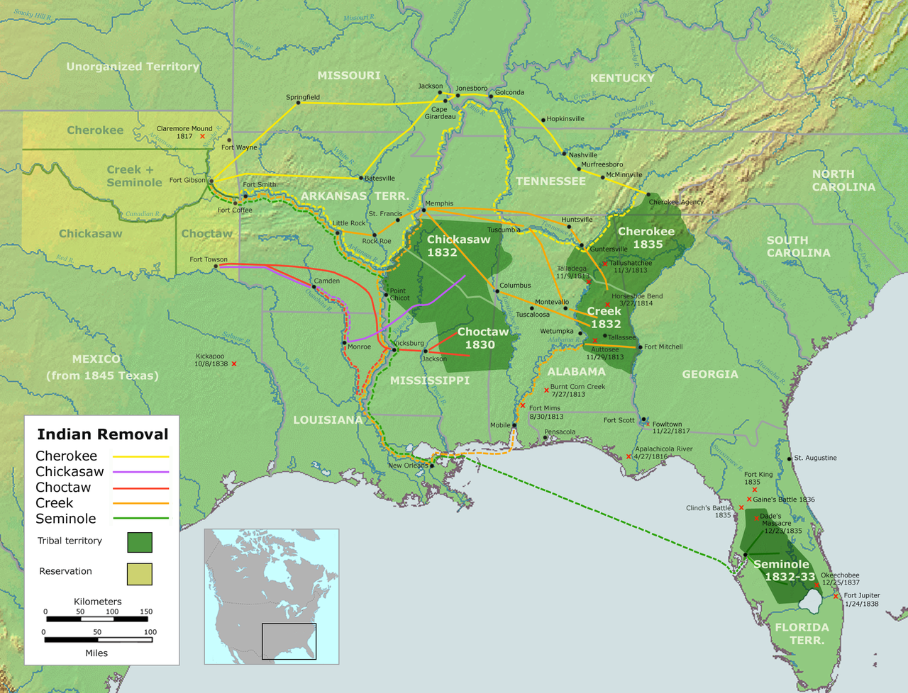
Trails of Tears — depicting the route taken to relocate Native Americans from the Southeastern United States between 1836 and 1839
Pisichay[llamk'apuy]
| T'iktuna |
English: Map of the route of the Trails of Tears — depicting the route taken to relocate Native Americans from the Southeastern United States between 1836 and 1839.
|
||||
| P'unchaw | |||||
| Pukyu |
Trabajo propio utilizando::
|
||||
| Ruraq | User:Nikater | ||||
| Saqillay (Kay willañiqita musuqmanta llamk'achiy) |
|
||||
| Huk musuqchasqakuna |
|

Willañiqip wiñay kawsaynin
P'unchaw/pacha nisqapi ñit'iy chaypacha willañiqi kachkasqata qhawanaykipaq.
| P'unchaw/Pacha | Uchuylla rikchacha | Chhikanyachikuqkuna | Ruraq | Willapuy | |
|---|---|---|---|---|---|
| kunan | 18:37 4 sit 2007 | | 2025 × 1547 (3,04 MB) | Nikater (rimanakuy | llamk'apusqakuna) | {{Information |Description=Trails of Tears (English version) |Source=Own work by Nikater, submitted to the public domain. Background map courtesy of Demis, www.demis.nl and Wilcomb E. Washburn (Hrsg.) ''Handbook of North American Indians.'' Vol. 4: Histor |
| 07:55 4 sit 2007 |  | 2025 × 1547 (3,04 MB) | Nikater (rimanakuy | llamk'apusqakuna) | {{Information |Description=Trails of Tears (English version) |Source=Own work by Nikater, submitted to the public domain. Background map courtesy of Demis, www.demis.nl and Wilcomb E. Washburn (Hrsg.) ''Handbook of North American Indians.'' Vol. 4: Histor |
Manam atinkichu kay willañiqita huknachayta.
Maypim willañiqita llamk'achinku
Kay rikchamanqa kay qatiq p'anqam t'inkimun:
Mayqin wikikunapi willañiqita llamk'achinku
Kay wakin wikikunam willañiqitaqa llamk'achinku:
- af.wikipedia.org-pi kaykunapi llamk'achinku
- am.wikipedia.org-pi kaykunapi llamk'achinku
- ar.wikipedia.org-pi kaykunapi llamk'achinku
- bcl.wikiquote.org-pi kaykunapi llamk'achinku
- be.wikipedia.org-pi kaykunapi llamk'achinku
- bg.wikipedia.org-pi kaykunapi llamk'achinku
- bn.wikipedia.org-pi kaykunapi llamk'achinku
- ca.wikipedia.org-pi kaykunapi llamk'achinku
- Destí Manifest
- Neteja ètnica
- Andrew Jackson
- James Monroe
- Guerres índies
- Deportació dels indis dels Estats Units
- Camí de les Llàgrimes
- Territori Indi
- Tractat de Dancing Rabbit Creek
- Camí de les Llàgrimes choctaw
- Plantilla:Deportació ameríndia
- Tractat de Payne's Landing
- Indian Removal Act
- Tractat de Doak's Stand
- Tractat de Hopewell
- Tractat de Prairie du Chien
- Usuari:Carmallola/Neteja ètnica
- cs.wikipedia.org-pi kaykunapi llamk'achinku
- de.wikipedia.org-pi kaykunapi llamk'achinku
- en.wikipedia.org-pi kaykunapi llamk'achinku
- Indian removal
- Winfield Scott
- History of the United States
- Trail of Tears
- Five Civilized Tribes
- History of the Southern United States
- History of Oklahoma
- History of Arkansas
- Presidency of Andrew Jackson
- User talk:Kevin1776/Archive 3
- Aboriginal title in the United States
- Cherokee Nation (1794–1907)
- User:Boompole/sandbox
- Oklahoma Organic Act
- User:Joelton Ivson/Gather lists/24319 – Indígenas América do Norte
- User:Squeakinglemur/sandbox
- Indian commerce with early English colonists and the early United States
Qhaway mayqin wikikunapim willañiqita llamk'achinku.
Katiguriyakuna:
- Trail of Tears maps
- Maps of Native American tribal territories
- Maps of the history of the United States
- Maps of the Indian Territory
- Alabama in the 1830s
- Florida in the 1830s
- Georgia (U.S. state) in the 1830s
- North Carolina in the 1830s
- Oklahoma in the 1830s
- South Carolina in the 1830s
- Tennessee in the 1830s
- Texas in the 1830s
- 1836 in the United States
- 1837 in the United States
- 1838 in the United States
- 1839 in the United States
- Maps of the Southeastern United States
- Handbook of North American Indians
- Cherokee maps
- Seminole maps
- Maps showing the 1830s
- Muscogee maps
- Choctaw maps
- Chickasaw maps
- Seminole Wars
- Battles in the United States
- Battles involving Native Americans in the 1830s
- Maps of the history of Oklahoma
- Maps of the history of Florida
- Maps of the history of Georgia (U.S. state)
- Maps of the history of Alabama
- Maps of the history of Mississippi
- Maps of the history of Tennessee
- Maps of the history of Arkansas
- 1830s maps of the United States