File:Trengslet (21619369580).jpg
Jump to navigation
Jump to search

Size of this preview: 800 × 480 pixels. Other resolutions: 320 × 192 pixels | 1,024 × 614 pixels | 1,280 × 768 pixels | 2,560 × 1,535 pixels | 3,543 × 2,125 pixels.
Original file (3,543 × 2,125 pixels, file size: 839 KB, MIME type: image/jpeg)
Captions
Captions
Add a one-line explanation of what this file represents
Summary
[edit].jpg&action=edit§ion=1)
| Description |
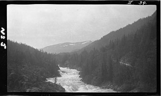
English: Elven Mår ved "Trengsle", cirka 1 km nedenfor Skårberg gård i Tinn kommune i Telemark.
English: River "Mår" near the "Trengsle" place, cirka 1 km below the Skårberg farm in Tinn commune in Telemark county, Norway |
| Date | |
| Source | Trengslet |
| Author | NVE from Norway |
| Object location | | View this and other nearby images on: OpenStreetMap |
|---|
.jpg¶ms=060.071220_N_0008.709500_E_globe:Earth_class:object_type:object__&language=en)
Licensing
[edit].jpg&action=edit§ion=2)
This file is licensed under the Creative Commons Attribution-Share Alike 2.0 Generic license.
- You are free:
- to share – to copy, distribute and transmit the work
- to remix – to adapt the work
- Under the following conditions:
- attribution – You must give appropriate credit, provide a link to the license, and indicate if changes were made. You may do so in any reasonable manner, but not in any way that suggests the licensor endorses you or your use.
- share alike – If you remix, transform, or build upon the material, you must distribute your contributions under the same or compatible license as the original.
| This image was originally posted to Flickr by Norges vassdrags- og energidirektorat at https://flickr.com/photos/44301712@N02/21619369580. It was reviewed on 16 January 2017 by FlickreviewR and was confirmed to be licensed under the terms of the cc-by-sa-2.0. |
File history
Click on a date/time to view the file as it appeared at that time.
| Date/Time | Thumbnail | Dimensions | User | Comment | |
|---|---|---|---|---|---|
| current | 21:44, 16 January 2017 | | 3,543 × 2,125 (839 KB) | TommyG (talk | contribs) | Transferred from Flickr via Flickr2Commons |
You cannot overwrite this file.
File usage on Commons
There are no pages that use this file.
.jpg&oldid=888449682)