File:Turgot map of Paris, sheet 18-19 - Norman B. Leventhal Map Center.jpg
Ir a la navegación
Ir a la búsqueda

Tamaño de esta previsualización: 800 × 261 píxeles. Otras resoluciones: 320 × 104 píxeles | 640 × 209 píxeles | 1024 × 334 píxeles | 1280 × 418 píxeles | 2560 × 835 píxeles | 17 930 × 5850 píxeles.
Archivo original (17 930 × 5850 píxeles; tamaño de archivo: 74,54 MB; tipo MIME: image/jpeg)
Leyendas
Leyendas
Añade una explicación corta acerca de lo que representa este archivo
Resumen
[editar]| Título | |||||||||||||||||||||||||||||||||||||||
| Descripción |
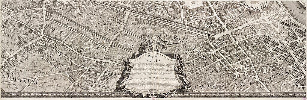
English: In marked contrast to the small, single-page city views appearing in late 16th and 17th century town atlases, were large, multi-sheet wall maps and birds eye views published during the 18th century. These richly detailed urban images depicted Europes largest and most important cities, such as London, Dublin, Rome, Vienna, and Paris. Displayed here is one page from a 20-sheet view of Paris, drawn from a birds eye perspective. Commissioned in 1734 by Michel Etienne Turgot, Prevot des Marchands (chief merchant or as we might say today, head of the chamber of commerce), this view was prepared by Louis Bretez, a sculptor, painter, and specialist in perspective. It took him five years to complete and publish this large-scale drawing of Frances capital city. Bretez constructed the drawing as if the city was being viewed from the northwest, looking southeast, with the Seine River running through the middle of his composition. He also places Éle de la Cité and Éle St. Louis, the historic heart of the city, near the center of the image. The twenty sheets are placed together create a dramatic wall map measuring approximately eight by ten feet. Such a presentation, as depicted in the composite reproduction displayed on the wall, captures the grandeur of the imperial city under the reign of Louis XV. Meanwhile, the exquisite detail which Bretez used to render individual buildings is evident in the atlas plate displayed below. |
||||||||||||||||||||||||||||||||||||||
| Fecha | |||||||||||||||||||||||||||||||||||||||
| Fuente | Norman B. Leventhal Map Center | ||||||||||||||||||||||||||||||||||||||
| Creador |
Cartógrafo :
Grabador :
|
||||||||||||||||||||||||||||||||||||||
| Geotemporal data | |||||||||||||||||||||||||||||||||||||||
| Map location | Paris | ||||||||||||||||||||||||||||||||||||||
| Escala | Scale approximately 1:1,800 | ||||||||||||||||||||||||||||||||||||||
| Georeferencing | If inappropriate please set warp_status = skip to hide. | ||||||||||||||||||||||||||||||||||||||
| Bibliographic data | |||||||||||||||||||||||||||||||||||||||
| Map sheet | 18-19 | ||||||||||||||||||||||||||||||||||||||
| Lengua | French | ||||||||||||||||||||||||||||||||||||||
| Archival data | |||||||||||||||||||||||||||||||||||||||
| Colección |
|
||||||||||||||||||||||||||||||||||||||
| Número de inventario |
|
||||||||||||||||||||||||||||||||||||||
| Dimensiones | on sheet 63 x 90 cm | ||||||||||||||||||||||||||||||||||||||
| Técnica | 1 map | ||||||||||||||||||||||||||||||||||||||
| Inscripciones | dessiné et gravé sous les ordres de Messire Michel Etienne Turgot ... [et al.] ; levé et dessiné par Louis Bretez ; gravé par Claude Lucas ; et écrit par Aubin | ||||||||||||||||||||||||||||||||||||||

|
Licencia
[editar]
|
Este material está en dominio público en los demás países donde el derecho de autor se extiende por 100 años (o menos) tras la muerte del autor. | |
| Esta obra ha sido identificada como libre de las restricciones conocidas en virtud del derecho de autor, incluyendo todos los derechos conexos. | |
| Annotations | This image is annotated: View the annotations at Commons |
Historial del archivo
Haz clic sobre una fecha y hora para ver el archivo tal como apareció en ese momento.
| Fecha y hora | Miniatura | Dimensiones | Usuario | Comentario | |
|---|---|---|---|---|---|
| actual | 11:22 15 feb 2018 | 17 930 × 5850 (74,54 MB) | Paris 16 (discusión | contribs.) | ||
| 19:24 13 feb 2018 | 17 930 × 5850 (73,76 MB) | Paris 16 (discusión | contribs.) | |||
| 10:00 16 nov 2013 | 18 907 × 7125 (63,5 MB) | Paris 16 (discusión | contribs.) |
No puedes sobrescribir este archivo.
Usos del archivo
Las siguientes páginas usan este archivo:
- Turgot map of Paris
- User:Paris 16/Recent uploads/2018 February 14-16
- Commons:Featured picture candidates/Log/February 2018
- Commons:Featured picture candidates/removal/Set/Turgot map of Paris, Kyoto University Library
- Commons:Featured pictures/Non-photographic media/Maps
- Commons:Featured pictures/Sets
- File:Turgot Map of Paris - Norman B. Leventhal Map Center.jpg (archivo de redirección)
Uso global del archivo
Las wikis siguientes utilizan este archivo:
- Uso en af.wikipedia.org
- Uso en de.wikipedia.org
- Uso en en.wikipedia.org
- Wikipedia:WikiProject France
- Wikipedia:Featured pictures/Diagrams, drawings, and maps/Maps
- Norman B. Leventhal Map Center
- Wikipedia:WikiProject France/Article Status
- Wikipedia:WikiProject France/Featured and good content
- Turgot map of Paris
- Wikipedia:Featured pictures thumbs/62
- Wikipedia:Featured picture candidates/November-2018
- Wikipedia:Featured picture candidates/Turgot map of Paris
- Wikipedia:Featured picture candidates/January-2019
- Wikipedia:Featured picture candidates/Turgot map of Paris (2)
- User:Taksen/sandbox44
- Wikipedia:Picture of the day/July 2021
- Template:POTD/2021-07-14/18
- Rue Saint-Florentin, Paris
- Uso en es.wikipedia.org
- Uso en fr.wikipedia.org
- Uso en he.wikipedia.org
- Uso en lt.wikipedia.org
- Uso en mg.wikipedia.org
- Uso en ru.wikipedia.org
- Uso en uk.wikipedia.org