File:UBBasel Map Griechenland Ägäis 1569 Kartenslg Mappe 250-30d.tif
Jump to navigation
Jump to search

Size of this JPG preview of this TIF file: 767 × 600 pixels. Other resolutions: 307 × 240 pixels | 614 × 480 pixels | 982 × 768 pixels | 1,280 × 1,001 pixels | 2,560 × 2,002 pixels | 11,012 × 8,612 pixels.

Original file (11,012 × 8,612 pixels, file size: 271.35 MB, MIME type: image/tiff, 2 pages)
Captions
Captions
Add a one-line explanation of what this file represents
Summary
[edit]| Warning | The original file is very high-resolution. It might not load properly or could cause your browser to freeze when opened at full size. |
|---|
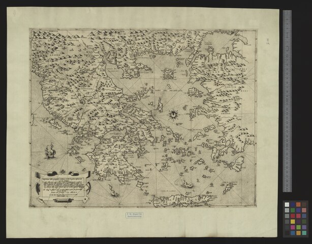
| Title |
Descritione della geographia moderna de tutta la Gretia insieme con l'uso del navigare |
|||||||||||||||||||||||
| Description |
Descritione della geographia moderna de tutta la Gretia insieme con l'uso del navigare / opera di Iacomo Gastaldo cosmografa ; Donato Bertello ; Dnco. Z.F. |
|||||||||||||||||||||||
| Date | ||||||||||||||||||||||||
| Source | 10.3931/e-rara-13968 : Info: Kartenportal.CH | |||||||||||||||||||||||
| Creator |
Jacobo Gastaldi Donato Bertelli Domenico Zenoi |
|||||||||||||||||||||||
| Permission (Reusing this file) |
|
|||||||||||||||||||||||
| Geotemporal data | ||||||||||||||||||||||||
| Map location | Griechenland / Ägäis | |||||||||||||||||||||||
| Scale | Ca. 1:2 400 000 | |||||||||||||||||||||||
| Bounding box |
|
|||||||||||||||||||||||
| Georeferencing | If inappropriate please set warp_status = skip to hide. | |||||||||||||||||||||||
| Bibliographic data | ||||||||||||||||||||||||
| Language | ita | |||||||||||||||||||||||
| Printed by |
Venetia, s.n. |
|||||||||||||||||||||||
| Archival data | ||||||||||||||||||||||||
| Collection |
|
|||||||||||||||||||||||
| Accession number |
Basel UB, Kartenslg Mappe 250:30d |
|||||||||||||||||||||||
| Dimensions | height: 40 cm (15.7 in); width: 50 cm (19.6 in) | |||||||||||||||||||||||
| Medium | Kupferstich | |||||||||||||||||||||||
| Notes | Titelkartusche unten links / Massstab in graph. Form ("Scala di miglia") / Kompassrose rechts der Mitte / Dnco. Z.F. steht für Domenico Zenoi fecit | |||||||||||||||||||||||


File history
Click on a date/time to view the file as it appeared at that time.
| Date/Time | Thumbnail | Dimensions | User | Comment | |
|---|---|---|---|---|---|
| current | 17:46, 18 August 2015 |  | 11,012 × 8,612, 2 pages (271.35 MB) | Basel University Library (talk | contribs) | GWToolset: Creating mediafile for Basel University Library. |
You cannot overwrite this file.
File usage on Commons
The following page uses this file: