File:University of Reading War Memorial.jpg
跳至導覽
跳至搜尋

預覽大小:450 × 600 像素。 其他解析度:180 × 240 像素 | 480 × 640 像素。
原始檔案 (480 × 640 像素,檔案大小:183 KB,MIME 類型:image/jpeg)
說明
說明
添加單行說明來描述出檔案所代表的內容
摘要[編輯]
| 描述 |
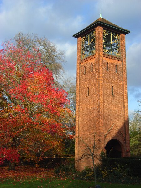
English: The Herbert Maryon-designed University War Memorial, on the London Road Campus of the University of Reading. The First World War memorial takes the form of a clock tower with the dates 1914 and 1918 incorporated into the clock. The names of the fallen are listed inside the building. |
| 日期 | 攝於2008年11月18日 |
| 來源 | www.geograph.org.uk. |
| 作者 | Andrew Smith |
| 授權許可 (重用此檔案) |
Published under Creative Commons Attribution-Sharealike 2.0 |
| 姓名標示 (由许可协议要求) | Andrew Smith / University War Memorial, Reading / |
| 目標地點 | | 位於此地的本圖片與其他圖片: OpenStreetMap |
|---|
授權條款[編輯]

|
此檔案採用創用CC 姓名標示-相同方式分享 2.0 通用版授權條款。
姓名標示: Andrew Smith
- 您可以自由:
- 分享 – 複製、發佈和傳播本作品
- 重新修改 – 創作演繹作品
- 惟需遵照下列條件:
- 姓名標示 – 您必須指名出正確的製作者,和提供授權條款的連結,以及表示是否有對內容上做出變更。您可以用任何合理的方式來行動,但不得以任何方式表明授權條款是對您許可或是由您所使用。
- 相同方式分享 – 如果您利用本素材進行再混合、轉換或創作,您必須基於如同原先的相同或兼容的條款,來分布您的貢獻成品。
|
此作品的攝影複製受英國法律保護(1988年著作權、設計及專利法第六十二條),其中規定永久位於公共場所或向公眾開放的場所拍攝建築物、雕塑、建築物模型或藝術工藝作品的照片不構成侵權。這不適用於平面圖形作品,例如海報或壁畫。有關更多資訊,請參閱這裡。
|
檔案歷史
點選日期/時間以檢視該時間的檔案版本。
| 日期/時間 | 縮圖 | 尺寸 | 使用者 | 備註 | |
|---|---|---|---|---|---|
| 目前 | 2008年12月5日 (五) 17:16 | | 480 × 640(183 KB) | Chris j wood(留言 | 貢獻) | ==Summary== {{Information| |Description = The University War Memorial, on the London Road Campus of the University of Reading. The First World War memorial takes the form of a clock tower with the dates 1914 and 1918 incorporated into the clock. The names |
無法覆蓋此檔案。
檔案用途
全域檔案使用狀況
以下其他 wiki 使用了這個檔案:
- azb.wikipedia.org 的使用狀況
- en.wikipedia.org 的使用狀況
- Red brick university
- University of Reading
- Wantage Hall
- Museum of English Rural Life
- Harris Garden
- Ure Museum of Greek Archaeology
- Cole Museum of Zoology
- Foxhill House
- Whiteknights Park
- Bulmershe Court
- Region 6 War Room
- London Road Campus
- University of Reading Herbarium
- Greenlands, Buckinghamshire
- Henley Business School
- ICMA Centre
- University of Reading Atmospheric Observatory
- The Spark (newspaper)
- Template:University of Reading
- Category:Buildings and structures of the University of Reading
- Percy Ure
- List of halls of residence at the University of Reading
- Herbert Maryon
- National Centre for Biotechnology Education
- Reading University Boat Club
- Wikipedia:Did you know/Statistics/Monthly DYK pageview leaders/2018
- List of University of Reading alumni
- Annie Ure
- University of Reading War Memorial
- Template:Did you know nominations/University of Reading War Memorial
- Wikipedia:Recent additions/2018/December
- Wikipedia:Main Page history/2018 November 30
- List of public art in Reading, Berkshire
- Works of Herbert Maryon
- Template:List of public art in Reading, Berkshire
- Wikipedia:Did you know/Statistics/Monthly DYK pageview leaders/2018/November
- it.wikipedia.org 的使用狀況
- ms.wikipedia.org 的使用狀況
- sv.wikipedia.org 的使用狀況
- tl.wikipedia.org 的使用狀況
- www.wikidata.org 的使用狀況
- wuu.wikipedia.org 的使用狀況
- zh.wikipedia.org 的使用狀況