File:Up and down the field - geograph.org.uk - 982780.jpg
Jump to navigation
Jump to search
No higher resolution available.
Up_and_down_the_field_-_geograph.org.uk_-_982780.jpg (640 × 480 pixels, file size: 136 KB, MIME type: image/jpeg)
Captions
Captions
Add a one-line explanation of what this file represents
Summary
[edit]| Description |
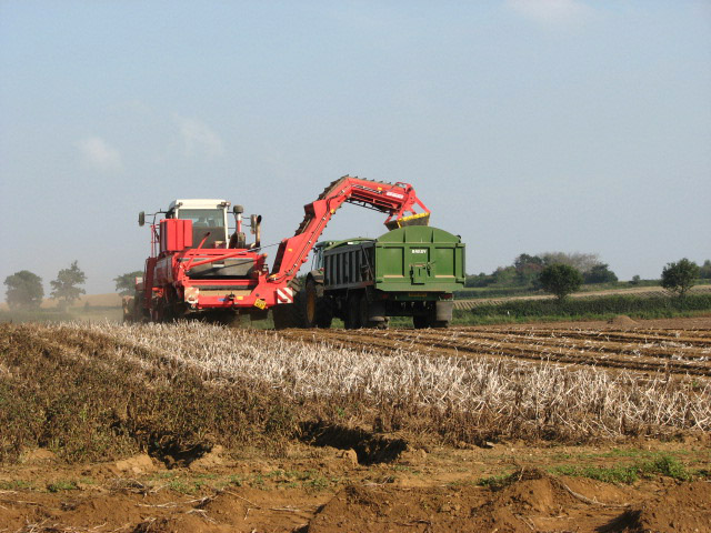
English: Up and down the field. – After turning around at the end of the just harvested ridges the machines soon realign themselves once again to resume their task, this time headed in the opposite direction. What at first glance looks like stubble are the dried remains of flailed potato vines. On maturity of the tubers the potato vines are killed in order to terminate growth and hence control tuber size, and to set skin, which reduces skinning and bruising during harvest, and shrinkage in storage. The most common method of vine killing is chemical desiccation. Sometimes a flail vine shredder (982636, 982683) is used, an implement consisting of varying knife lengths to accommodate the contours of the hill and furrow, producing a very rapid vine kill by mechanically removing all but about 15 centimetres of the vines which are then removed by chemical desiccation. – The crop is now ready for harvesting and a root crop harvester (red) can be seen working in tandem with a trailer-pulling tractor (green). Most potato harvesters operate by cutting through the ground with a digger blade and forcing the dirt and potatoes over a series of chains that transport the potatoes while removing the dirt and vines. The potatoes are elevated by the chains and other conveyers so that they can reach a sufficient height to be dumped into a truck or trailer and hauled away. This process requires constant cooperation between the harvester and the tractor running side by side. |
||
| Date | |||
| Source | geograph.org.uk | ||
| Author | Evelyn Simak | ||
| Permission (Reusing this file) |
This file is licensed under the Creative Commons Attribution-Share Alike 2.0 Generic license. Attribution: Evelyn Simak
|
||
| Other versions |
|
||
| Attribution (required by the license) | Evelyn Simak / Up and down the field / | ||


| Camera location | | View this and other nearby images on: OpenStreetMap |
|---|
_heading:90.00&language=en)
| Object location | | View this and other nearby images on: OpenStreetMap |
|---|
_heading:90.00&language=en)
File history
Click on a date/time to view the file as it appeared at that time.
| Date/Time | Thumbnail | Dimensions | User | Comment | |
|---|---|---|---|---|---|
| current | 02:16, 23 February 2011 | | 640 × 480 (136 KB) | GeographBot (talk | contribs) | == {{int:filedesc}} == {{Information |description={{en|1=Up and down the field After turning around at the end of the just harvested ridges the machines soon realign themselves once again to resume their task, this time headed in the opposite direction. |
You cannot overwrite this file.
File usage on Commons
The following 4 pages use this file: