File:Vandenberg Space Force Base imaged by KH-9.1 on 1971-06-17.jpg

Original file (22,012 × 4,411 pixels, file size: 55.75 MB, MIME type: image/jpeg)
Captions
Captions
Summary
[edit]
| Warning | The original file is very high-resolution. It might not load properly or could cause your browser to freeze when opened at full size. |
|---|
| Description |
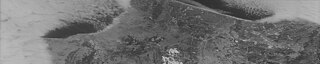
Vandenberg Space Force Base imaged by KH-9.1 on 1971-06-17 at a ~0.6m/2ft - ~1.2m/4ft resolution. Full TIFF files download (8.95 GB) from USGS: <a href="https://dds.cr.usgs.gov/download-staging/eyJpZCI6MTI5OTg4MDAzLCJjb250YWN0SWQiOjI2MDY0NjA0fQ==" rel="noreferrer nofollow">dds.cr.usgs.gov/download-staging/eyJpZCI6MTI5OTg4MDAzLCJj...</a> Sometimes these download links can be temperamental, so patience may be needed. Entity ID: D3C1201-100017A059 Acquisition Date: 1971/06/17 Mission: 1201-1 Frame Number: 59 Image Type: Black and White Camera: A Camera Resolution: 2 to 4 feet Film Type: 6 Generation: 2 Polarity: Positive Operations Number: 17 |
| Date | |
| Source | D3C1201-100017A059_o |
| Author | Scanned Declassified Spy Satellite Imagery |
| Camera location | | View this and other nearby images on: OpenStreetMap |
|---|
Licensing
[edit]
| This work originally came from a National Reconnaissance Office (NRO) website or publication and has been specifically released into the public domain in the United States. Unless specifically released, NRO information should be assumed to be classified. The NRO seal is usage-restricted. See the site policy security notice and the site policy copyright notice for more information. Please note that if a copyright is indicated on a photo, graphic, or any other material, permission to copy these materials must be obtained from the original source.[1] |

|
This image is in the public domain in the United States because it only contains materials that originally came from the United States Geological Survey, an agency of the United States Department of the Interior. For more information, see the official USGS copyright policy.
|
| This image, originally posted to Flickr, was reviewed on 31 March 2024 by the administrator or reviewer MGA73, who confirmed that it was available on Flickr under the stated license on that date. |
File history
Click on a date/time to view the file as it appeared at that time.
| Date/Time | Thumbnail | Dimensions | User | Comment | |
|---|---|---|---|---|---|
| current | 13:23, 20 February 2022 | 22,012 × 4,411 (55.75 MB) | Don-vip (talk | contribs) | Cropped 9 % horizontally, 6 % vertically using CropTool with lossless mode. | |
| 12:38, 17 February 2022 | 24,240 × 4,708 (63.46 MB) | Don-vip (talk | contribs) | Transferred from Flickr via #flickr2commons |
You cannot overwrite this file.
File usage on Commons
The following 2 pages use this file:
- File:D3C1201-100017A059 o (51836167420).jpg (file redirect)
- File:Vandenberg Space Force Base imaged by KH-9.1 on 1971-06-17 - D3C1201-100017A059.jpg (file redirect)
.jpg&redirect=no)