File:Venice Lagoon December 9 2001.jpg
Siirry navigaatioon
Siirry hakuun
Tämän esikatselun koko: 512 × 599 kuvapistettä. Muut resoluutiot: 205 × 240 kuvapistettä | 410 × 480 kuvapistettä | 656 × 768 kuvapistettä | 875 × 1 024 kuvapistettä | 1 750 × 2 048 kuvapistettä | 3 580 × 4 189 kuvapistettä.
Alkuperäinen tiedosto (3 580 × 4 189 kuvapistettä, 11,35 MiB, MIME-tyyppi: image/jpeg)
Kuvatekstit
Kuvatekstit
Lisää yhden rivin pituinen kuvaus tästä tiedostosta
Yhteenveto[muokkaa]
| Kuvaus |
Deutsch: Dieses Satellitenbild der Lagune von Venedig wurde von ASTER (Advanced Spaceborne Thermal Emission and Reflection Radiometer) aufgenommen, einem Aufnahmesystem an Bord des Satelliten Terra der Teil des NASA Earth Observing System (EOS) ist. Das Bild wurde am 9. Dezember 2001 erstellt und deckt eine Fläche von 39 x 35 km ab. (Simulierte Naturfarben)
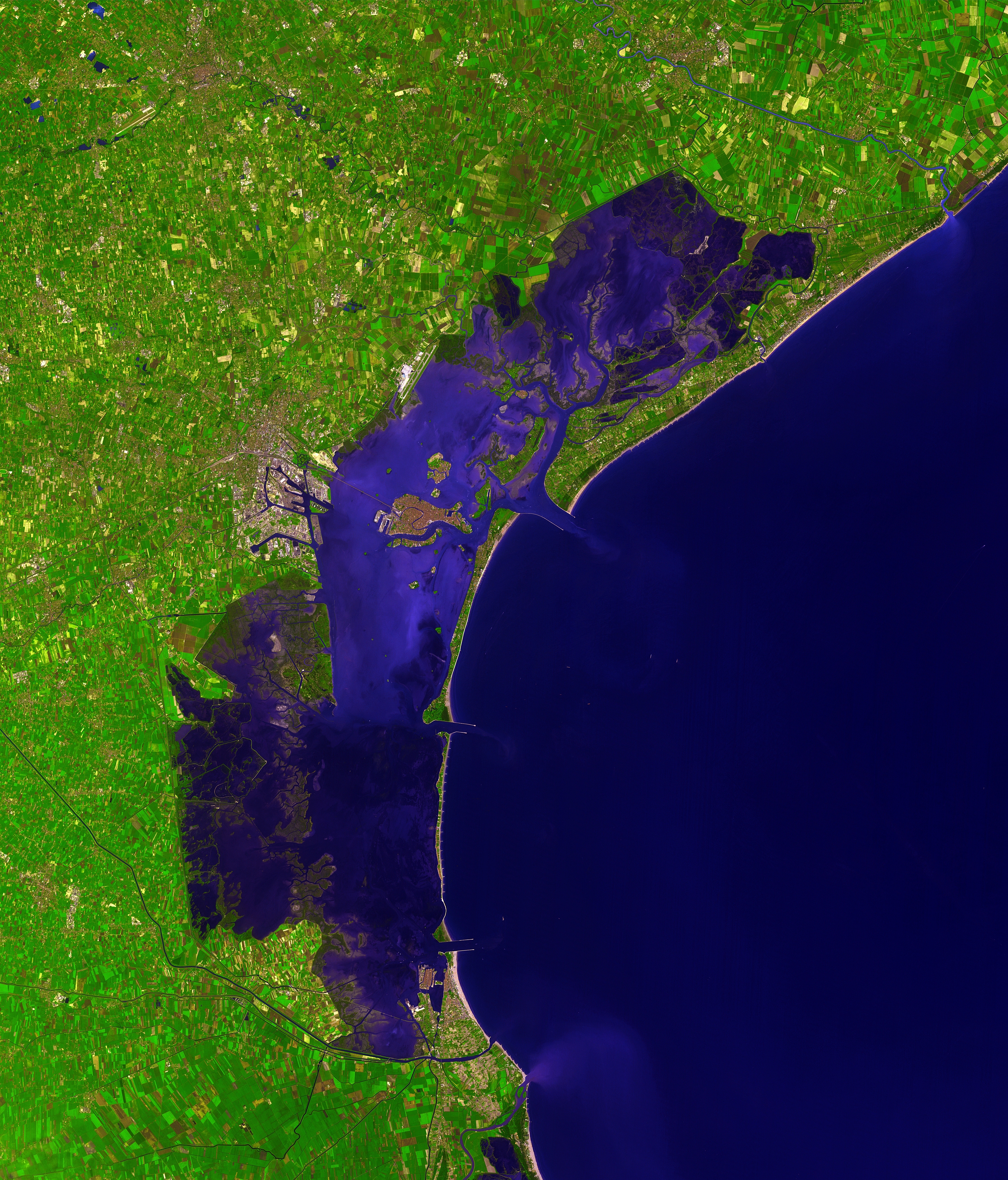
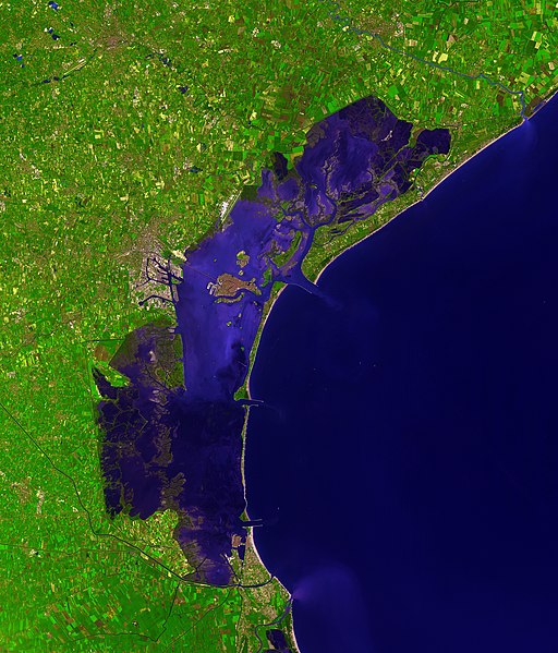
English: This picture of the Venetian Lagoon was taken by ASTER (Advanced Spaceborne Thermal Emission and Reflection Radiometer), an imaging instrument flying on Terra, a satellite part of NASA's Earth Observing System (EOS). It covers an area of 39 x 35 km and was acquired on December 9, 2001. (simulated natural color)
Français : Image de la lagune de Venise prise par l'instrument d'imagerie ASTER (Advanced Spaceborne Thermal Emission and Reflection Radiometer) embarqué sur le satellite Terra, lancé dans le cadre du programme EOS (Earth Observing System, ou Système d'Observation de la Terre). Aire couverte: 39 x 35 km, Couleurs naturelles simulées. Image prise le 9 décembre 2001.
Italiano: Questa immagine della Laguna di Venezia è stata ripresa da ASTER (Advanced Spaceborne Thermal Emission and Reflection Radiometer), uno strumento installato su Terra, un satellite della NASA Earth Observing System (EOS). Copre un'area di 39 x 35 km ed è stata ripresa il 9 dicembre 2001. (colori naturali simulati) |
| Päiväys | |
| Lähde | http://earthobservatory.nasa.gov/Newsroom/NewImages/images.php3?img_id=16314 |
| Tekijä | NASA/GSFC/MITI/ERSDAC/JAROS, and U.S./Japan ASTER Science Team |
| Muut versiot |
 |
| Kameran sijainti | | Tämä ja muut kuvat kartalla: OpenStreetMap |
|---|
|

Tämä kuva valittiin päivän kuvaksi 15. syyskuuta 2007. Sen kuvaus oli seuraavanlainen: English: Satellite photo of the Venetian Lagoon. Päivän kuva:
Asturianu: Semeya satelital de la Llaguna de Venecia Deutsch: Satellitenbild der Lagune von Venedig English: Satellite photo of the Venetian Lagoon. Español: Fotografía de satélite de la laguna de Venecia. Euskara: Veneziako badia satelitetik ikusia Français : La lagune de Venise vue par satellite Íslenska: Gervihnattamynd af Feneyjalóni. Italiano: Foto satellitare della laguna di Venezia. Magyar: A velencei lagúna műholdas képe (39 x 35 km-es terület, szinezve, 2001. december 9.) Беларуская: Венецыянская лагуна, здымак з космасу. Русский: Венецианская лагуна, снимок из космоса |
Lisenssi[muokkaa]
| Tämä teos on ilman tekijänoikeuden suojaa, koska National Aeronautics and Space Administration (NASA) loi sen. Koska Nasa on Yhdysvaltain liittovaltion organisaatio, sen luomat teokset ovat ilman tekijänoikeuden suojaa. ([1][2]) | ||
 |
Varoitukset:
|
| Annotations | This image is annotated: View the annotations at Commons |

Tiedoston historia
Päiväystä napsauttamalla näet, millainen tiedosto oli kyseisellä hetkellä.
| Päiväys | Pienoiskuva | Koko | Käyttäjä | Kommentti | |
|---|---|---|---|---|---|
| nykyinen | 7. joulukuuta 2006 kello 15.41 | | 3 580 × 4 189 (11,35 MiB) | AlMare (keskustelu | muokkaukset) | Cropped |
| 13. marraskuuta 2006 kello 11.46 |  | 3 598 × 4 200 (11,09 MiB) | AlMare (keskustelu | muokkaukset) | ||
| 10. marraskuuta 2006 kello 14.14 |  | 3 598 × 4 200 (8,42 MiB) | AlMare (keskustelu | muokkaukset) | {{en|This picture of the en:Venetian Lagoon was taken by ASTER (Advanced Spaceborne Thermal Emission and Reflection Radiometer), an imaging instrument flying on Terra, a satellite part of NASA's Earth Observing System |
Et voi tallentaa uutta tiedostoa tämän tilalle.
Tiedoston käyttö
Seuraavat 50 sivua käyttävät tätä tiedostoa:
- Featured Photographs in the Public Domain
- User:AlMare/gallery
- User:Dschwen/FP2006
- User talk:AlMare/Archive 1
- Commons:Featured picture candidates/Image:Venice Lagoon December 9 2001.jpg
- Commons:Featured picture candidates/Log/December2006
- Commons:Featured pictures/Places/Satellite images
- Commons:Featured pictures/chronological/2006-B
- Commons:Picture of the Year/2006/gallery
- Commons:Picture of the Year/2006/gallery0
- Commons:Picture of the Year/2006/gallery large
- Commons:Potd/2007-09 (de)
- Commons:Potd/2007-09 (eo)
- Commons:Potd/2007-09 (fr)
- Commons:Potd/2007-09 (nl)
- Commons:Potd/2007-09 (pl)
- Commons:Potd/2007-09 (pt)
- Commons:Potd/2007-09 (ro)
- Commons:Potd/2007-09 (ru)
- Commons:Potd/2007-09 (tr)
- Commons:Potd/2007-09 (uk)
- Commons:Potd/2007-09 (zh-hant)
- Commons talk:Featured picture candidates/Archive candidate list
- Template:Potd/2007-09
- Template:Potd/2007-09-15
- Template:Potd/2007-09-15 (ast)
- Template:Potd/2007-09-15 (be)
- Template:Potd/2007-09-15 (cs)
- Template:Potd/2007-09-15 (de)
- Template:Potd/2007-09-15 (en)
- Template:Potd/2007-09-15 (es)
- Template:Potd/2007-09-15 (eu)
- Template:Potd/2007-09-15 (fr)
- Template:Potd/2007-09-15 (gl)
- Template:Potd/2007-09-15 (hu)
- Template:Potd/2007-09-15 (is)
- Template:Potd/2007-09-15 (it)
- Template:Potd/2007-09-15 (ja)
- Template:Potd/2007-09-15 (nl)
- Template:Potd/2007-09-15 (pam)
- Template:Potd/2007-09-15 (pl)
- Template:Potd/2007-09-15 (pt)
- Template:Potd/2007-09-15 (ru)
- Template:Potd/2007-09-15 (sv)
- Template:Potd/2007-09-15 (zh-hans)
- Template:Potd/2007-09-15 (zh-hant)
- Template:Potd/2007-09 (zh-hans)
- Category:Defense system of the Venice Lagoon
- Category:Lagoons
- Category:Satellite imagery
Tiedoston järjestelmänlaajuinen käyttö
Seuraavat muut wikit käyttävät tätä tiedostoa:
- Käyttö kohteessa ar.wikipedia.org
- Käyttö kohteessa ast.wikipedia.org
- Käyttö kohteessa ba.wikipedia.org
- Käyttö kohteessa be.wikipedia.org
- Käyttö kohteessa bg.wikipedia.org
- Käyttö kohteessa bn.wikipedia.org
- Käyttö kohteessa bn.wikibooks.org
- Käyttö kohteessa br.wikipedia.org
- Käyttö kohteessa ca.wikipedia.org
- Käyttö kohteessa cs.wikipedia.org
- Käyttö kohteessa cy.wikipedia.org
- Käyttö kohteessa de.wikipedia.org
- Käyttö kohteessa de.wiktionary.org
- Käyttö kohteessa el.wikipedia.org
- Käyttö kohteessa en.wikipedia.org
- Käyttö kohteessa en.wiktionary.org
- Käyttö kohteessa eo.wikipedia.org
- Käyttö kohteessa eo.wikivoyage.org
- Käyttö kohteessa et.wikipedia.org
- Käyttö kohteessa fa.wikibooks.org
- Käyttö kohteessa fi.wikipedia.org
- Käyttö kohteessa fi.wiktionary.org
- Käyttö kohteessa frr.wikipedia.org
- Käyttö kohteessa fr.wikipedia.org
- Käyttö kohteessa fy.wikipedia.org
- Käyttö kohteessa gl.wikipedia.org
- Käyttö kohteessa hi.wikipedia.org
- Käyttö kohteessa hr.wikipedia.org
- Käyttö kohteessa hu.wikipedia.org
Näytä lisää tämän tiedoston järjestelmänlaajuista käyttöä.