File:Viaduc de l'escargot (DPJ - bpt6k6491661q f50).jpg
Jump to navigation
Jump to search

Size of this preview: 755 × 600 pixels. Other resolutions: 302 × 240 pixels | 605 × 480 pixels | 967 × 768 pixels | 1,280 × 1,017 pixels | 2,560 × 2,033 pixels | 2,701 × 2,145 pixels.
Original file (2,701 × 2,145 pixels, file size: 1.65 MB, MIME type: image/jpeg)
Captions
Captions
Add a one-line explanation of what this file represents
Summary
[edit].jpg&action=edit§ion=1)
| Description |
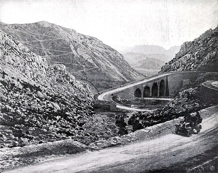
English: View of the " viaduct of the snail " or " viaduct of the Col Saint Louis ", located in the commune of Caudiès-de-Fenouillèdes in the department of Pyrénées-Orientales (France). The spiral design is carried out by the engineer of Ponts et Chaussées: Étienne Raymond Amiel (1752-1832) and continued by the chief engineer `` Rabourdin following the meeting of the General Council of the Pyrénées Orientales during his meeting of August 26, 1843.
Español: Vista del " viaducto del caracol " o " viaducto del Col Saint Louis ", ubicado en la comuna de Caudiès-de-Fenouillèdes en el departamento de Pirineos Orientales (Francia). El diseño de la espiral es realizado por el ingeniero de Ponts et Chaussées: Étienne Raymond Amiel (1752-1832) y continuado por el ingeniero jefe `` Rabourdin tras la reunión del Consejo General de los Pirineos Orientales durante su reunión reunión del 26 de agosto de 1843.
Français : Vue du « viaduc de l'escargot » ou « viaduc du col Saint Louis », situé sur la commune de Caudiès-de-Fenouillèdes dans le département des Pyrénées-Orientales (France). La conception en colimaçon est réalisée par l'ingénieur des Ponts et Chaussées : Étienne Raymond Amiel (1752-1832) et continuée par l'ingénieur en chef Rabourdin suite à la réunion du conseil Général des Pyrénées Orientales au cours de sa séance du 26 août 1843.
References : |
||
| Date |
circa 1900
|
||
| Source |
|
||
| Author | Unknown author |
| Object location | | View this and other nearby images on: OpenStreetMap |
|---|
.jpg¶ms=042.828658_N_0002.338714_E_globe:Earth_class:object_type:object_region:FR_&language=en)
| This is a retouched picture, which means that it has been digitally altered from its original version. Modifications: Reduction of saturation, cropping. A bit sharpening. With GIMP.
|
Licensing
[edit].jpg&action=edit§ion=2)
| Previous public domain rationale, no longer applicable | ||
|---|---|---|
|
File history
Click on a date/time to view the file as it appeared at that time.
| Date/Time | Thumbnail | Dimensions | User | Comment | |
|---|---|---|---|---|---|
| current | 21:26, 25 July 2021 | | 2,701 × 2,145 (1.65 MB) | DePlusJean (talk | contribs) | Uploaded a work by {{unknown|author}} from {{Gallica|1=bpt6k6491661q}} with UploadWizard |
You cannot overwrite this file.
File usage on Commons
There are no pages that use this file.
File usage on other wikis
The following other wikis use this file:
- Usage on fr.wikipedia.org
.jpg&oldid=648058988)