File:Vietnam (1069).png
(Redirected from File:Vietnam (1100 AD).png)
.png&redirect=no)
Size of this preview: 721 × 599 pixels. Other resolutions: 289 × 240 pixels | 577 × 480 pixels | 860 × 715 pixels.
Original file (860 × 715 pixels, file size: 51 KB, MIME type: image/png)
Captions
Captions
Add a one-line explanation of what this file represents
Summary[edit]
.png&action=edit§ion=1)
| Description |
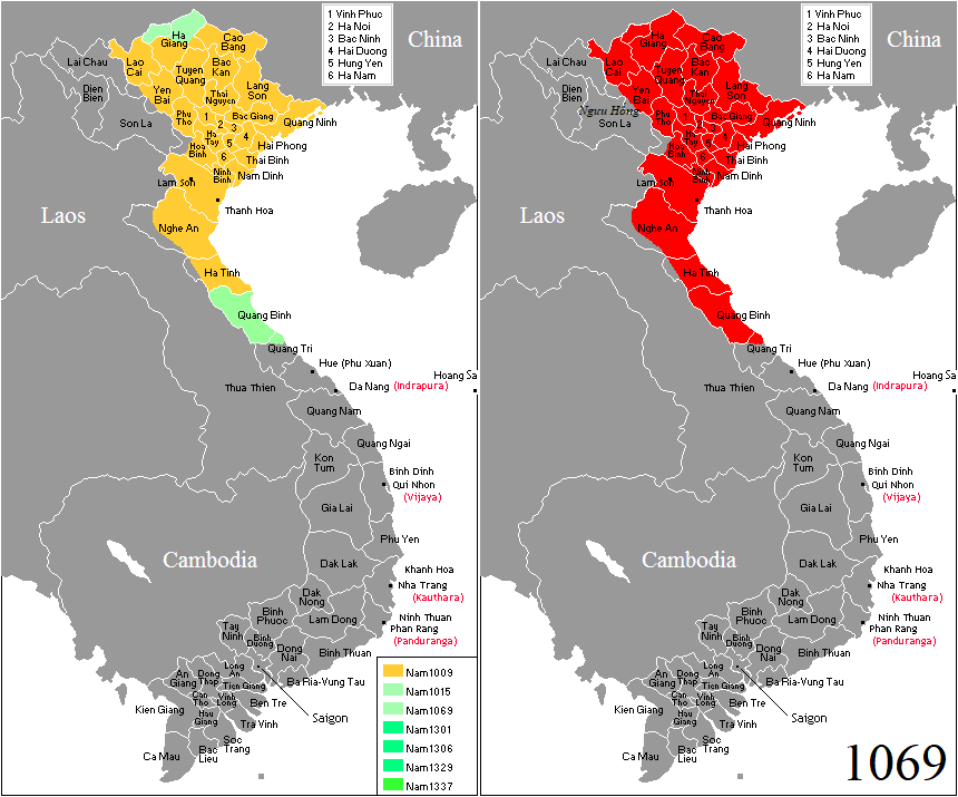
English: Vietnam in 1069. |
| Date | |
| Source | Own work |
| Author | Night Lantern |
| Permission (Reusing this file) |
This file is licensed under the Creative Commons Attribution-Share Alike 3.0 Unported license.
|
File history
Click on a date/time to view the file as it appeared at that time.
.png&dir=prev)
.png&offset=20190103133301)
.png&offset=&limit=20)
.png&offset=&limit=50)
.png&offset=&limit=100)
.png&offset=&limit=250)
.png&offset=&limit=500)
| Date/Time | Thumbnail | Dimensions | User | Comment | |
|---|---|---|---|---|---|
| current | 06:41, 25 February 2019 | | 860 × 715 (51 KB) | Doãn Hiệu (talk | contribs) | thêm địa danh |
| 01:55, 10 February 2019 |  | 860 × 715 (47 KB) | Doãn Hiệu (talk | contribs) | sửa biên giới tây Nghệ An. | |
| 02:33, 7 February 2019 |  | 860 × 715 (47 KB) | Doãn Hiệu (talk | contribs) | Điều chỉnh biên giới miền tây xứ Nghệ: thời nhà Lý chưa có phủ Trà Lân, Ngọc Ma (Tương Dương, Con Quông, Hương Sơn). | |
| 06:40, 6 February 2019 |  | 860 × 715 (47 KB) | Doãn Hiệu (talk | contribs) | Điều chỉnh biên giới phía tây bắc thời nhà Lý: Vùng Bát Xát, Lào Cai là châu Thủy Vĩ theo Đào Duy Anh châu Thủy Vĩ thời Lý là đất Băng Châu của Đại Việt, huyện Văn Bàn và Văn Chấn là đất Đặng Châu Đại Việt. Nghĩa Lộ (Mường Lò), Than Uyên (Mường Than) là đất của các bộ tộc người Thái Đen và Thái Trắng, trong đó Mường Lò theo Quam-to-muong là đất bàn ban đầu người Thái Đen chinh phục tây bắc lập nên tiểu quốc Ngưu Hống vào thế kỷ 10 ở Tây bắc. Điều chỉnh biên giới phía nam Đại Việt năm 1069: Vũ... | |
| 06:02, 6 February 2019 |  | 428 × 713 (29 KB) | Night Lantern (talk | contribs) | one frame per each frame part, two frame is for the main map | |
| 05:57, 6 February 2019 |  | 860 × 715 (47 KB) | Night Lantern (talk | contribs) | ah, sorry..nevermind | |
| 05:42, 6 February 2019 |  | 428 × 713 (19 KB) | Night Lantern (talk | contribs) | see previous comment | |
| 05:39, 6 February 2019 |  | 428 × 713 (29 KB) | Night Lantern (talk | contribs) | sorry to revert, but please upload in a new file since this image is solely used as part of the whole frame | |
| 03:55, 6 February 2019 |  | 860 × 715 (47 KB) | Doãn Hiệu (talk | contribs) | Chỉnh sửa biên giới tây bắc và biên giới phía nam. | |
| 13:33, 3 January 2019 |  | 428 × 713 (29 KB) | Doãn Hiệu (talk | contribs) | Điều chỉnh niên đại tiến trình. |
You cannot overwrite this file.
File usage on Commons
The following 2 pages use this file:
.gif)
File usage on other wikis
The following other wikis use this file:
- Usage on fr.wikipedia.org
.png&oldid=496623545)