File:Vile Vortices Map.png
Aller à la navigation
Aller à la recherche

Pas de plus haute résolution disponible.
Vile_Vortices_Map.png (696 × 291 pixels, taille du fichier : 414 kio, type MIME : image/png)
Légendes
Légendes
Ajoutez en une ligne la description de ce que représente ce fichier
Description[modifier]
| Description |
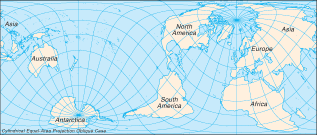
English: Map showing the approximate locations of the Vile Vortices. Français : Carte montrant les emplacements approximatifs des tourbillons géomagnétiques terrestres. |
| Date | 3 mars 2006 (date de téléversement originale) |
| Source | The Vile Vortice locations (shown in green) were added by the Wikipedia User. |
| Auteur | Kiwipat at en.wikipedia |
Conditions d’utilisation[modifier]
| Cette œuvre a été placée dans le domaine public par son auteur, Kiwipat sur Wikipédia anglais. Ceci s’applique dans le monde entier. Dans certains pays, ceci peut ne pas être possible ; dans ce cas : Kiwipat accorde à toute personne le droit d’utiliser cette œuvre dans n’importe quel but, sans aucune condition, sauf celles requises par la loi. |
| Cette image est une œuvre d'un employé de la Central Intelligence Agency, réalisée dans le cadre des tâches officielles de cette personne. En tant qu’œuvre du Gouvernement des États-Unis d'Amérique, ce document est placé dans le domaine public aux États-Unis d'Amérique.
|

|
Ce fichier, placé dans le domaine public lors de son importation, a été vérifié par l'administrateur ou l'utilisateur de confiance Magog the Ogre (talk) le 20 octobre 2011, qui a confirmé qu'il était dans le domaine public à cette date.
|
Journal des téléversements d’origine[modifier]
La page de description originale était ici. Tous les noms d'utilisateur qui suivent se rapportent à en.wikipedia.
Upload date | User | Bytes | Dimensions | Comment
- 2009-01-01 22:02 (UTC) | Kiwipat | 424342 (bytes) | 696×291 | best version
- 2009-01-01 20:44 (UTC) | Kiwipat | 45529 (bytes) | 635×272 |
- 2009-01-01 20:29 (UTC) | Kiwipat | 47421 (bytes) | 635×272 |
- 2006-03-03 00:58 (UTC) | Kiwipat | 27838 (bytes) | 635×272 | Map showing the approximate locations of the Vile Vortices. The original map is from the online Perry-Castañeda Library Map Collection. It is posted here courtesy of the University of Texas Libraries, The University of Texas at Austin. The Vile Vortice
Historique du fichier
Cliquer sur une date et heure pour voir le fichier tel qu'il était à ce moment-là.
| Date et heure | Vignette | Dimensions | Utilisateur | Commentaire | |
|---|---|---|---|---|---|
| actuel | 11 octobre 2011 à 10:00 | | 696 × 291 (414 kio) | SreeBot (d | contributions) | (Original text) : best version |
| 11 octobre 2011 à 10:00 |  | 635 × 272 (44 kio) | SreeBot (d | contributions) | ||
| 11 octobre 2011 à 10:00 |  | 635 × 272 (46 kio) | SreeBot (d | contributions) | ||
| 11 octobre 2011 à 10:00 |  | 635 × 272 (27 kio) | SreeBot (d | contributions) | (Original text) : Map showing the approximate locations of the Vile Vortices. The original map is from the online Perry-Castañeda Library Map Collection. It is posted here courtesy of the University of Texas Libraries, The University of Texas at Austin. |
Vous ne pouvez pas remplacer ce fichier.
Utilisations locales du fichier
Aucune page n’utilise ce fichier.
Utilisations du fichier sur d’autres wikis
Les autres wikis suivants utilisent ce fichier :
- Utilisation sur es.wikipedia.org
- Utilisation sur fi.wikipedia.org
- Utilisation sur fr.wikipedia.org
- Utilisation sur ro.wikipedia.org