File:Walton-on-the-Naze, The Naze Beacons - geograph.org.uk - 1477586.jpg
Jump to navigation
Jump to search
No higher resolution available.
Walton-on-the-Naze,_The_Naze_Beacons_-_geograph.org.uk_-_1477586.jpg (640 × 472 pixels, file size: 42 KB, MIME type: image/jpeg)
Captions
Captions
Add a one-line explanation of what this file represents
Summary[edit]
| Description |
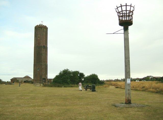
English: Walton-on-the-Naze: The Naze Beacons On the left is the 1720 brick built beacon constructed by Trinity House to line up with Walton Hall as a sighting guide to ships passing through the Goldmer Gap in the nearby shoals. It is 81 feet or about 25 metres high, once 90 feet high, and is the highest unlit beacon in the British Isles. Using the scrolling co-ordinates on the satellite imagery of the "Where's the Path?" website the distance between the plinth of the tower and the nearest point at the top of the rapidly (in geological terms) eroding and collapsing cliffs is no more than 50 metres. So the distance to the nearest cliff top is about double the height of the tower.
On the right is what I assume is a Millennium beacon. |
| Date | |
| Source | From geograph.org.uk |
| Author | Nigel Cox |
| Attribution (required by the license) | Nigel Cox / Walton-on-the-Naze: The Naze Beacons / |
| Camera location | | View this and other nearby images on: OpenStreetMap |
|---|
_heading:180.00&language=en)
| Object location | | View this and other nearby images on: OpenStreetMap |
|---|
_heading:180.00&language=en)
Licensing[edit]

|
This image was taken from the Geograph project collection. See this photograph's page on the Geograph website for the photographer's contact details. The copyright on this image is owned by Nigel Cox and is licensed for reuse under the Creative Commons Attribution-ShareAlike 2.0 license.
|
This file is licensed under the Creative Commons Attribution-Share Alike 2.0 Generic license.
Attribution: Nigel Cox
- You are free:
- to share – to copy, distribute and transmit the work
- to remix – to adapt the work
- Under the following conditions:
- attribution – You must give appropriate credit, provide a link to the license, and indicate if changes were made. You may do so in any reasonable manner, but not in any way that suggests the licensor endorses you or your use.
- share alike – If you remix, transform, or build upon the material, you must distribute your contributions under the same or compatible license as the original.
File history
Click on a date/time to view the file as it appeared at that time.
| Date/Time | Thumbnail | Dimensions | User | Comment | |
|---|---|---|---|---|---|
| current | 13:26, 2 March 2011 | 640 × 472 (42 KB) | GeographBot (talk | contribs) | == {{int:filedesc}} == {{Information |description={{en|1=Walton-on-the-Naze: The Naze Beacons On the left is the 1720 brick built beacon constructed by Trinity House to line up with Walton Hall as a sighting guide to ships passing through the Goldmer Gap |
You cannot overwrite this file.
File usage on Commons
There are no pages that use this file.