File:Water Cisterns - geograph.org.uk - 1105292.jpg
Jump to navigation
Jump to search
No higher resolution available.
Water_Cisterns_-_geograph.org.uk_-_1105292.jpg (640 × 482 pixels, file size: 170 KB, MIME type: image/jpeg)
Captions
Captions
Add a one-line explanation of what this file represents
Summary[edit]
| Description |
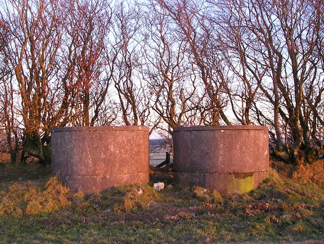
English: Water Cisterns These two cisterns are situated at the highest point of the farm. Water from the mains keeps them full. The water then flows by gravity to water troughs in other parts of the farm. Between the cisterns you can catch a glimpse of the higher land beyond Pencader. |
| Date | |
| Source | From geograph.org.uk |
| Author | Marion Phillips |
| Attribution (required by the license) | Marion Phillips / Water Cisterns / |
| Camera location | | View this and other nearby images on: OpenStreetMap |
|---|
_heading:112.00&language=en)
| Object location | | View this and other nearby images on: OpenStreetMap |
|---|
_heading:112.00&language=en)
Licensing[edit]

|
This image was taken from the Geograph project collection. See this photograph's page on the Geograph website for the photographer's contact details. The copyright on this image is owned by Marion Phillips and is licensed for reuse under the Creative Commons Attribution-ShareAlike 2.0 license.
|
This file is licensed under the Creative Commons Attribution-Share Alike 2.0 Generic license.
Attribution: Marion Phillips
- You are free:
- to share – to copy, distribute and transmit the work
- to remix – to adapt the work
- Under the following conditions:
- attribution – You must give appropriate credit, provide a link to the license, and indicate if changes were made. You may do so in any reasonable manner, but not in any way that suggests the licensor endorses you or your use.
- share alike – If you remix, transform, or build upon the material, you must distribute your contributions under the same or compatible license as the original.
File history
Click on a date/time to view the file as it appeared at that time.
| Date/Time | Thumbnail | Dimensions | User | Comment | |
|---|---|---|---|---|---|
| current | 19:28, 24 February 2011 | | 640 × 482 (170 KB) | GeographBot (talk | contribs) | == {{int:filedesc}} == {{Information |description={{en|1=Water Cisterns These two cisterns are situated at the highest point of the farm. Water from the mains keeps them full. The water then flows by gravity to water troughs in other parts of the farm. Be |
You cannot overwrite this file.
File usage on Commons
There are no pages that use this file.