File:Weston Lock on the Trent and Mersey Canal, Derbyshire - geograph.org.uk - 1612463.jpg
Weston_Lock_on_the_Trent_and_Mersey_Canal,_Derbyshire_-_geograph.org.uk_-_1612463.jpg (640 × 513 pixels, file size: 153 KB, MIME type: image/jpeg)
Captions
Captions
Summary
[edit]
| Description |
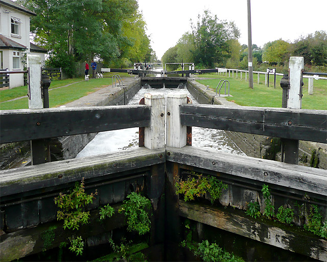
English: Weston Lock on the Trent and Mersey Canal, Derbyshire Weston Lock (No 4) is wide enough for two narrowboats to use together. The change of water level in this lock is almost eleven feet (3.3 metres) so it can be a daunting experience, especially if only one boat is coming up and lock paddles are not operated carefully. In this picture the lock is almost full. All ground and gate paddles are up (four), allowing water to flood in.
When boats are in the empty lock, there are ground paddles which allow water in from below, through culverts. These MUST be used before the gate paddles mentioned, or open fronted boats would be in danger of being overwhelmed and sunk from the rapidity of water rushing through the gates https://www.geograph.org.uk/photo/1612454 Thinks: How long before EU Health and Safety "nannies" ban the use of gate paddles on the canals? Shhh - Roger! |
| Date | |
| Source | From geograph.org.uk |
| Author | Roger Kidd |
| Attribution (required by the license) | Roger Kidd / Weston Lock on the Trent and Mersey Canal, Derbyshire / |
This is a photo of listed building number 1205858. |
| Camera location | | View this and other nearby images on: OpenStreetMap |
|---|
_heading:247.00&language=en)
| Object location | | View this and other nearby images on: OpenStreetMap |
|---|
_heading:247.00&language=en)
Licensing
[edit]

|
This image was taken from the Geograph project collection. See this photograph's page on the Geograph website for the photographer's contact details. The copyright on this image is owned by Roger Kidd and is licensed for reuse under the Creative Commons Attribution-ShareAlike 2.0 license.
|
- You are free:
- to share – to copy, distribute and transmit the work
- to remix – to adapt the work
- Under the following conditions:
- attribution – You must give appropriate credit, provide a link to the license, and indicate if changes were made. You may do so in any reasonable manner, but not in any way that suggests the licensor endorses you or your use.
- share alike – If you remix, transform, or build upon the material, you must distribute your contributions under the same or compatible license as the original.
File history
Click on a date/time to view the file as it appeared at that time.
| Date/Time | Thumbnail | Dimensions | User | Comment | |
|---|---|---|---|---|---|
| current | 11:23, 4 March 2011 | | 640 × 513 (153 KB) | GeographBot (talk | contribs) | == {{int:filedesc}} == {{Information |description={{en|1=Weston Lock on the Trent and Mersey Canal, Derbyshire Weston Lock (No 4) is wide enough for two narrowboats to use together. The change of water level in this lock is almost eleven feet (3.3 metres) |
You cannot overwrite this file.
File usage on Commons
There are no pages that use this file.
File usage on other wikis
The following other wikis use this file:
- Usage on en.wikipedia.org