File:White Cairn - interpretation board - geograph.org.uk - 3531982.jpg
Jump to navigation
Jump to search
Size of this preview: 800 × 600 pixels. Other resolutions: 320 × 240 pixels | 640 × 480 pixels | 1,024 × 768 pixels | 1,280 × 960 pixels | 2,560 × 1,920 pixels | 4,032 × 3,024 pixels.
Original file (4,032 × 3,024 pixels, file size: 7.47 MB, MIME type: image/jpeg)
Captions
Captions
Add a one-line explanation of what this file represents
Summary
[edit]
| Description |
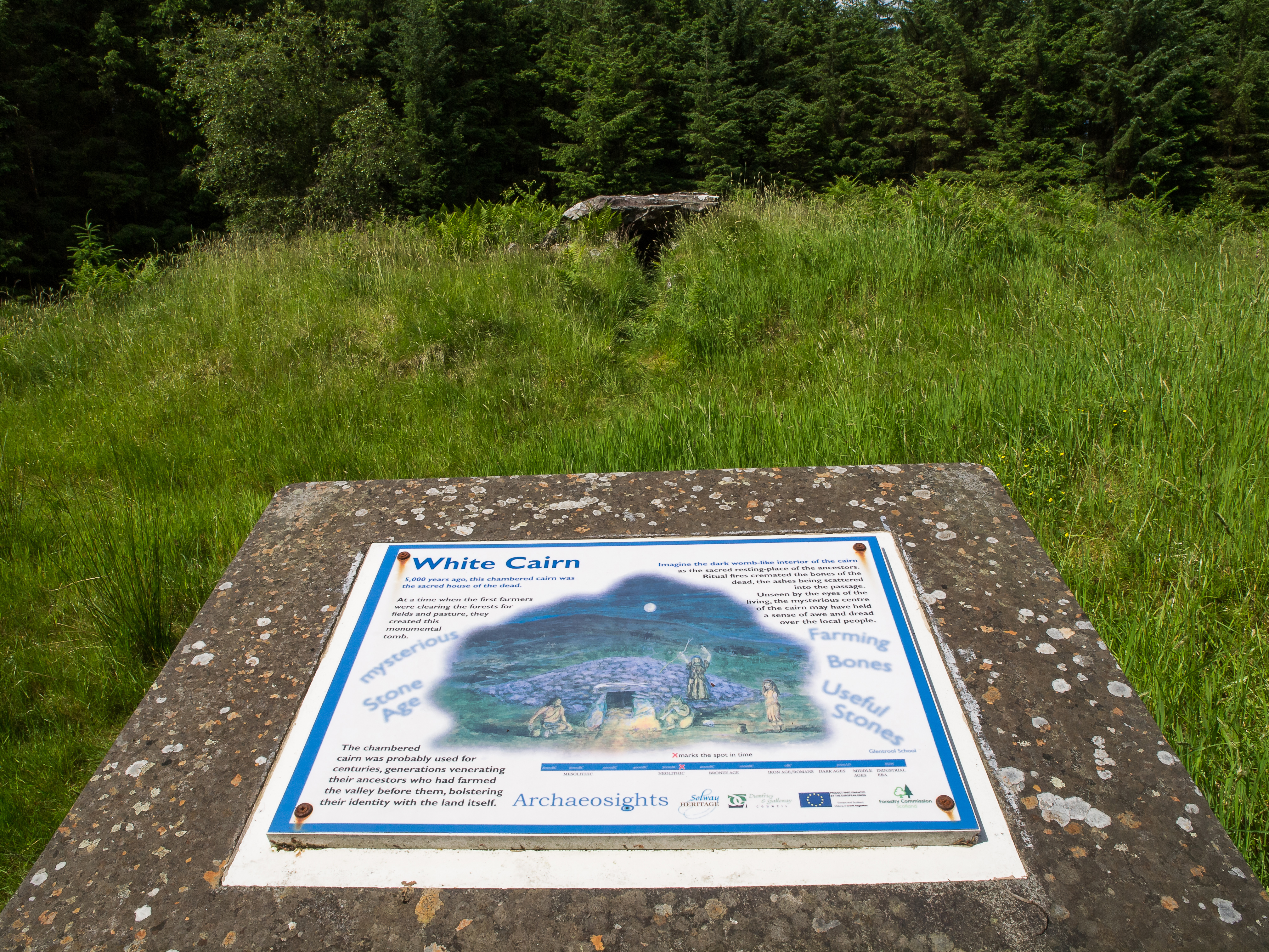
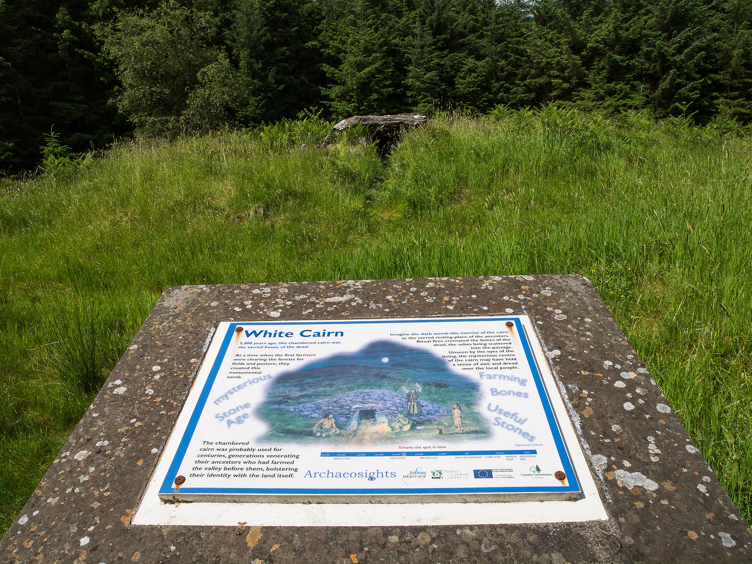
English: White Cairn - interpretation board. This small neolithic chambered cairn was excavated in 1949 and subsequently gave its name to a sub-group of passage graves in which the burial chamber and the passage form a single undifferentiated unit - the Bargrennan group, found only in south-west Scotland. Cremated bones and sherds of neolithic pottery were found in the passage. Further excavations were carried out in 2004 and 2005, and a burial cist and pot, as well as a separate early bronze age burial pot and other artefacts were discovered on either side of the passageway. Late mesolithic flints were also discovered around the edge of the cairn, suggesting human activity at the site over thousands of years of prehistory. |
| Date | |
| Source | From geograph.org.uk |
| Author | David Baird |
| Permission (Reusing this file) |
Creative Commons Attribution Share-alike license 2.0 |
| Attribution (required by the license) | David Baird / White Cairn - interpretation board / |
| Camera location | | View this and other nearby images on: OpenStreetMap |
|---|
Licensing
[edit]

|
This image was taken from the Geograph project collection. See this photograph's page on the Geograph website for the photographer's contact details. The copyright on this image is owned by David Baird and is licensed for reuse under the Creative Commons Attribution-ShareAlike 2.0 license.
|
This file is licensed under the Creative Commons Attribution-Share Alike 2.0 Generic license.
Attribution: David Baird
- You are free:
- to share – to copy, distribute and transmit the work
- to remix – to adapt the work
- Under the following conditions:
- attribution – You must give appropriate credit, provide a link to the license, and indicate if changes were made. You may do so in any reasonable manner, but not in any way that suggests the licensor endorses you or your use.
- share alike – If you remix, transform, or build upon the material, you must distribute your contributions under the same or compatible license as the original.
File history
Click on a date/time to view the file as it appeared at that time.
| Date/Time | Thumbnail | Dimensions | User | Comment | |
|---|---|---|---|---|---|
| current | 19:57, 7 September 2015 | | 4,032 × 3,024 (7.47 MB) | Knochen (talk | contribs) | == {{int:filedesc}} == {{Information |Description={{en|1=White Cairn - interpretation board. This small neolithic chambered cairn was excavated in 1949 and subsequently gave its name to a sub-group of passage graves in which the burial chamber and the... |
You cannot overwrite this file.
File usage on Commons
There are no pages that use this file.
File usage on other wikis
The following other wikis use this file:
- Usage on de.wikipedia.org