File:Wien - Oberes Belvedere, Znaimer Altar.JPG
Jump to navigation
Jump to search
Size of this preview: 800 × 552 pixels. Other resolutions: 320 × 221 pixels | 640 × 441 pixels | 1,024 × 706 pixels | 1,280 × 882 pixels | 2,560 × 1,765 pixels | 5,950 × 4,102 pixels.
Original file (5,950 × 4,102 pixels, file size: 9.42 MB, MIME type: image/jpeg)
Captions
Captions
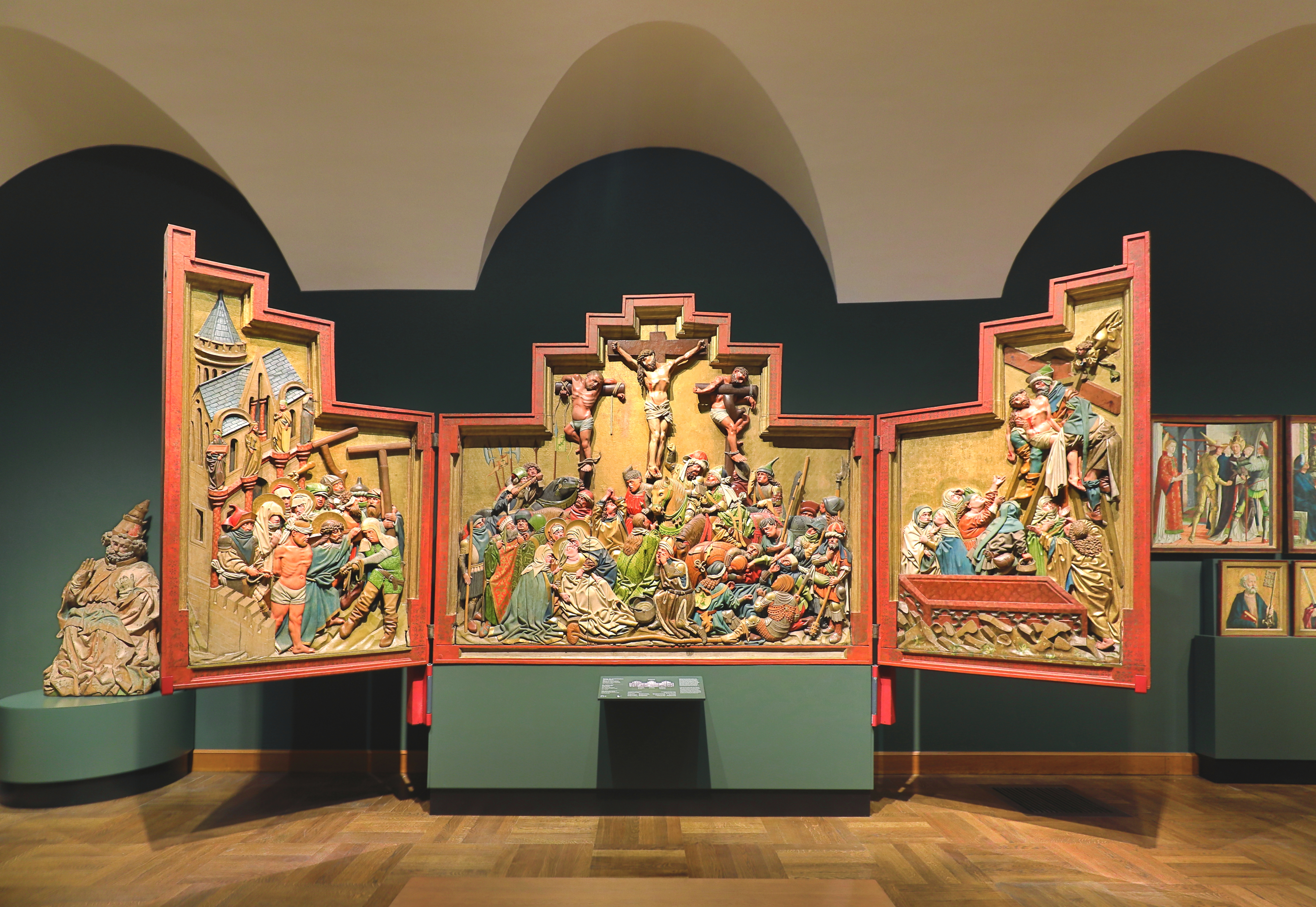
Znaim Altar in the Upper Belvedere in Vienna.
Summary
[edit]
| Description |
Deutsch: Der Znaimer Altar im Oberen Belvedere im 3. Wiener Gemeindebezirk Landstraße.
Der Znaimer Altar wird in die Zeit um 1440–1450 datiert. Er steht in Verbindung zur Wiener Werkstätte des Meisters des Friedrichsaltars, wird aber als Werk aus dem böhmischen Raum behandelt. Sein ursprünglicher Aufstellungsort dürfte die Nikolauskirche in Znaim, heutiges Znojmo, gewesen sein. Später dürfte er dann in die Wenzelskapelle übertragen worden sein, die 1520/21 von der Witwe des Znaimer Martin Bucziczer gestiftet wurde. Die dokumentierte Provenienz des Flügelaltars beginnt mit dem Jahr 1825, indem das Retabel von der Wenzelskapelle in das Schloss Laxenburg überstellt und danach 1870 in die Wiener Hofburgkapelle gebracht wurde. Gefertigt ist der Schrein aus Linden-, Nadel- und Eichenholz und hat eine Abmessung von 254 × 297 cm: [1]. English: Znaim Altar in the Upper Belvedere in Vienna. |
| Date | |
| Source | Own work |
| Author | C.Stadler/Bwag |
| Permission (Reusing this file) |
Deutsch: Hallo, du darfst mein Foto kostenlos nutzen, aber nenne mich bitte als Fotograf, beispielsweise „Foto: C.Stadler/Bwag“ oder © C.Stadler/Bwag; CC-BY-SA-4.0. Auf mehr Angaben bestehe ich nicht - im Gegensatz zu manch anderen, die die Vorgaben der unten angeführten Lizenzierung auf Punkt und Beistrich einfordern. English: Feel free to use my photos, but please mention me as the author like © C.Stadler/Bwag or © C.Stadler/Bwag; CC-BY-SA-4.0 (that's good enough) and if you want send me a message: bwag@gmx.net. |
| Object location | | View this and other nearby images on: OpenStreetMap |
|---|
| Camera location | | View this and other nearby images on: OpenStreetMap |
|---|
Licensing
[edit]
I, the copyright holder of this work, hereby publish it under the following license:
This file is licensed under the Creative Commons Attribution-Share Alike 4.0 International license.
- You are free:
- to share – to copy, distribute and transmit the work
- to remix – to adapt the work
- Under the following conditions:
- attribution – You must give appropriate credit, provide a link to the license, and indicate if changes were made. You may do so in any reasonable manner, but not in any way that suggests the licensor endorses you or your use.
- share alike – If you remix, transform, or build upon the material, you must distribute your contributions under the same or compatible license as the original.
File history
Click on a date/time to view the file as it appeared at that time.
| Date/Time | Thumbnail | Dimensions | User | Comment | |
|---|---|---|---|---|---|
| current | 17:48, 2 April 2023 | | 5,950 × 4,102 (9.42 MB) | Bwag (talk | contribs) | == {{int:filedesc}} == {{Information |Description= {{de|1= Der Znaimer Altar im Oberen Belvedere im 3. Wiener Gemeindebezirk Landstraße.<br/>Der Znaimer Altar wird in die Zeit um 1440–1450 datiert. Er steht in Verbindung zur Wiener Werkstätte des Meisters des Friedrichsaltars, wird aber als Werk aus dem böhmischen Raum behandelt. Sein ursprünglicher Aufstellungsort dürfte die Nikolauskirche in Znaim, heutiges Znojmo, gewesen sein. Später dürfte er dann in die Wenzelskapelle übertragen worden... |
You cannot overwrite this file.
File usage on Commons
There are no pages that use this file.
File usage on other wikis
The following other wikis use this file:
- Usage on de.wikipedia.org