File:Wilderness road en.png
ナビゲーションに移動
検索に移動

このプレビューのサイズ: 800 × 508 ピクセル。 その他の解像度: 320 × 203 ピクセル | 640 × 406 ピクセル | 1,024 × 650 ピクセル | 1,254 × 796 ピクセル。
元のファイル (1,254 × 796 ピクセル、ファイルサイズ: 1.74メガバイト、MIME タイプ: image/png)
キャプション
キャプション
このファイルの内容を1行で記述してください
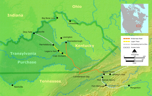
- Description: Course of the Wilderness Road in Kentucky by 2013. Darker green outlines represent the later boundaries of Kentucky, while green shading represents the Transylvania Purchase.
- Source: Own work by Nikater, submitted to the public domain. Background map courtesy of Demis, www.demis.nl.
- Uploader: User:Nikater
- date;14 April 2000
- Other Versions: German Image:Wilderness road_de.png
- License status:
この著作物は、demis.nl/products/web-map-server/examples/を入手元として、著作者により公開されたものであるため、パブリックドメインの状態にあります。この地図は、www.demis.nlからの著作権フリーの画像を基にしているため、コピーや配布、変更が許可されています。ドイツ語版ウィキペディアのメールによる確認と解説もご覧ください。
|
| This work has been released into the public domain by its copyright holder, www.demis.nl. This applies worldwide. 一部の国では、これが法的に可能ではない場合があります。その場合は、次のように宣言します。 www.demis.nlは、あらゆる人に対して、法により必要とされている条件を除き、如何なる条件も課すことなく、あらゆる目的のためにこの著作物を使用する権利を与えます。
|

|
この地図画像は、ベクターイメージである SVG ファイルとして再作成されるべきです。これにはいくつかの利点があります。詳しくはCommons:Media for cleanupを参照してください。この画像の SVG 形式がすでに利用可能である場合は、アップロードしてください。アップロード後、この画像にあるこのテンプレートを{{Vector version available|新しい画像ファイル名.svg}}テンプレートで置き換えてください。
|
ファイルの履歴
過去の版のファイルを表示するには、その版の日時をクリックしてください。
| 日付と時刻 | サムネイル | 寸法 | 利用者 | コメント | |
|---|---|---|---|---|---|
| 現在の版 | 2007年3月23日 (金) 19:16 | | 1,254 × 796 (1.74メガバイト) | Nikater (トーク | 投稿記録) | * Description: Course of the Wilderness Road in Kentucky by 1785 * Source: Own work by Nikater, submitted to the public domain. Background map courtesy of Demis, www.demis.nl. * Uploader: User:Nikater * Date: 23 Mar 2007 * Other Versions: German: Imag |
| 2007年3月21日 (水) 13:24 |  | 1,254 × 796 (1.74メガバイト) | Nikater (トーク | 投稿記録) | * Description: Course of the Wilderness Road in Kentucky by 1785 * Source: Own work by Nikater, submitted to the public domain. Background map courtesy of Demis, www.demis.nl. * Uploader: User:Nikater * Date: 21 Mar 2007 * Other Versions: German: Imag | |
| 2007年3月18日 (日) 17:17 |  | 1,254 × 796 (1.74メガバイト) | Nikater (トーク | 投稿記録) | * Description: Course of the Wilderness Road in Kentucky by 1785 * Source: Own work by Nikater, submitted to the public domain. Background map courtesy of Demis, www.demis.nl. * Uploader: User:Nikater * Date: 18 Mar 2007 * Other Versions: German: Imag | |
| 2007年3月17日 (土) 12:13 |  | 1,255 × 760 (1.63メガバイト) | Nikater (トーク | 投稿記録) | * Description: Course of the Wilderness Road in Kentucky by 1785 * Source: Own work by Nikater, submitted to the public domain. Background map courtesy of Demis, www.demis.nl. * Uploader: User:Nikater * Date: 17 Mar 2007 * Other Versions: German [[Ima |
このファイルは上書きできません。
ファイルの使用状況
以下の 2 ページがこのファイルを使用しています:
グローバルなファイル使用状況
以下に挙げる他のウィキがこの画像を使っています:
- ar.wikipedia.org での使用状況
- ca.wikipedia.org での使用状況
- da.wikipedia.org での使用状況
- de.wikipedia.org での使用状況
- en.wikipedia.org での使用状況
- Henderson, Kentucky
- Elizabethton, Tennessee
- Clarksville, Tennessee
- American frontier
- Transylvania Colony
- Boonesborough, Kentucky
- Wilderness Road
- Cumberland Gap
- Big Bone, Kentucky
- Richard Henderson (jurist)
- Logan Trace
- Sycamore Shoals
- Cherokee–American wars
- User talk:Kevin1776/Archive 2
- John W. Frazer
- User:Brendan.Hunstad/draft on Cumberland Gap
- User:Drdpw/sandbox2
- es.wikipedia.org での使用状況
- fr.wikipedia.org での使用状況
- it.wikipedia.org での使用状況
- ja.wikipedia.org での使用状況
- nl.wikipedia.org での使用状況
- no.wikipedia.org での使用状況
- pl.wikipedia.org での使用状況
- pt.wikipedia.org での使用状況
- ru.wikipedia.org での使用状況
カテゴリ:
- Maps of Kentucky
- Maps of the history of the United States
- Wilderness Road (Kentucky)
- Transylvania Colony
- Sycamore Shoals State Historic Park
- Fort Watauga
- Road transport in the United States in the 1770s
- Maps of the history of Kentucky
- Maps of the history of Tennessee
- Maps showing the 1770s
- Road maps of the United States
- Logan Trace
- Cumberland Gap
- Wilderness Road (Tennessee)