File:World Map 1689.JPG

Fitxer original (4.560 × 3.936 píxels, mida del fitxer: 8,59 Mo, tipus MIME: image/jpeg)
Llegendes
Llegendes
|

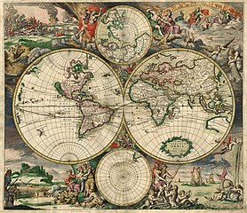
Aquesta imatge va ser escollida imatge del dia el 7 February 2007. La seva descripció va ser la següent: English: An old world map produced in Amsterdam in 1689. Altres idiomes:
Deutsch: Eine 1689 in Amsterdam hergestellte Weltkarte. English: An old world map produced in Amsterdam in 1689. Polski: Mapa świata wyprodukowana w Amsterdamie w roku 1689. Suomi: Hollantilainen maailmankartta vuodelta 1689 Svenska: En gammal världskarta tillverkad i Amsterdam 1689. Winaray: In kahadto nga mapa han kalibutan nga ginhimo ha Amsterdam, 1689. Српски / srpski: Стара карта света направљена у Амстердаму 1689. עברית : מפת עולם משנת 1689 מאמסטרדם |
| This image was selected as a picture of the week on the Persian Wikipedia for the 21è week, 2011. |
Resum[modifica]
| Descripció |
Nederlands: Nova totius terrarum orbis tabula Amstelodami, ex officina G. a Schagen (1682), t'Amsterdam Gedruckt by G. van Schagen, by de Nieuwe Haerlemmer Sluys.
English: World map - Produced in Amsterdam
First edition : 1689. Original size : 48.3 x 56.0 cm. Produced using copper engraving. Extremely rare set of maps, only known in one other example in the Amsterdam University. No copies in American libraries. In original hand color. Français : Carte du monde - Créée à Amsterdam Première édition : 1689. Taille originale : 48,3 x 56,0 cm. Eau forte. |
| Data | This edition 1689 |
| Font | This image is made up of six separate images downloaded from Helmink.com and stitched together. |
| Creador | |
| Permís (Com reutilitzar aquest fitxer) |
Public Domain |
| Georeferencing | If inappropriate please set warp_status = skip to hide. |
| Altres versions | Image:World Map 1689-smaller.jpg (smaller filesize version, easier to download) |
.JPG)
Llicència[modifica]
|
Aquest material està en domini públic als Estats Units i als altres països on el dret d'autor s'estén per 70 anys (o menys) després de la mort de l'autor.
| |
| Aquest fitxer està identificat com a lliure de restriccions conegudes sota la llei de drets d'autor, inclosos els drets veïns. | |
Historial del fitxer
Cliqueu una data/hora per veure el fitxer tal com era aleshores.
| Data/hora | Miniatura | Dimensions | Usuari/a | Comentari | |
|---|---|---|---|---|---|
| actual | 00:59, 4 set 2013 | | 4.560 × 3.936 (8,59 Mo) | Crisco 1492 (discussió | contribucions) | Reverted to version as of 12:34, 16 October 2010 |
| 00:47, 4 set 2013 |  | 4.560 × 3.936 (19,56 Mo) | Crisco 1492 (discussió | contribucions) | Reverted to version as of 01:01, 30 November 2006 Per Commons:Overwriting existing files, do not overwrite featured images | |
| 12:34, 16 oct 2010 |  | 4.560 × 3.936 (8,59 Mo) | Brandmeister~commonswiki (discussió | contribucions) | slight adjustment | |
| 01:01, 30 nov 2006 |  | 4.560 × 3.936 (19,56 Mo) | Tarawneh (discussió | contribucions) | == Summary == {{Information |Description= World map - Produced in Amsterdam<br> FIRST edition : 1689 <br> Original size : 48.3 x 56.0 cm <br> Produced using copper engraving |Source= scanned copy |Date= This edition 1689 |Author= van Schagen |Permission |
No podeu sobreescriure aquest fitxer.
Ús del fitxer
Hi ha més de 100 pàgines que utilitzen aquest fitxer. La següent llista només mostra les primeres 100 d'aquestes pàgines que utilitzen aquest fitxer. Podeu consultar la llista completa.
- Maps of the world
- User:Dschwen/FP2006
- User:Mav
- User:Pvasiliadis/PVasiliadisMadeBy
- User talk:Tarawneh/Archive1
- Commons:Featured picture candidates/Image:World Map 1689.JPG
- Commons:Featured picture candidates/Log/December2006
- Commons:Featured pictures/Non-photographic media/Maps
- Commons:Featured pictures/chronological/2006-B
- Commons:Picture of the Year/2006/gallery
- Commons:Picture of the Year/2006/gallery0
- Commons:Picture of the Year/2006/gallery large
- Commons:Potd/2007-02 (als)
- Commons:Potd/2007-02 (an)
- Commons:Potd/2007-02 (ar)
- Commons:Potd/2007-02 (ast)
- Commons:Potd/2007-02 (be)
- Commons:Potd/2007-02 (bg)
- Commons:Potd/2007-02 (br)
- Commons:Potd/2007-02 (ca)
- Commons:Potd/2007-02 (cs)
- Commons:Potd/2007-02 (cy)
- Commons:Potd/2007-02 (da)
- Commons:Potd/2007-02 (de)
- Commons:Potd/2007-02 (el)
- Commons:Potd/2007-02 (en)
- Commons:Potd/2007-02 (eo)
- Commons:Potd/2007-02 (es)
- Commons:Potd/2007-02 (fa)
- Commons:Potd/2007-02 (fi)
- Commons:Potd/2007-02 (fr)
- Commons:Potd/2007-02 (ga)
- Commons:Potd/2007-02 (gl)
- Commons:Potd/2007-02 (gu)
- Commons:Potd/2007-02 (he)
- Commons:Potd/2007-02 (hu)
- Commons:Potd/2007-02 (it)
- Commons:Potd/2007-02 (ja)
- Commons:Potd/2007-02 (ko)
- Commons:Potd/2007-02 (la)
- Commons:Potd/2007-02 (lb)
- Commons:Potd/2007-02 (lt)
- Commons:Potd/2007-02 (nan)
- Commons:Potd/2007-02 (nb)
- Commons:Potd/2007-02 (nl)
- Commons:Potd/2007-02 (nn)
- Commons:Potd/2007-02 (pl)
- Commons:Potd/2007-02 (pt)
- Commons:Potd/2007-02 (ro)
- Commons:Potd/2007-02 (ru)
- Commons:Potd/2007-02 (sk)
- Commons:Potd/2007-02 (sl)
- Commons:Potd/2007-02 (sq)
- Commons:Potd/2007-02 (sr)
- Commons:Potd/2007-02 (sv)
- Commons:Potd/2007-02 (th)
- Commons:Potd/2007-02 (tr)
- Commons:Potd/2007-02 (vi)
- Commons:Potd/2007-02 (zh-hans)
- Commons:Potd/2007-02 (zh-hant)
- Commons talk:Featured picture candidates/Archive candidate list
- File:David Selinitziotis H Porni.JPG
- File:David Selinitziotis H Porni O Filargyros.JPG
- File:David Selinitziotis O Pornos H Magissa.JPG
- File:Ekkatharistiki Dilosi EllinoTourkikis Antallagis Plythismon sel1 19271216a.jpg
- File:Emperor Hadrianus Crete 2nd century Istanbul Museum.jpg
- File:Head of Sappho Smyrna Istanbul Museum Hellenistic period.JPG
- File:JEHOVAH at RomanCatholic Church Martinskirche Olten.JPG
- File:Kastoria1 200704.JPG
- File:Limni Pamvotida Ioannina 20061220.JPG
- File:Nymfaio1.JPG
- File:Ottoman Baths at Traianoupoli Greece.JPG
- File:Parga2006a.JPG
- File:Paris View from the Eiffel Tower third floor Seine downstream night.jpg
- File:Roman Baths Hana at Traianoupoli Greece.JPG
- File:StatueOfMarsyas 3d cent BCE Istanbul Museum.JPG
- File:Tetragrammaton Paris StMichele.JPG
- File:Tetragrammaton at RomanCatholic Church Saint-Germain Paris France.JPG
- File:VandiDespoina 20070324.JPG
- Template:Potd/2007-02
- Template:Potd/2007-02-07
- Template:Potd/2007-02-07 (cs)
- Template:Potd/2007-02-07 (de)
- Template:Potd/2007-02-07 (en)
- Template:Potd/2007-02-07 (eo)
- Template:Potd/2007-02-07 (es)
- Template:Potd/2007-02-07 (fi)
- Template:Potd/2007-02-07 (fr)
- Template:Potd/2007-02-07 (he)
- Template:Potd/2007-02-07 (hu)
- Template:Potd/2007-02-07 (it)
- Template:Potd/2007-02-07 (ja)
- Template:Potd/2007-02-07 (pl)
- Template:Potd/2007-02-07 (pt)
- Template:Potd/2007-02-07 (ro)
- Template:Potd/2007-02-07 (ru)
- Template:Potd/2007-02-07 (sr)
- Template:Potd/2007-02-07 (sv)
- Template:Potd/2007-02-07 (tr)
- Template:Potd/2007-02-07 (war)
Visualitza més enllaços que porten al fitxer.
Ús global del fitxer
Utilització d'aquest fitxer en altres wikis:
- Utilització a af.wikipedia.org
- Utilització a ar.wikipedia.org
- Utilització a ba.wikipedia.org
- Utilització a bg.wikipedia.org
- Utilització a bg.wikiquote.org
- Utilització a bjn.wikipedia.org
- Utilització a bn.wikipedia.org
- Utilització a bs.wikipedia.org
- Utilització a ca.wikipedia.org
- Utilització a ce.wikipedia.org
- Utilització a crh.wikipedia.org
- Utilització a cs.wikipedia.org
- Utilització a cv.wikipedia.org
- Utilització a de.wikipedia.org
- Utilització a el.wikipedia.org
Vegeu més usos globals d'aquest fitxer.