File talk:DemoBIH2006a.png
serbs position[編集]
change serbs position to the left — Preceding unsigned comment was added by 169.229.125.17 (talk) 06:25, August 21, 2008 (UTC)
source data?[編集]
I would like to learn about the original data source for this map, and whether it is available on the web somewhere. Could the author please write this here or contact me? --Paxbldr (talk) 22:34, 10 January 2009 (UTC)
- I tried to found it, but it is not avaible any more. Map was named DemoBiH2006 (I forgot the format, probably png) and it was made by Varjačić Vladimir under GFDL licence. Different from it were borders of Žepče municipality [1], percentage of Bosniaks in Uskoplje and Fojnica (Croats are a little bit more than 1/3 there) etc... which can be seen in list of the changes --Čeha (talk) 20:19, 11 January 2009 (UTC)
Hi Čeha, thanks for responding. I see another map here http://en.wikipedia.org/wiki/File:B_2005.GIF which apparently you made for 2005 from data you got from the Federation of BiH Statistical Institute. Is that also the data you can no longer find for this 2006 map? Any idea why it is no longer there? Perhaps it was deemed unreliable? Or just too politically sensitive? I have seen a reference to UNHCR 1996 "census" data here http://en.wikipedia.org/wiki/History_of_the_demographics_of_Bosnia_and_Herzegovina - do you happen to know where that can be found, or who wrote that portion of the page? I see you were involved with much of that page. I cannot find any reference to it on UNHCR's website. --Paxbldr (talk) 00:46, 12 January 2009 (UTC)
Realy don't know. [2] was made from data from statistical institute, I did not even knew, that it is not on it's pages any more...
This map (DemoBIH2006a.png) is from another source (somebody else made it) and I just changed some things which were wrong. The original was deleted (and I don't know because of what).
As for UNHCR 1996 census, I've heard that it was taken (and not recognised as official) but also don't know where it can be found.
Sorry. --Čeha (talk) 21:25, 18 January 2009 (UTC)
File:DemoBIH2006a.png[編集]
Source???Tonka (talk) 19:58, 23 March 2010 (UTC)
![]() 存続 Amada44 (talk) 07:18, 31 March 2010 (UTC)
存続 Amada44 (talk) 07:18, 31 March 2010 (UTC)
 コメント I'd translate this file from File:DemoBIH2006a.PNG, in english Wikipedia, but now this image was deleted, I don't know because. --Goldorak (talk) 11:55, 31 March 2010 (UTC)
It seems it has never existed(if it had, there would be a message with the reason for deletion). --GaAs11671 15:39, 31 March 2010 (UTC)- OK, this is DemoBIH2006.PNG (without the "a"): 21:38, 29 December 2006 Electionworld (talk | contribs) deleted "File:DemoBIH2006.PNG" (Moved to commons). The image on commons has also be deleted: 5 juin 2008 à 19:39 Siebrand (discuter | contributions) a supprimé « File:DemoBIH2006.PNG » (Dupe of Image:DemoBIH2006a.png). An admin could bring back the original description.
 存続 --GaAs11671 16:15, 31 March 2010 (UTC)
I'm an admin on en-wiki. The deleted page said:
- == Summary ==
- Taken from Serbian Wikipedia, the Republika Srpska article. It was created by a Serbian user based on various statistical data.
- There are some inaccuracies in the map (borders of Brčko district, etc.)
- == Licensing ==
- {{GFDL-no-disclaimers}}:<nowiki> :<nowiki>[[Category:Maps of the Federation of Bosnia and Herzegovina]]:<nowiki> :<nowiki>[[Category:Maps of Bosnia and Herzegovina]]
So source wasn't quite clear on en-wiki, either, but might be on the Serbian Wikipedia. - Jmabel ! talk 17:27, 31 March 2010 (UTC)
- Thanks. It gives 5 janvier 2007 à 00:11 Саша Стефановић a supprimé « Слика:DemoBIH2006.PNG » (Има на остави под истим именом) (automatic translation: It has to leave under the same name). We should not delete files before ensuring the derivatives are correctly described. :( --GaAs11671 13:14, 1 April 2010 (UTC)
- LoL, that automatic translation isn't ok. That is template for "File exist on commons under same name". This is file description on sr: wiki before was deleted because being duplicate. Licence was {{PD}} and author is "Varjacic Vladimir"
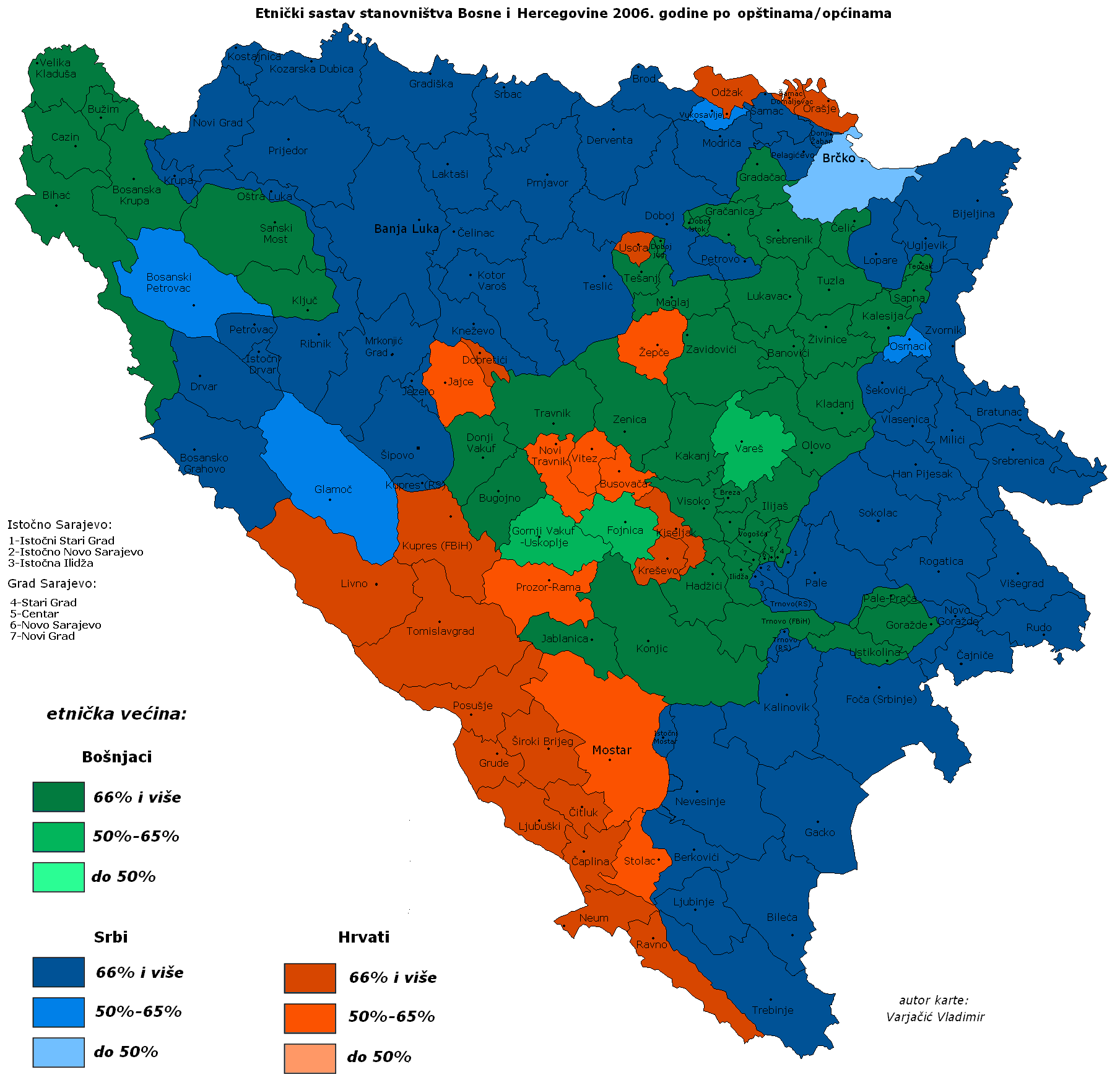
Autor varjačić Vladimir, podaci po proceni federelnog zavoda za statistiku, Distikt Brčko je uzet po dejtonskoj podeli iako je jedna celina da bi se video sastav stanovništva po sastavnim delovima. podaci su po aktuelnoj teritorijalnoj organizaciji 2006. godine.
{{PD}}
I deleted it just because being duplicate on sr: wiki. Саша Стефановић (talk) 19:02, 1 April 2010 (UTC)
- Duplicates of duplicates all deleted, and at the end just stays the duplicate duplicate duplicate duplicate whith no credible license info, and everything is deleted. :( --GaAs11671 21:08, 1 April 2010 (UTC)
problems[編集]
licensing problems[編集]
- The licensing is incorrect. I am working on fixing it. The original image must be restored, and the standard licenses that varjarcic always uses has to be returned. A number of the guys maps have wrong licensing. (LAz17 (talk) 04:36, 5 June 2011 (UTC)).
original image[編集]
So I am looking for the original image, in order to return it.
- Here is the original [3] Hopefully I can find the original size. (LAz17 (talk) 05:03, 5 June 2011 (UTC)).
- Bigger size. [4] Getting closer. (LAz17 (talk) 05:05, 5 June 2011 (UTC)).
- Even closer. [5] (LAz17 (talk) 05:13, 5 June 2011 (UTC)).
- Well I give up for now. Perhaps I'll be able to find the correct image later, or perhaps Varjarcic could upload the correct one. I think I'll contact him. (LAz17 (talk) 05:30, 5 June 2011 (UTC)).
![[3]](http://www.websters-online-dictionary.org/images/wiki/wikipedia/commons/thumb/9/98/DemoBIH2006.PNG/120px-DemoBIH2006.PNG)
![[4]](http://www.cs.mcgill.ca/~rwest/wikispeedia/wpcd/images/20/2009.png)
![[5]](http://img262.imageshack.us/img262/6518/demobih2006zy4.jpg)
Solution[編集]
Changes to this file cause controversy, more than enough to satisfy the requirements of COMMONS:OVERWRITE, and so changes should not be made to the first version of this version of the image.
- This is probably not the original version of this map image. The 'original version' most likely doesn't have an 'a' suffix on the filename, if that file is ever found, please upload it using the filename DemoBIH2006.
- I have reverted to the first version of this 'DemoBIH2006a' version. Please upload changes to new filenames. As hint to make it easy, I suggest just upload using the upload wizard, click 'own work' and save. Then open this file's filepage for editing, select everything (Ctrl-A) copy everything (Ctrl-C) and paste everything (Ctrl-V) to the new upload's filepage, then edit what you like. Takes only a short time this way to make all your new versions with a minimum of effort.
- For a CURRENT version of the image, for the many articles, rather than a historic 2006 image which this appears to be, may I suggest uploading to the filename such as 'Current demographics of Bosnia and Herzegovina' or if that is too long, maybe something like 'DemoBosHerzCurrent' without the 2006 in the name, and keep that updated with all the latest changes.
- Think of adding a suffix when sources differ, like if some author called jake says a border today is in one place and an author called Ike says the border today is somewhere else, then use 'DemoBosHerzCurrentIke' and 'DemoBosHerzCurrentJake'
- All discussions over which file is used in an article belong on the local wiki, not on commons.
I hope this helps, if you need further help just ask here or on my talkpage, I've added this file to my watchlist. Penyulap ☏ 21:35, 11 July 2013 (UTC)
- Almost forgot, if anyone has any difficulty to create their own version of this file, then please make a request at Commons:Graphic Lab/Map workshop and if you can describe it or point to an image on the internet, we can make it for you. Penyulap ☏ 21:42, 11 July 2013 (UTC)
- I would agree with this solution (if necessary), but the version I uploaded yesterday has more precise municipal grid. Also, at that time Brčko municipality wasn't divided in three seperate municipalities... Everything else is the same as version by IoannesII (17:26, 2. prosinca 2012.) (before lilic controversial changes).If there is need for consensus, I can upload this as seperate map. --Čeha (talk) 14:31, 12 July 2013 (UTC)
- How about uploading it to DemoBosHerzCurrent.png ? If it is the most up-to-date version, we can place it into all the articles on the local wikis. Penyulap ☏ 17:24, 12 July 2013 (UTC)
- Map changed from that time, but there wasn't a census so those changes are not for certain... I could upload it as a DemoBIH2006.png or DemoBiH2006MunPrecise.png or something like that, but it is basically the same map as this one. Maps of municipal borders are a little bit more precise... --Čeha (talk) 18:11, 12 July 2013 (UTC)
- I think the second option is best, as the first option would be best if we can ever find the very first map ever of this kind uploaded, that would probably need assistance from admins on the local wikis. DemoBiH2006MunPrecise.png or similar would be fine. Penyulap ☏ 18:18, 12 July 2013 (UTC)
- Done http://commons.wikimedia.org/wiki/File:DemoBiH2006MunPrecise.png.png . I just hope that this map will stay original, and that user Lilic will not meddle with it. --Čeha (talk) 19:34, 12 July 2013 (UTC)
- Excellent. For changes, just use the file talkpage, if everyone doesn't agree with new changes to the file, then changes would be considered controversial, COMMONS:OVERWRITE would apply, and the change may be reverted. Anyone can upload their own versions to new filenames. Penyulap ☏ 19:51, 12 July 2013 (UTC)
- Ok, thnx:) --Čeha (talk) 20:16, 12 July 2013 (UTC)
- You're welcome. I do hope everyone finds the solution acceptable. Penyulap ☏ 20:25, 12 July 2013 (UTC)
- Ok, thnx:) --Čeha (talk) 20:16, 12 July 2013 (UTC)
- Excellent. For changes, just use the file talkpage, if everyone doesn't agree with new changes to the file, then changes would be considered controversial, COMMONS:OVERWRITE would apply, and the change may be reverted. Anyone can upload their own versions to new filenames. Penyulap ☏ 19:51, 12 July 2013 (UTC)
- Done http://commons.wikimedia.org/wiki/File:DemoBiH2006MunPrecise.png.png . I just hope that this map will stay original, and that user Lilic will not meddle with it. --Čeha (talk) 19:34, 12 July 2013 (UTC)
- I think the second option is best, as the first option would be best if we can ever find the very first map ever of this kind uploaded, that would probably need assistance from admins on the local wikis. DemoBiH2006MunPrecise.png or similar would be fine. Penyulap ☏ 18:18, 12 July 2013 (UTC)
- Map changed from that time, but there wasn't a census so those changes are not for certain... I could upload it as a DemoBIH2006.png or DemoBiH2006MunPrecise.png or something like that, but it is basically the same map as this one. Maps of municipal borders are a little bit more precise... --Čeha (talk) 18:11, 12 July 2013 (UTC)
- How about uploading it to DemoBosHerzCurrent.png ? If it is the most up-to-date version, we can place it into all the articles on the local wikis. Penyulap ☏ 17:24, 12 July 2013 (UTC)
- Well I think that this is not a good solution. One reason why is because there is no source, and the second problem is that Ceha immediately proceeded to put that image on almost every page that he could. He is an experienced edit warrior, and alas the problem is that there is no real good source for this image to be on so many pages. Lastly, varjarcic should be making a new image, and finally, I am out of town so I really don't have much time to write now! (Lilic (talk) 18:44, 13 July 2013 (UTC)).
- understood. The way to finalise the source issue once and for all would be a DR. I would expect it may fall short of COMMONS:TOO as it is a simple looking map. The local wikis are the place to address sources, while commons demands sources for the image, it has no policy relating to the sources of the content itself. For example, islands in the south china sea are fought over by many nations. Multiple maps would show them as belonging to conflicting countries, and your position may depend upon where you are from. Commons doesn't seek to rule who owns those islands, it only wants to make sure that the artists who draw the maps for those islands (regardless of how they are drawn) give permission for their maps to be stored here. Penyulap ☏ 18:56, 13 July 2013 (UTC)
- Could you explain me what is the problem with the precised map? Everything is sourced, and all of the licenses are good... What is DR? --Čeha (talk) 22:45, 13 July 2013 (UTC)
- I do not know if there is any problem with the map(s). My assistance is limited to finding solutions that everyone can live with. Rather than argue which map is the correct map, we have different maps. Beyond that, if one person wishes to delete someone else's map, then DR is the place, it is Deletion Requests. At DR, a file is examined to see if it is worth keeping on commons, if it may serve some use. DR is better than the frustration two editors can have trying to explain things to each other, because at DR, there are additional opinions from random strangers :) so you have a fresh perspective. They can also tell you about the rules and guidelines. Penyulap ☏ 00:19, 14 July 2013 (UTC)
- Great, thanks :) --Čeha (talk) 12:54, 14 July 2013 (UTC)
- I do not know if there is any problem with the map(s). My assistance is limited to finding solutions that everyone can live with. Rather than argue which map is the correct map, we have different maps. Beyond that, if one person wishes to delete someone else's map, then DR is the place, it is Deletion Requests. At DR, a file is examined to see if it is worth keeping on commons, if it may serve some use. DR is better than the frustration two editors can have trying to explain things to each other, because at DR, there are additional opinions from random strangers :) so you have a fresh perspective. They can also tell you about the rules and guidelines. Penyulap ☏ 00:19, 14 July 2013 (UTC)
- Penyulap, Ceha, since he uploaded his new version, has gone about trying to insert that file into many wikipedias. It's a controversial image, and by inserting it all over he in effect is doing his best to try to maintain it. Now, the solution is not edit waring... what do you suggest the solution to be? (Lilic (talk) 16:33, 16 July 2013 (UTC)).
As was agreed. As for controversion of image it is best for you to try to start DR request. After that I'm preety sure there will be no more talk about any kind of "controversion".--Čeha (talk) 06:30, 19 July 2013 (UTC)
- I would say that there is no consensus. Proof of that is your eagerness to replace the image - and I could in theory do the same thing but that does not solve the problem. You do not want to solve the problem, you just want your flawed image to be put up. (Lilic (talk) 21:52, 21 July 2013 (UTC)).
- You have quietly gone about removing this map from almost all the wikipedia pages on which it was. How is that an honest move that is going to resolve this matter? (Lilic (talk) 21:55, 21 July 2013 (UTC)).
- As User Lilic deleted https://commons.wikimedia.org/w/index.php?title=File:DemoBiH2006MunPrecise.png&action=edit&redlink=1 and that he claimes there is no consensus, I returned correct map under this name --Čeha (talk) 22:44, 6 January 2014 (UTC)
- You are not allowed to simply change people's maps without consensus. The current map is not even the original map of the author, it has been changed thanks to your tampering of it. That's terrible. Leave people's works alone. (Lilic (talk) 14:22, 17 April 2014 (UTC)).
- Once again, this version is more correct than the original. And the original map is under the licence in wich it is possible to do so. I would ask you to stand by wikipedia and wikimedia commons rules... --Čeha (トーク) 10:49, 17 May 2014 (UTC)
- You are not allowed to simply change people's maps without consensus. The current map is not even the original map of the author, it has been changed thanks to your tampering of it. That's terrible. Leave people's works alone. (Lilic (talk) 14:22, 17 April 2014 (UTC)).
- As User Lilic deleted https://commons.wikimedia.org/w/index.php?title=File:DemoBiH2006MunPrecise.png&action=edit&redlink=1 and that he claimes there is no consensus, I returned correct map under this name --Čeha (talk) 22:44, 6 January 2014 (UTC)
- The author NEVER uploads under such a license which you claim. Things got lost/changed as you have numerous times uploaded and reuploaded various versions of his map. It is questionable as to weather or not the original can still be retrieved - this is your fault because you kept changing the file even before it was on Wikimedia. I will email Varjacic again to ask him for his original, if he can find it or recreate it. Of course, it shows something very different from what you want to impose. (Lilic (トーク) 05:11, 6 August 2014 (UTC)).
 | このファイルは以前削除が依頼されましたが存続となりました。 そのときの削除に関する議論がこちらにありますので、再度削除依頼をしようとする場合は考慮にお入れください。 |
- Have you done anything of that which you claimed you'll do? I'm not changing anything, you are the one with a crusade against legal maps... --Čeha (トーク) 09:38, 9 October 2014 (UTC)
Edit war[編集]
Please stop. You said there is a problem with the municipal grid, I've given new grid map. What's the problem? --Čeha (トーク) 17:02, 23 May 2015 (UTC)
Mislim, koji ti je? U dozvoli piše sljedeće; remiksirati – prerađivati djelo, Pod sljedećim uvjetima: imenovanje autora i dijeli pod istim uvjetima. Bunio si se kontra toga, iako je dozvola jasna, a ispravio sam greške, pa sam stavio drugu kartu, da se ne koristi od Varjačića (iako je čovjek dao dozvolu po ovoj licenci). Kaj te smeta ? Karte ti ne pašu ili ? Daj malo profesionalnosti. --Čeha (トーク) 17:06, 23 May 2015 (UTC)
- You have no right to replace this image with that other image. This image may have some issues - but to replace it with a worse image is not the solution.
- Furthermore, I clearly suggested that all such images be removed, that is, that we wait until the next census results come out. You did not want to do that, and instead replace this map by a horridly colored map, which does not reflect the year which this map reflects. If you do not want to delete this map, well okay, but, it is not fair to alter this map. (Lilic (トーク) 02:39, 17 June 2015 (UTC)).
- I have uploaded many maps. I would not be pleased if someone started replacing my maps like you are doing here. That simply is not allowed. Hence, if you remove it, I bring it map. The map is not up for altering, unless if Varjacic wants to do so. I have contacted him in the past but he did not seem interested in working on the map more. I mean come on, we should respect the author. (Lilic (トーク) 02:41, 17 June 2015 (UTC)).
This map DemoBIH2006a.png is from its begining diferent that original Varjačić map (DemoBIH2006.png). You can see that here https://upload.wikimedia.org/wikipedia/commons/archive/2/22/20080626122344!DemoBIH2006a.png . Because of your views, any Varjačić material (although alowed by licenses) was removed. What's the problem? This is not your nor Varjačić map. If you wish, you re welcome onto uploading another map with another name. As you said you would not edit other people's map, please stay true to your words.. --Čeha (トーク) 00:26, 2 July 2015 (UTC)
- On the Serbian wiki they brought back the original file which was initially used. Hence, the file is indeed the correct original file. The "a" file should never have been uploaded in the first place. That is why I suggested that the file gets deleted, some time ago. Furthermore, Varjacic is my friend and he confirmed that that image is indeed the original image. Lastly, Varjacic never uploads under a free to share license, so I suggest that you stop removing someone else's image. (Lilic (トーク) 19:29, 5 July 2015 (UTC)).
- let's go again; what does this map https://upload.wikimedia.org/wikipedia/commons/archive/2/22/20150705192722!DemoBIH2006a.png has to do with you or varjačić? These are commons, not serbian wiki. Plese stop reverting other people map. --Čeha (トーク) 01:55, 7 July 2015 (UTC)
- Basicly, what's your problem? You do not like the data which map shows or what? https://upload.wikimedia.org/wikipedia/commons/archive/2/22/20150705192722!DemoBIH2006a.png is my map, there is nothing in it which would connect you or Varjačić to it. Why are you behaving so unprofessional? "A" file was put here under free to share licence, you warned that some data is not under that licence, and that data (or anything to do with Varyachich) was removed. So why are you reverting my map? On wich grounds? Once again, this map has nothing to do with you or anybody else. --Čeha (トーク) 02:20, 7 July 2015 (UTC)
- It is your map sure, but, it does not reflect the year that the original image is about, and furthermore, this map whose file is in question is Varjarcic's map. You can't simply put an image of a cow, a house, another map, or anything else over another image and expect that nobody would have a problem with that. Go to my page - do you think I would like it if you put anything over any of my images? I don't think so. Likewise you should understand that it is not fair simply post your stuff over other people's stuff like this. If you want to put your map up, you can do so without putting it over someone else's file. Now, of course, I would like to see both files deleted, but, you opposed this map to be deleted, as did others I think, and so this map stays. (Lilic (トーク) 18:17, 7 July 2015 (UTC)).
- Again? Bolded text is false. It does. And there is the problem. You do not like the data, and that's all.
- If we had a picture of a horse in a miny skirt and you warned about copyright (withouth proof, but it doesn't matter), so we change that picture into another one wich does not has any alleged problems, what would you say to people who would mind it?
- Ili na hrvatskom, provociraš. I petljaš se po karti s kojom nemaš veze. Tražit ću zabranu tvog petljanja po ovome, jer si stvarno prešao mjeru! --Čeha (トーク) 19:49, 7 July 2015 (UTC)
- As I told you before, you may not overwrite another person's map in such a manner. There is nothing controversial there.
- Regarding a horse and miniskirt - it would depend on what the licensing is. If it is the original uploader then perhaps it would be okay to over-write it. But, otherwise other people should not over-write other people's images in my opinion, especially not if the licensing does not allow it, as is the case here. I believe these are also official wikimedia rules. (Lilic (トーク) 18:38, 8 July 2015 (UTC)).
- @Lilic: People should not be overwriting images with ones that are substantially different (see COM:OVERWRITE) or continuing to do so in there change has been reverted (see COM:UPLOADWAR), but it is not a copyright issue. All Commons-compatible licenses allow for the creation of derivative works, so the overwriting of an image like this with a derivative made to correct minor errors (such as if boundaries are incorrect) is not a copyright violation, as long as the attribution is maintained. The only apparent copyright problem here is that the attribution 'on the file page' was messed up as this was transferred around, but since it (and I'm referring to the blue map) was attributed in the file itself it's not really a copyright violation unless it was never actually placed under a compatible license. Revent (トーク) 22:47, 8 July 2015 (UTC)
- @Lilic It is not other person map. This map https://upload.wikimedia.org/wikipedia/commons/archive/2/22/20080626122344!DemoBIH2006a.png shows the same data as this map https://upload.wikimedia.org/wikipedia/commons/2/22/DemoBIH2006a.png !
This map, which are https://upload.wikimedia.org/wikipedia/commons/archive/2/22/20150707194159!DemoBIH2006a.png you trying to upload shows different data!
- @Revent There was no copywrite issues, but I tried to compromise with Lilic. I am realy seek of edit war. So I changed the colors and municipal grid. But the guy is like a broken record. He tried to delete the map (his suggestions were revoked), and he is trying to delete it still. He doesn't like the data and that's all.... --Čeha (トーク) 15:29, 9 July 2015 (UTC)
- @Ceha: I agree, there appear to have been no 'unauthorized use of copyrighted material' issues, and there appear to have been misunderstandings about that, based on the fact that an 'unattributed' use of CC or GFDL material is technically a copyright violation. I suspect, though it would be incredibly hard to sort out at this point (edit and upload wars are a massive pain in the ass), that the perceived copyright issue was a combination of misunderstandings and a loss of proper attribution through all the changes. I strongly suggest we all agree to consider the prior arguments to be based on misunderstandings, either of people's opinions or of the exact terms of the licenses, and simply move forward. The question of which version of a map (specifically, the data base reflected by the map, as opposed to specific versions with obvious fixes like adding a name) should be used is not an issue for Commons, but for the local wikis that use it. What is disruptive 'here' is overwriting a file with one that is substantially different, as it has the effect of 'stealthily' changing what image is used on local wikis without notifying them. Revent (トーク) 18:20, 9 July 2015 (UTC)
- To state my position more explicitly... I am just trying to step in here as a 'Commons' admin, to be a impartial third party as regard the actual issues 'here'. I do not know what is 'correct', either in regards to the map data or the cartographical issues, and could not do my 'job' if I had an opinion. I'm just trying to ignore the prior 'dramatic' aspects of this, and sort things out in a way that respects Commons policies and allows the controversial 'content' aspects of this to be dealt with on the local wikis where they belong, without Commons 'mandating' what is correct. We do not say 'this is right' or 'that is right', unless there is a consensus that something was a clear error... we say 'these are alternate versions, that there was a dispute about'. Even an incorrect map can be useful under our scope, if for nothing else than documenting the dispute, as long as it factually respects the indicated source. Here, where no independent source was ever cited, we are reduced to letting reusers (including those on other wikis) choose how they wish to handle the debate, and only allowing changes to a particular version that were clearly not controversial with regard to that particular version. Revent (トーク) 18:41, 9 July 2015 (UTC)
- @Ceha: I agree, there appear to have been no 'unauthorized use of copyrighted material' issues, and there appear to have been misunderstandings about that, based on the fact that an 'unattributed' use of CC or GFDL material is technically a copyright violation. I suspect, though it would be incredibly hard to sort out at this point (edit and upload wars are a massive pain in the ass), that the perceived copyright issue was a combination of misunderstandings and a loss of proper attribution through all the changes. I strongly suggest we all agree to consider the prior arguments to be based on misunderstandings, either of people's opinions or of the exact terms of the licenses, and simply move forward. The question of which version of a map (specifically, the data base reflected by the map, as opposed to specific versions with obvious fixes like adding a name) should be used is not an issue for Commons, but for the local wikis that use it. What is disruptive 'here' is overwriting a file with one that is substantially different, as it has the effect of 'stealthily' changing what image is used on local wikis without notifying them. Revent (トーク) 18:20, 9 July 2015 (UTC)
- @Revent There was no copywrite issues, but I tried to compromise with Lilic. I am realy seek of edit war. So I changed the colors and municipal grid. But the guy is like a broken record. He tried to delete the map (his suggestions were revoked), and he is trying to delete it still. He doesn't like the data and that's all.... --Čeha (トーク) 15:29, 9 July 2015 (UTC)
request for comment[編集]
I have submitted a request for comment here, https://commons.wikimedia.org/wiki/Commons_talk:Centralized_discussion#RFC_on_edit_war , and hope that some outside people can give some comments or suggests as to how to resolve this issue. My suggestion is to kill the current file page - for ceha to have his image uploaded on a separate place, and to have the original varjacic map transferred properly from the serbian wikipedia. I don't now if that's too much to ask for, but, that's what i would propose. (Lilic (トーク) 20:07, 8 July 2015 (UTC)).
- I think that it fairly unquestionable that the current version (the brown one) is distinctly different, and thus a violation of COM:OVERWRITE... I think should be split from this file, to a new name, and I am willing to do so if there is a consensus. I think it really needs to be done, partly because the current status of the file page (attributing this to Vladimir Varjacic, sr:User:Варја) does not match that of the actual file (which seems to be the work of Ceha). If everyone will agree to this, first, then I think we can get down to a more meaningful discussion of fixing the issues with the history and attribution of 'the blue map', plus hopefully ironing out the actual 'content' issues with borders and such. Revent (トーク) 21:51, 8 July 2015 (UTC)
- The most sensible thing we can do it to split all different versions of (at least those which are disputed, brown and blue) in to differnet files and tag them with {{Inaccurate-map-disputed}}. That is at least a first step to try and resolve this thing. Not only from an opinion-perspective, but from an attribution perspective as well. Secondly after that has been done a formal centralized discussion on which one is the "correct one" can be held, but as it currently is, it is a mess with so many different versions in one file that nobody know what is being discussed. I second revent's suggestions above, in order to progress this in an orderly fashion. Thanks. Josve05a (トーク) 22:40, 8 July 2015 (UTC)
- As I see it, there are two versions. The Varjacic version, and the Ceha version. Some derivatives of Varjarcic's version would be meaningless to be uploaded because they would be deleted based on the fact that they are too similar to the original. Hence I am thinking that only two maps in question would be sufficient. But, if this is done, the current version would need to be deleted and the original would need to be imported from the Serbian wiki page. It can be done. But, I am totally open to hearing what others have to say. (Lilic (トーク) 22:44, 8 July 2015 (UTC)).
- @Lilic: Even of the 'blue' map, there are more than two versions. The one that you have been fighting to restore (this one), which was uploaded as File:DemoBIH2006.PNG in December of 2006) itself has some obvious errors, such as the omission of the name of Mrkonjic Grad and what were acknowledged even when uploaded in 2006 as some incorrect boundaries. Fixing things like that should be fine and not controversial. At the same time, that map is NOT the one that was originally uploaded under THIS filename... it was instead, apparently, deleted as a duplicate after someone overwrote it with a copy of this map. We need to sort this all out somewhat methodically, and hopefully in a way that everyone can agree about. I'm not saying splitting the 'brown and blue' is the only thing that needs to be done, just that it's the first step (if we can all hopefully agree to that). Revent (トーク) 00:24, 9 July 2015 (UTC)
- Quick comment: the map which was uploaded as "DemoBIH2006a.png" had already been altered significantly. If I am not mistaken, the original map was first "re uploaded" on the english wiki, where it sustained changes, and then later this changed map was posted on commons, sustaining even more changes, back and forth. I didn't notice that Mrkonjic grad was missing there... that's a good point. But, in terms of color configuration, I think that the map is okay. (Lilic (トーク) 15:15, 9 July 2015 (UTC)).
- Again, this map https://upload.wikimedia.org/wikipedia/commons/archive/2/22/20080626122344!DemoBIH2006a.png is very different from this map https://upload.wikimedia.org/wikipedia/commons/archive/2/22/20150707194159!DemoBIH2006a.png
- There is differences in data and municipal borders.
- This map https://upload.wikimedia.org/wikipedia/commons/archive/2/22/20080626122344!DemoBIH2006a.png is just another version of this map https://commons.wikimedia.org/wiki/File:DemoBIH2006a.png (data is the same).
- So, I'd like to do few things. Remove any conection of DemoBiH2006a.png with Varjačić. That would be the zero step. Then, after that, we could speak about the data shown on DemoBiH2006a. Because those are two different issues. --Čeha (トーク) 15:23, 9 July 2015 (UTC)
- If somebody wishes to upload Lilic map https://upload.wikimedia.org/wikipedia/commons/archive/2/22/20150707194159!DemoBIH2006a.png he/she can do that under the 2006.png name (I think, that name is free). This map (2006a) always (without Lilic reverts) always showed this data. Not the one from Varjačić. --Čeha (トーク) 15:50, 9 July 2015 (UTC)
- @Ceha: That is, basically, what I was trying to aim this toward, just going over it a point at a time for clarity to avoid further confusion, and to make sure everyone agreed. So, here is what I intend to do...
- Split all copies of the 'brown map' (this one) to a new filename. Trout Ceha for overwriting it.
- Undelete the original upload of the 'Varjačić map', located at File:DemoBIH2006.PNG (I have temporarily undeleted it for the purpose of this discussion) , and then remove the versions of the... sigh.. naming things, the 'DemoBiH2006a' map that was originally uploaded here, that were overwritten there. Keep the 'most recent fixed version' of the Varjačić map there, and then delete the 'unfixed' older versions that were overwritten here. Trout Lilic for overwriting it, trout the people that overwrote it at the other location, and minnow the admin who didn't notice it had been overwritten when it was deleted as a duplicate. The version I propose to retain there is the July 2007 upload by Nihad Hamzic, though it might also need more geographical fixes. Siebrand, are you okay with this?
- Fix the various attributions... DemoBIH2006.PNG by Varjačić, with various modifications (names, borders) as shown in the history there.... DemoBiH2006a a 'derivative work' of the Varjačić map, with modifications as shown in the history here... and the 'brown map', a work by Ceha, at some third filename (Ceha, you can tell me where you want it moved).
- Flag all three versions at 'other versions' of each other, as they are intended to portray the same subject, and as suggested by Josve05a, flag all three versions as {{Inaccurate-map-disputed}} at least temporarily until the data source issues can be sorted.
- Cleanup the history of this filename, by redacting most of the upload war, for the purpose of having a reasonably sane history in order to simplify discussion of the content issues.
- (Just in case it's unclear what I mean by 'trout', see en:wp:Template:Trout. It should be taken as an obvious attempt at humor.)
- I'd just like to remind everyone, going on... a good faith edit that you disagree with is not vandalism (even if it's against policy). Vandalism is when someone is 'intentionally' doing something blatantly wrong, such as replacing a file page with the word penis. A map should never be overwritten with one that reflects different data, unless there was a obvious error in creating the map (i.e. it doesn't accurately reflect the data source used), there is a consensus that some detail is in error, or the map is specifically marked as an 'updatable' current version.. Maps that reflect different data should be uploaded under new filenames, and marked as (possibly disputed) other versions. When multiple versions of a map exist, which to use is a content issue for local wikis, and it is disruptive to attempt to impose a specific version by overwriting. If a uploaded change has been reverted, by anyone, then it is NOT uncontroversial, and must not be re-reverted to unless a consensus for the change is established. If indeed fundamentally different, it can be uploaded as an 'other version' at a new filename.
- I think once we have separated the 'different maps' then a discussion of the actual accuracy issue can be held with much less drama. Please indicate immediately below this comment if you {{Support}} or {{Oppose}} what I have detailed here as a first step, and have further discussion below such 'votes'. Thanks. Revent (トーク) 17:06, 9 July 2015 (UTC)
- @Ceha: That is, basically, what I was trying to aim this toward, just going over it a point at a time for clarity to avoid further confusion, and to make sure everyone agreed. So, here is what I intend to do...
- @Lilic: Even of the 'blue' map, there are more than two versions. The one that you have been fighting to restore (this one), which was uploaded as File:DemoBIH2006.PNG in December of 2006) itself has some obvious errors, such as the omission of the name of Mrkonjic Grad and what were acknowledged even when uploaded in 2006 as some incorrect boundaries. Fixing things like that should be fine and not controversial. At the same time, that map is NOT the one that was originally uploaded under THIS filename... it was instead, apparently, deleted as a duplicate after someone overwrote it with a copy of this map. We need to sort this all out somewhat methodically, and hopefully in a way that everyone can agree about. I'm not saying splitting the 'brown and blue' is the only thing that needs to be done, just that it's the first step (if we can all hopefully agree to that). Revent (トーク) 00:24, 9 July 2015 (UTC)
- As I see it, there are two versions. The Varjacic version, and the Ceha version. Some derivatives of Varjarcic's version would be meaningless to be uploaded because they would be deleted based on the fact that they are too similar to the original. Hence I am thinking that only two maps in question would be sufficient. But, if this is done, the current version would need to be deleted and the original would need to be imported from the Serbian wiki page. It can be done. But, I am totally open to hearing what others have to say. (Lilic (トーク) 22:44, 8 July 2015 (UTC)).
- The most sensible thing we can do it to split all different versions of (at least those which are disputed, brown and blue) in to differnet files and tag them with {{Inaccurate-map-disputed}}. That is at least a first step to try and resolve this thing. Not only from an opinion-perspective, but from an attribution perspective as well. Secondly after that has been done a formal centralized discussion on which one is the "correct one" can be held, but as it currently is, it is a mess with so many different versions in one file that nobody know what is being discussed. I second revent's suggestions above, in order to progress this in an orderly fashion. Thanks. Josve05a (トーク) 22:40, 8 July 2015 (UTC)
- In short;
- this https://upload.wikimedia.org/wikipedia/commons/9/98/DemoBIH2006.PNG would be DemoBiH2006,
- this https://upload.wikimedia.org/wikipedia/commons/archive/2/22/20150707015256!DemoBIH2006a.png would be DemoBiH2006a
- and this https://upload.wikimedia.org/wikipedia/commons/2/22/DemoBIH2006a.png some other name (BiHDemo2006 ? )
- That's ok with me.
- I {{Support}} this. --Čeha (トーク) 17:19, 9 July 2015 (UTC)
- @Ceha: You actually switched those first two from what I intended, but... I rather assume that was just due to how confusing this all has gotten. (The map at DemoBiH2006 would be the one where 'Mostar' is marked as less than 50%, the pinkish color, as that is what what was in the original Varjačić version, and the original map uploaded there, but with the later fixes kept). Revent (トーク) 17:38, 9 July 2015 (UTC)
- In short;
- The 'brown' Ceha map is now at File:BiHDemo2006.png, with a file page I created (that Ceha probably needs to fix). Unfortunately, all of the uses on other wikis were carried along to it, this might need to be reverted on other wikis according to the consensus at those locations.. since that was the currently visible version there, it would be inappropriate to forcibly change it from here (though it can of course possibly be changed back locally on those wikis). Please don't take this as 'permission' from me to do so, it's not, it's up to those wikis what the desire to use. Once there is more feedback about the other 'possibly controversial' parts of this, I will proceed if it seems to be in accord with consensus. Revent (トーク) 20:43, 9 July 2015 (UTC)
- Again, to make it explicitly clear, at 'this exact moment' the visible versions, other than the Ceha map at File:BiHDemo2006.png are indeed backwards from what I intend in my proposal, I just want it clear that everyone is okay with the change before doing it. Revent (トーク) 21:05, 9 July 2015 (UTC)
- Hello. As I see, the DemoBIH2006.PNG map should have the nihad version - which fixes some things such as the missing mrkonjic grad. The licensing should however be changed so that it reflects the same licensing which every Varjarcic map contains.
- Next, there is the DemoBIH2006a.png map. I feel that this one should be deleted. This is the image of it, [6] , and as far as I know, nobody here is supporting having this map up, if I am not mistaken. Ceha would change this to something else if he had this way, and I would restore something closer to the original. Since nobody supports this map, and since it would be too similar to DemoBIH2006.PNG, it's best to just remove it.
- Lastly, I think it is good that Ceha's map is now BiHDemo2006.png... this eliminate the over-write problem, which is why there was an edit war.
- So to sum up, I feel it would be good to have DemoBIH2006.PNG and BiHDemo2006.png up, only two, not three. Would this be okay? (Lilic (トーク) 02:02, 10 July 2015 (UTC)).
- @Revent,actualy I thought as I wrote:) But it is also ok this way. No need to complicate it further :) Tnx.
- @Lilic, if this map DemoBIH2006a.png violates copywrite issues, I agree that it should be deleted. --Čeha (トーク) 07:00, 10 July 2015 (UTC)
- If it does not have cw issues than no. Basicly, DemoBIH2006.png has better municipal grid then DemoBIH2006a.png , and there are other few mistakes which are corrected. However, if it violates in any way cw issues than it should go. --Čeha (トーク) 07:09, 10 July 2015 (UTC)
- Per Varjacic's licenses on all his maps, any derivative can be deleted due to being too similar to his original. Hence, the nihad or something or other version would be appropriate as the varjacic version. That way there are two maps - your map and the varjacic version - that's what I propose at least... it's okay I think? (Lilic (トーク) 14:54, 10 July 2015 (UTC)).
Okay, I think we are getting a bit closer to the actual issue here (which includes misunderstandings). The original Varjacic map is currently indicated as, and was apparently originally licensed under, the GNU Free Documentation License version 1.2 'or any later version' . The terms of that license do indeed specifically allow for the creation of derivative works, provided that those works are also released under the GFDL, and that the nature of the modifications and the original authorship is properly indicated. There is no such thing as a 'too minor' of a change under this license to create a derivative work, as long as the modifications are clearly indicated.
The oldest version of the 'DemoBIH2006a' map was uploaded here in May of 2008 by Goldorak, also under the GFDL license. This file, at the time of it's upload, was itself arguably a copyright violation, as while Varjacic was still attributed (in the file itself) the modifications where not clearly noted.
However, the story goes on. Version 1.3 of the GFDL (remember, 'or any later version') included a special 'license migration' provision, added explicitly to allow WMF projects to migrate from the GFDL license to Creative Commons licenses. The requirements for the license migration are stated at Commons:GFDL 1.3 relicensing criteria, and BOTH the original Varjacic map, and the 'DemoBIH2006a' version, are eligible for relicensing under those criteria. Thus, since June of 2009, both files should have been indicated as dual-licensed under both the GFDL and the CC-BY-SA-3.0 license.
The 'DemoBIH2006a' map, if it was correctly attributed under the license terms as a modified version of the original, would not have been a copyright violation at the time of upload, however it 'technically' appears to have been so under both the specific terms of the GFDL used at the time of the upload, and the terms of the CC-BY-SA-3.0 that later applied. However, and this is an essential point, the GFDL license specifically and explicitly allows for the license to be reinstated, in the case of a copyright violation, if the issue is corrected promptly after the reuser is notified. By the terms of the license, this notification must specifically copy from the copyright holder, not from a third party. To the best of my knowledge (at this point), Varjacic has never himself notified us of a copyright violation, and so we are still allowed to correc the issue (and would, indeed, have a grace period during which to do so even if such a notification was forthcoming). If we proceed to do so (fix the attribution on the derived DemoBIH2006a version) then there is no copyright issue, and we are allowed to keep both versions.
Lilic, I believe you will find that, if you submit a DR for the DemoBIH2006a version on these grounds, that there is a strong consensus to NOT delete 'technical' copyright violations that can be fixed by repairing the attribution and description of modifications. We are, indeed, not required to do so, but merely to fix the issue. Revent (トーク) 16:22, 10 July 2015 (UTC)
- FYI, I have just removed the versions of the 'DemoBIH2006a' map from the history of the 'DemoBIH2006' map, and also removed the versions of the 'DemoBIH2006' map from the history of the 'DemoBIH2006a' map... while it's a bit beyond the typical scope of revision deletion to do so, I think it's reasonable to do so simply for the purpose of having somewhat cleaner histories of the different versions. I could have instead have actually done some kinds of 'split and merge' shuffle between the two files, but it would have been incredibly messy and confusing, and I probably would have messed it up to be honest. I think the current file page for the File:DemoBIH2006.PNG is correct at this point... if everyone can agree to not return to upload warring here, I'd now like to remove the protection on THIS file page so that it can be fixed by cooperative editing. Revent (トーク) 17:05, 10 July 2015 (UTC)
- Wow, I will need some time to analyze all that to be able to get it. it is indeed complicated.
- But, it is not possible to have just two maps - the Varjarcic nahid version, and the ceha map? On the basis of being "too similar", I think that DemoBIH2006a.png can be deleted per Commons:TOO ? (Lilic (トーク) 17:10, 10 July 2015 (UTC)). At any rate, nobody seems to want to support the image DemoBIH2006a.png, right? Ceha does not like it - he prefers his new map. And, I don't like it either. (Lilic (トーク) 17:10, 10 July 2015 (UTC)).
- You were posting while I was typing, but, I like that you erased some of those intermediate things. It makes it cleaner indeed. Now, if DemoBIH2006a can be deleted, could at least this "request for comment" part be imported into the talk page of DemoBIH2006? It would be useful in case someone has any concerns or questions. On top of that, perhaps it may be possible to put it in quotations or something (I don't know the wiki code for quotes, but I suspect there is one). (Lilic (トーク) 17:10, 10 July 2015 (UTC)).
- @Lilic: Part of the reason why I would like to go ahead and remove the protection on this file (if people will agree to not fight here) is so that a DR can potentially be opened for it. I just want to to be clear that it being a 'copyright violation' is not in and of itself a reason to delete it, and it's copyright issues are fixable. There may indeed be a consensus to remove it, however, on other grounds (such as the data given being unsourced and potentially inaccurate), and that would need to be discussed at a DR. It is not, however, deletable directly as a 'duplicate' of DemoBIH2006, as it displays different data. If this file is indeed deleted after a DR, though, I agree that this discussion should be preserved on the talk page of DemoBIH2006, and will ensure it happens (if it does end up going away without me noticing, please ping me to fix it). Revent (トーク) 17:29, 10 July 2015 (UTC)
- Alright. The image history at DemoBIH2006a.png is a bit hectic though - you think you could trim it down maybe? Maybe to have only the first image by Goldorak, or for example the IoannesII or Penyulap version? (Lilic (トーク) 16:37, 11 July 2015 (UTC)).
- I'd like to, but... to be honest, with so many reverts, and with multiple versions that changed the data, I'm not really sure what would be the correct place to go back to, and exactly which versions were 'based on' what earlier versions. I'm a bit concerned that if I do it I'll end up destroying the ability to figure out the correct attribution for the changes included in the current version, if it's kept. Revent (トーク) 20:46, 11 July 2015 (UTC)
- Alright. Just one thing - on Varjacic's own page you put Ceha's map. (Lilic (トーク) 19:48, 12 July 2015 (UTC)).
- @Lilic: The usages getting carried along to Ceha's map was an 'artifact' of the history splitting process... it involves deleting the file, restoring certain versions, moving them, and then restoring the remaining versions of the original. In the 'move' phase of that, the usages were changed (this is normally correct, as the 'overwritten' version is what is being currently used). Please feel free to revert me on other wikis to correct that. Revent (トーク) 20:08, 12 July 2015 (UTC)
- Alright. Just one thing - on Varjacic's own page you put Ceha's map. (Lilic (トーク) 19:48, 12 July 2015 (UTC)).
- Hm, let me be clear;
- This map https://commons.wikimedia.org/wiki/File:DemoBIH2006.PNG
- is better than this https://commons.wikimedia.org/wiki/File:DemoBIH2006.PNG
- Second (Varjačić) map is full of errors;
- Žepče, Vukosavlje, Brčko, Mostar.... municipal borders
- ethnical situation in Mostar, Glamoč, Fojnica, Uskoplje, Novi Travnik and Brčko municipalities.
- If it is ok by copywrite issues, I would keep the modifed one, not Varjačić original. --Čeha (トーク) 18:23, 12 July 2015 (UTC)
- This does not matter. It is because of this that {{Inaccurate-map-disputed}} is to be put on all the images. See your own edit from "20:48, 18 January 2009" where you label Serbs as above 66% for Glamoc. One day one thinks a, the next b, the following c, which is why the disputed designation should be on the maps. The most important thing is that you will not be able to overwrite / erase the Varjacic map, which was your goal. Also, I have seen official data sources which indicate Mostar being under 50% Croatian. I question if that depicts the truth, but, they were official estimates from the statistics office of the federation part of the country.
- Also, when it comes to borders - I have not seen any official border map from the Federation side of Bosnia & Herzegovina. For the Republika Srpska side there is detailed border information, which shows borders down to the settlement level. Different government websites contradict one another when it comes to municipal borders in the Federation side. So, without no official borders, that too is something which can totally be disputed. (Lilic (トーク) 19:48, 12 July 2015 (UTC)).
- (編集が競合。) I have no real opinion about which is 'better'... I really have no idea, and don't really care... I mean, I care that we have correct maps, but I have no personal investment in the issue, and I have yet to see anyone provide an actual data source for a issue that is historically known to be divisive. That being the case, i really think it comes down to people's 'opinions', and that it is more appropriate to allow local wikis to make the decision. That being said, the issue needs to either be debated on the local wikis that use the map, or, if held on Commons, done in a manner that does not cause disruption. Fighting over what version is at a particular filename, instead of having multiple versions and discussing which is best, is disruptive. As long as there is no actual consensus about which one is correct, then both should be kept, and the issue noted as being disputed. Revent (トーク) 20:02, 12 July 2015 (UTC)
- To make the situation 'better' Lilic knows I'm right. Here is katastar map of municipalities in RS https://upload.wikimedia.org/wikipedia/sr/a/ad/Srpska.pdf and borders of Žepče in fBiH are basicly common knowledge, but they also can be seen on Croatian wiki;
- https://hr.wikipedia.org/wiki/%C5%BDep%C4%8De#/media/File:Zepce_nova.JPG
- The guy is intentionally promoting map with errors. Can we change this? --Čeha (トーク) 20:06, 14 July 2015 (UTC)
- I do not see the point of you sending me a map that varjarcic made for the R.S. part.
- That Zepce map on the Croatian wiki is a crostat map which someone cropped and drew in some arbitrary borders. Now, there is a better source regarding Zepce, which is here: http://www.scribd.com/doc/153463833/ŽEPČE , however, the map is fine as it is. It need not be perfect. The data is questionable, so that is why there is map disputed labeled on it.
- Lastly, I think that you should focus on your map, and leave Varjacic's alone. He does not think that I tis worthy to discuss this, and I frankly think that neither his nor your map are worthy to discuss due to the too many questionable areas due to lack of data - particularly in the republika srpska part. (Lilic (トーク) 17:43, 17 July 2015 (UTC)).
- If Varjačić does not think that, why are you playing his lawyer's role?
- Those municipal errors should be fixed, not avoided. Which different data in RS? It's exactly the same. Only differences are in Brčko District and Federation BiH....--Čeha (トーク) 22:57, 17 July 2015 (UTC)
- You really do not get it. The major flaw with all these maps is that there is a serious lack of reputable data. Hence we can be splitting straws over what is more accurate forever. This is why I do not make such maps. This is why I wanted to delete this map, and why I still think it is wrong to have such maps up. You wanted this stuff up - well you got it up. If you have a problem with the map that is why there is the designation that the accuracy of the map is disputed - including your own map. (Lilic (トーク) 18:18, 19 July 2015 (UTC)).
- Ok, we have different POVs, I can live with that. Your POV is that it is only important who made the map, and any errors on that map are not important, and my POV is that if you see an error, you should fix it. Just that --Čeha (トーク) 12:47, 20 July 2015 (UTC)
- Not quite. I don't think that such maps should be on here in the first place.
- As for errors, you can't prove that Serbs were not over 2/3 in Glamoc for example. The lack of reputable sources puts your map as questionable, and as a result your map will forever have the "map is disputed" designation, just like this Varjacic one will also. I'm not sure that this is a good thing. I think it's not a good thing. (Lilic (トーク) 04:49, 21 July 2015 (UTC)).
- There was no census in 2006, so data from the map is based on estimates. Sebs had absolute (50+%) majority in Glamoč. There was (and is) large non Serb minority which was setteled in that municipality after the war. If you wish, file name could be changed to DemoBiH2006Estimates (and file name of other maps).
- I think that maps have their usages on the net (look how many wiki pages use them). I'm for deleting original Varjačić map, as it is full of errors. --Čeha (トーク) 09:28, 21 July 2015 (UTC)
- Ok, we have different POVs, I can live with that. Your POV is that it is only important who made the map, and any errors on that map are not important, and my POV is that if you see an error, you should fix it. Just that --Čeha (トーク) 12:47, 20 July 2015 (UTC)
- (編集が競合。) I have no real opinion about which is 'better'... I really have no idea, and don't really care... I mean, I care that we have correct maps, but I have no personal investment in the issue, and I have yet to see anyone provide an actual data source for a issue that is historically known to be divisive. That being the case, i really think it comes down to people's 'opinions', and that it is more appropriate to allow local wikis to make the decision. That being said, the issue needs to either be debated on the local wikis that use the map, or, if held on Commons, done in a manner that does not cause disruption. Fighting over what version is at a particular filename, instead of having multiple versions and discussing which is best, is disruptive. As long as there is no actual consensus about which one is correct, then both should be kept, and the issue noted as being disputed. Revent (トーク) 20:02, 12 July 2015 (UTC)
- Personally I feel that it is wrong to make a map of estimates rather than a map of official census data. Estimates and official data are two very different things. I can make my own estimates for example, that would simply be silly original research though. In theory one can estimate that there are four million serbs in B&H. But, that would be silly. Varjacic's map has some official estimate data - so that is more official than my own or your own personal estimates - even though it might not be correct. That's the problem here, and this is why "estimate" maps are not appropriate, in my opinion. (Lilic (トーク) 17:25, 21 July 2015 (UTC)).
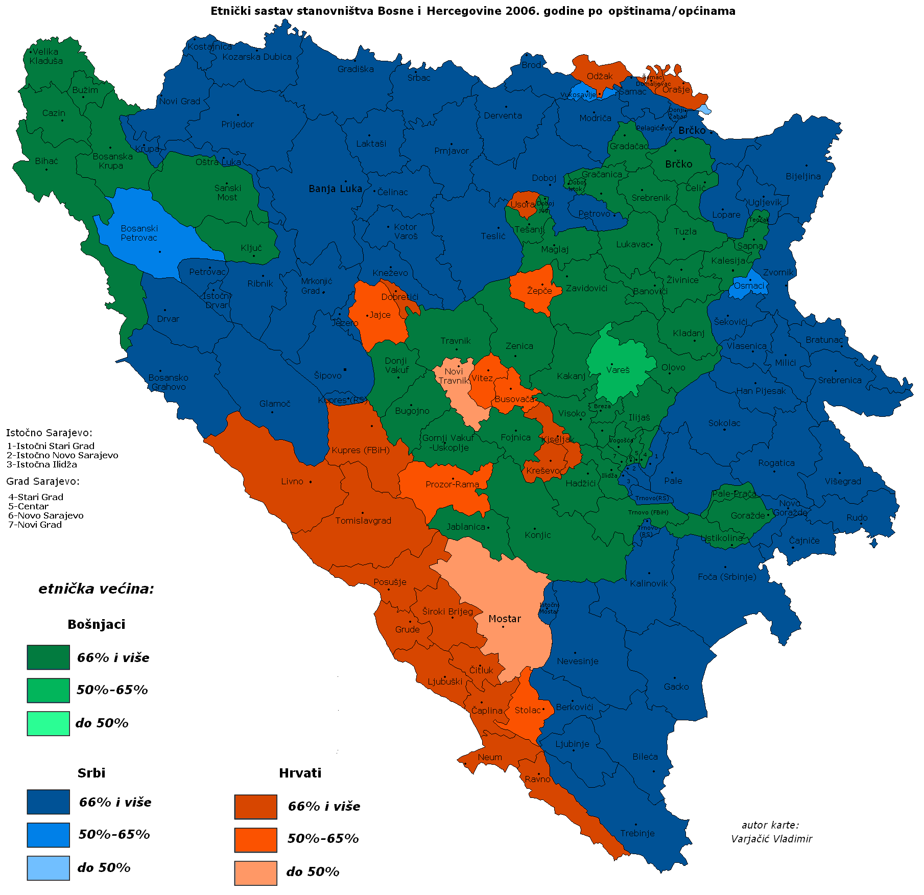
- And this is just corrected Varjačić data. If you look, there is difference (beside municipal corrections) on four areas;
- In Novi Travnik and Mostar where there was apsolute, not relative majority (percentage of other was to small to make a difference)
- In Brčko there was one municipality, not two, and accordingly to that Serbs had relative majority.
- In Glamoč there was few percentages of Serbs bellow 2/3 majority, but it still was apsolute majority (I think it was around 64 percent).
- So basicly that are all few minor corrections, nothing more... --Čeha (トーク) 21:17, 21 July 2015 (UTC)
- I'd like to, but... to be honest, with so many reverts, and with multiple versions that changed the data, I'm not really sure what would be the correct place to go back to, and exactly which versions were 'based on' what earlier versions. I'm a bit concerned that if I do it I'll end up destroying the ability to figure out the correct attribution for the changes included in the current version, if it's kept. Revent (トーク) 20:46, 11 July 2015 (UTC)
- Yeah, no I guess we won't get to any compromise and that a discussion for one map is futile. I guess we will have to go with the three maps uploaded with a disputed lable on all of them. Revent, could we move on to the next stage here? (Lilic (トーク) 23:46, 24 July 2015 (UTC)).
- @Lilic: @Ceha: Sorry, personal matters required me to be dealing with things other than wiki issues for a bit. It looks like this argument has settled down, however, and the protection should have expired by now. Hopefully everyone has agreed by now that the 'best' solution is to have multiple versions on Commons, all marked 'disputed', and let the actual 'content' argument be on the local wikis where it belongs. If the absence of a single 'authoritative' third-party source for the data, I think that's the best solution.Revent (トーク)
- Yes, this should be a good solution. --Čeha (トーク) 12:56, 17 October 2015 (UTC)
- I feel that this version should be deleted. But I am too busy to work on that now. The reason for deletion would be that the map is too similar to the original map. Maps in the past have been deleted for that reason - because they are too similar. (Lilic (トーク) 01:27, 19 November 2015 (UTC)).
- And this is the problem. After long discussion it wasn't like you wished it would be, and we are back to beggining. It goes like this for a few years, and every moderator there was told you you were wrong. But you still don't get it/give up? --Čeha (トーク) 12:48, 21 November 2015 (UTC)
- I really don't know what to say to your abrasive lie filled comment. I don't know if it an attempt to troll or what, it's by far one of the weirdest things that I have seen in a while. (Lilic (トーク) 00:35, 3 January 2016 (UTC)).
| このファイルは2016年12月11日に削除が依頼されましたが存続となりました。 そのときの削除に関する議論がこちらにありますので、再度削除依頼をしようとする場合は考慮にお入れください。 |