File:Колишня Волинська губернія 1925.jpg
Jump to navigation
Jump to search

Size of this preview: 600 × 600 pixels. Other resolutions: 240 × 240 pixels | 480 × 480 pixels | 768 × 768 pixels | 1,024 × 1,024 pixels | 1,401 × 1,401 pixels.
Original file (1,401 × 1,401 pixels, file size: 1.98 MB, MIME type: image/jpeg)
Captions
Captions
Add a one-line explanation of what this file represents
Summary[edit]
| Description |
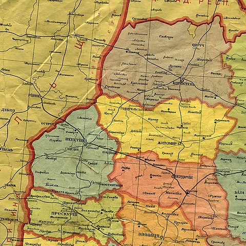
Українська: Територія колишньої Волинської губернії, фрагмент мапи Української соц. рад. республіки, адміністративний поділ від 1 жовтня 1925 |
| Date | |
| Source | Адміністраційна карта Української Соціялістичної Радянської Республіки : адм. границі на 1 жовт. 1925 р. / Картогр. ч. Наркомвнусправ, Народ. Комісаріят Внутр. Справ У.С.Р.Р. — Офіц. вид. — 1:1 250 000. — [X.] : Народ. Комісаріят Внутр. Справ У.С.Р.Р., [1926]. — 1 к.: кольор., герб, штемпель ; 82×105 см (НБУВ СК 15175) |
| Author | Unknown author (scan by AMY, 2017-01-25) |
Licensing[edit]
This file is a Ukrainian or Ukrainian SSR work and it is presently in the public domain in Ukraine, because it was published before January 1, 1954, and the creator (if known) died before that date (details).
|
 |
File history
Click on a date/time to view the file as it appeared at that time.
| Date/Time | Thumbnail | Dimensions | User | Comment | |
|---|---|---|---|---|---|
| current | 19:35, 12 August 2018 | | 1,401 × 1,401 (1.98 MB) | AMY 81-412 (talk | contribs) | == {{int:filedesc}} == {{Information |description={{uk|1=Територія колишньої Волинської губернії, фрагмент мапи Української соц. рад. республіки, адміністративний поділ від 1 жовтня 1925}} |date=1925-10-01 |source= Адміністраційна карта Української Соціялістичної Радянської Республіки : адм. границі на 1 жовт. 1925 р. / Картогр. ч. Наркомвнусправ, Народ. Комісаріят Внутр. Справ У.С.Р.Р. — Офіц. вид. — 1:1 250 000. — [X.] : Народ. Комісаріят Внутр. Справ У.С.Р.Р., [1926]. — 1 к.: кольор., герб... |
You cannot overwrite this file.
File usage on Commons
There are no pages that use this file.
File usage on other wikis
The following other wikis use this file:
- Usage on uk.wikipedia.org