File:1579 Ortelius Map of Calais and Vermandois, France and Vicinity - Geographicus - Calais-ortelius-1579.jpg
Jump to navigation
Jump to search

Size of this preview: 800 × 560 pixels. Other resolutions: 320 × 224 pixels | 640 × 448 pixels | 1,024 × 716 pixels | 1,280 × 895 pixels | 2,560 × 1,790 pixels | 5,000 × 3,497 pixels.
Original file (5,000 × 3,497 pixels, file size: 3.3 MB, MIME type: image/jpeg)
Captions
Captions
Add a one-line explanation of what this file represents
Summary[edit]
| Abraham Ortelius: Caletensium et Bononiensium Ditionis Accurata Delinatio. - Veromanduorum Eorumque Confinium Exactissima Discriptio.
( |
||||||||||||||||||||||||
|---|---|---|---|---|---|---|---|---|---|---|---|---|---|---|---|---|---|---|---|---|---|---|---|---|
| Artist |
|
|||||||||||||||||||||||
| Title |
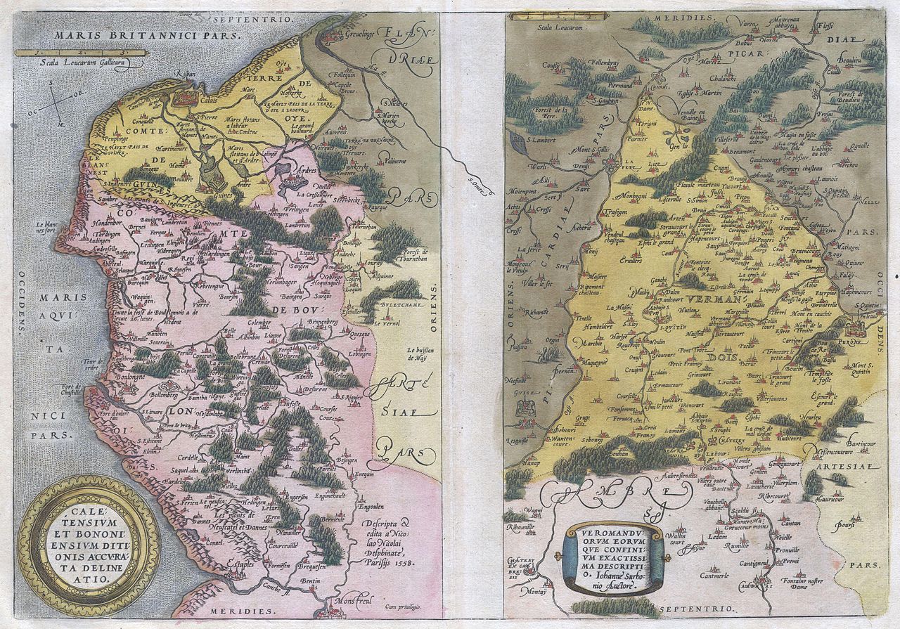
Caletensium et Bononiensium Ditionis Accurata Delinatio. - Veromanduorum Eorumque Confinium Exactissima Discriptio. |
|||||||||||||||||||||||
| Description |
English: Two rare regional Abraham Ortelius maps on a single folio sheet. Left map, entitled Caletensium,depicts the French and Belgian coastline from Estables to Calais. Cartographically based upon a four sheet map issued by Nicholas de Nicolay. The right map, entitled Veromandorum, depicts the immediate vicinity of Saint-Quentin in northern France. This map is based upon the cartographic work of Jean de Surhon who was commissioned by the crown to map the region in 1557. Each map features a decorative title cartouche in the lower left quadrant. Both maps show their respective regions in wonderful detail with attention to forest cities, roads, rivers and villages. Published in Antwerp by A. Ortelius in 1579 for issue in his seminal atlas Theatrum Orbis Terrarum. |
|||||||||||||||||||||||
| Date | 1579 (undated) | |||||||||||||||||||||||
| Dimensions | height: 13 in (33 cm); width: 19 in (48.2 cm) | |||||||||||||||||||||||
| Accession number |
Geographicus link: Calais-ortelius-1579 |
|||||||||||||||||||||||
| Source/Photographer |
|
|||||||||||||||||||||||
| Permission (Reusing this file) |
|
|||||||||||||||||||||||
| Other versions |
|
|||||||||||||||||||||||


File history
Click on a date/time to view the file as it appeared at that time.
| Date/Time | Thumbnail | Dimensions | User | Comment | |
|---|---|---|---|---|---|
| current | 12:27, 16 March 2011 | | 5,000 × 3,497 (3.3 MB) | BotMultichill (talk | contribs) | {{subst:User:Multichill/Geographicus |link=http://www.geographicus.com/P/AntiqueMap/Calais-ortelius-1579 |product_name=1579 Ortelius Map of Calais and Vermandois, France and Vicinity |map_title=Caletensium et Bononiensium Ditionis Accurata Delinatio. - Ve |
You cannot overwrite this file.
File usage on Commons
The following 2 pages use this file:
File usage on other wikis
The following other wikis use this file:
- Usage on de.wikipedia.org
- Usage on ro.wikipedia.org