File:16th century Portuguese Spanish trade routes.png
둘러보기로 이동
검색으로 이동

미리 보기 크기: 800 × 335 픽셀 다른 해상도: 320 × 134 픽셀 | 640 × 268 픽셀 | 1,024 × 429 픽셀 | 1,280 × 536 픽셀 | 2,835 × 1,188 픽셀
원본 파일 (2,835 × 1,188 픽셀, 파일 크기: 2 MB, MIME 종류: image/png)
캡션
설명
이 파일이 나타내는 바에 대한 한 줄 설명을 추가합니다
| 설명 |
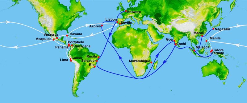
Map showing main Portuguese (blue) and Spanish (white) oceanic trade routes in the 16th century, as a result of the exploration during the Age of Discovery.
|
| 날짜 | (UTC) |
| 출처 | |
| 저자 |
|
| 이 그림은 수정된 그림으로, 원래 그림에서 디지털 변환이 이루어진 그림입니다. 수정 사항 : depiction of 16th century Portuguese and Spanish trade routes. 원래의 그림 : World Topography.jpg:
|
This image uses high-resolution digital topography data from NASA's Shuttle Radar Topography Mission (SRTM) at JPL-Caltech [1]. It is in the public domain in the United States.
|
 | |
기존 올리기 기록[편집]
This image is a derivative work of the following images:
- File:World_Topography.jpg licensed with PD-USGov-NASA-SRTM
- 2009-03-17T12:12:25Z Sk 21600x9049 (17145460 Bytes) {{Information |Description=PIA03395: World in Mercator Projection, Shaded Relief and Colored Height |Source=http://photojournal.jpl.nasa.gov/catalog/PIA03395 |Date=February 2000 |Author=NASA/JPL/NIMA |Permission={{PD-USGov-
Uploaded with derivativeFX
파일 역사
날짜/시간 링크를 클릭하면 해당 시간의 파일을 볼 수 있습니다.
| 날짜/시간 | 섬네일 | 크기 | 사용자 | 설명 | |
|---|---|---|---|---|---|
| 현재 | 2023년 7월 15일 (토) 23:50 | | 2,835 × 1,188 (2 MB) | Hohum (토론 | 기여) | Brighten |
| 2013년 2월 17일 (일) 20:21 |  | 2,835 × 1,188 (745 KB) | JohnnyMrNinja (토론 | 기여) | remove unused alpha, indexed colors and increased compression (reduced size about 3x) | |
| 2012년 1월 16일 (월) 23:00 |  | 2,835 × 1,188 (2.45 MB) | Uxbona (토론 | 기여) | restored missing route to Antwerp | |
| 2012년 1월 16일 (월) 11:00 |  | 2,835 × 1,188 (2.45 MB) | Uxbona (토론 | 기여) | restored missing outbound route | |
| 2012년 1월 12일 (목) 19:16 |  | 2,835 × 1,188 (2.45 MB) | Uxbona (토론 | 기여) | corrected locations and typo (Seville, Salvador, Manila) | |
| 2011년 9월 4일 (일) 00:06 |  | 3,000 × 1,257 (2.66 MB) | Uxbona (토론 | 기여) | (Added Callao after comment, and Antwerp - as those are relevant stopovers. Detailed Brazilian Salvador and Pernambuco stopovers.) | |
| 2011년 9월 4일 (일) 00:02 |  | 11,812 × 4,950 (7.84 MB) | Uxbona (토론 | 기여) | Reverted to version as of 23:57, 3 September 2011 | |
| 2011년 9월 4일 (일) 00:02 |  | 5,906 × 2,475 (7.52 MB) | Uxbona (토론 | 기여) | (Added Callao after comment, and Antwerp - as those are relevant stopovers. Detailed Brazilian Salvador, Pernambuco and Cochi stopovers.) | |
| 2011년 9월 3일 (토) 23:57 |  | 11,812 × 4,950 (7.84 MB) | Uxbona (토론 | 기여) | Added Callao after comment, and Antwerp - as those are relevant stopovers. Detailed Brazilian Salvador and Pernambuco stopovers. | |
| 2010년 9월 7일 (화) 08:13 |  | 2,953 × 1,225 (2.4 MB) | Uxbona (토론 | 기여) | add Mozambique stopover |
이 파일을 덮어쓸 수 없습니다.
이 파일을 사용하는 문서
다음 문서 3개가 이 파일을 사용하고 있습니다:
이 파일을 사용하고 있는 모든 위키의 문서 목록
다음 위키에서 이 파일을 사용하고 있습니다:
- ar.wikipedia.org에서 이 파일을 사용하고 있는 문서 목록
- azb.wikipedia.org에서 이 파일을 사용하고 있는 문서 목록
- ca.wikipedia.org에서 이 파일을 사용하고 있는 문서 목록
- de.wikipedia.org에서 이 파일을 사용하고 있는 문서 목록
- el.wikipedia.org에서 이 파일을 사용하고 있는 문서 목록
- en.wikipedia.org에서 이 파일을 사용하고 있는 문서 목록
- Acapulco
- Colonialism
- Privateer
- New Spain
- Treaty of Tordesillas
- Piracy in the Caribbean
- Conquistador
- Spice trade
- Manila galleon
- Trade route
- Age of Discovery
- Spanish treasure fleet
- Asiento de Negros
- Sea lane
- Filipinos
- Filipino nationalism
- Volta do mar
- List of World Heritage Sites in Mexico
- Marine navigation
- Winds in the Age of Sail
- User:Uxbona
- Iberian ship development, 1400–1600
- Exploration of the Pacific
- User:StAnMc18/sandbox
- Political economy in anthropology
- Global silver trade from the 16th to 19th centuries
- Maritime Silk Road
- Jorge Cabral
- 1557 influenza pandemic
- User:Goatmanatee/Spanish treasure fleet
- User:Goatmanatee/Manila galleon
- Economic history of Latin America
- es.wikipedia.org에서 이 파일을 사용하고 있는 문서 목록
이 파일의 더 많은 사용 내역을 봅니다.
메타데이터
분류:
- Maps showing 16th-century history
- Maps of trade routes
- Maps of maritime history
- Maps of the history of colonies of Portugal
- Maps of the Viceroyalty of New Spain
- Manila galleon
- Maps of the Captaincy General of the Philippines
- Age of Discovery
- Asia in the 16th century
- Cuba in the 16th century
- Europe in the 16th century
- Mexico in the 16th century
- Portugal in the 16th century
- South America in the 16th century
- Spain in the 16th century
- Maps of Spanish trade routes
- Iberian ship development, 1400–1600
- Maps of the world with Mercator projection