File:1772 Vaugondy - Diderot Map of California in five states, California as Island. - Geographicus - CalifornieSuivant2-vaugondy-1768.jpg
Vai alla navigazione
Vai alla ricerca
Dimensioni di questa anteprima: 738 × 599 pixel. Altre risoluzioni: 296 × 240 pixel | 591 × 480 pixel | 946 × 768 pixel | 1 261 × 1 024 pixel | 2 521 × 2 048 pixel | 3 500 × 2 843 pixel.
File originale (3 500 × 2 843 pixel, dimensione del file: 2,67 MB, tipo MIME: image/jpeg)
Didascalie
Didascalie
Aggiungi una brevissima spiegazione di ciò che questo file rappresenta
| Artista | ||||||
| Titolo |
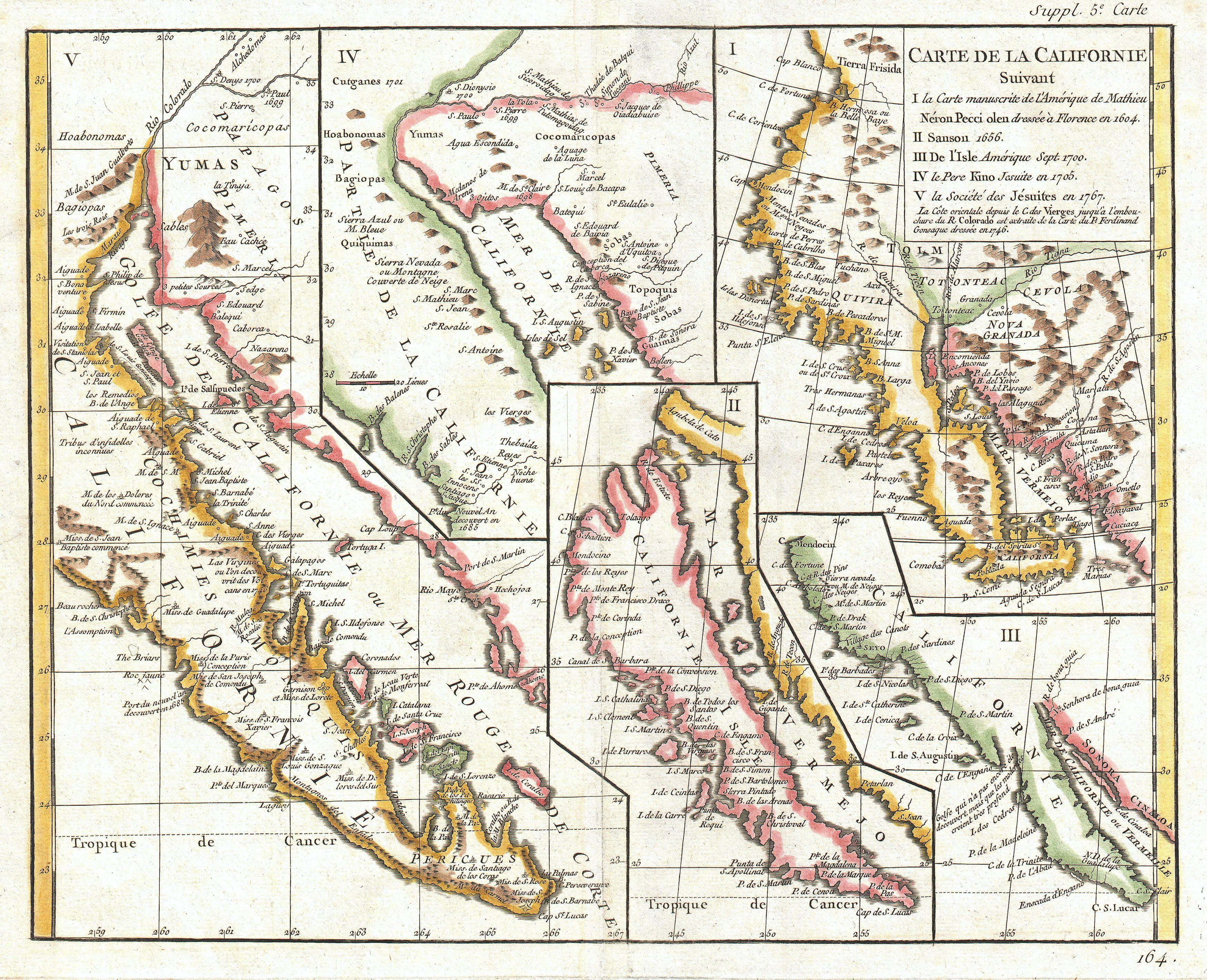
Carte de la Californie suivant - I. La carte manuscrite de l'Amérique de Mathieu Néron Pecci olen dresse à Florence en 1604 - II. Sanson 1656 - III. De L'Isle Amérique Sept. 1700 - IV. le Pere Kino Jesuite en 1705 - V. La Societe des Jésuites en 1767. |
|||||
| Descrizione |
English: A rare and important map of California in five different states, ranging from roughly 1656 to 1767. Engraved by the important French cartographer Robert De Vaugondy, for the c. 1770 edition of the Denis Diderot (1713-84) Encyclopedie . This map explores the confused state of California cartography in the late 18th century. Examines the gradual discovery of California through various seminal mappings. Initially uses the work of Italian cartographer Matheau Neron Pecci (1604) which correctly presumed that the main body of California extended southward into a peninsula. The next map illustrated, by N. Sanson in 1656, displays in insular California. Map no. III, by Guillaume de L'Isle (1700) reattaches California to the mainland, returning to the early peninsular theory. Next, Vaugondy exhibits part of the seminal Kino Map. This map, rendered by a Jesuit missionary c. 1705 was the work that finally disproved the California Insular theory. Father Franz Kino walked this region between 1698 and 1701. The final map, produced by unnamed Jesuits c. 1767 is a somewhat accurate depiction of the Baja California peninsula. These maps all predate the discoveries of Captain Cook’s voyages and hence Diderot’s work was as much speculative as historical. A fine example of an essential work for all serious California collections. This map is part of the 10 map series prepared by Vaugondy for the Supplement to Diderot’s Encyclopédie , of which this is plate 5. This seminal map series, exploring the mapping of North American and specifically the Northwest Passage was one of the first studies in comparative cartography. |
|||||
| Data | 1770 circa(undated) | |||||
| Dimensioni | altezza: 11,5 pollici (29,2 cm); larghezza: 15 pollici (38,1 cm) | |||||
| Numero d'inventario |
Geographicus link: CalifornieSuivant2-vaugondy-1768 |
|||||
| Fonte/Fotografo |
Supplement to Diderot's Encyclopédie, ou dictionnaire raisonné des sciences, des arts et des métiers. or Vaugondy's Recueil de 10 Cartes Traitant Particulierement de L'Amerique du Nord, (1779).
|
|||||
| Licenza (Riusare questo file) |
|
|||||
Cronologia del file
Fare clic su un gruppo data/ora per vedere il file come si presentava nel momento indicato.
| Data/Ora | Miniatura | Dimensioni | Utente | Commento | |
|---|---|---|---|---|---|
| attuale | 19:06, 17 mar 2011 | | 3 500 × 2 843 (2,67 MB) | BotMultichill (discussione | contributi) | {{subst:User:Multichill/Geographicus |link=http://www.geographicus.com/P/AntiqueMap/CalifornieSuivant2-vaugondy-1768 |product_name=1772 Vaugondy - Diderot Map of California in five states, California as Island. |map_title=Carte de la Californie suivant - |
Impossibile sovrascrivere questo file.
Utilizzo del file
La seguente pagina usa questo file:
Utilizzo globale del file
Anche i seguenti wiki usano questo file:
- Usato nelle seguenti pagine di es.wikipedia.org:
- Usato nelle seguenti pagine di it.wikipedia.org: