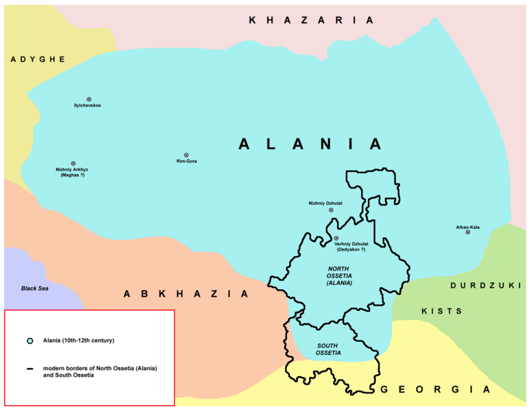
File:Alania 10th–12th c. according to Bzarov.png
Da Wikimedia Commons, l'archivio di file multimediali liberi
Vai alla navigazione
Vai alla ricerca

Dimensioni di questa anteprima: 775 × 600 pixel. Altre risoluzioni: 310 × 240 pixel | 621 × 480 pixel | 993 × 768 pixel | 1 280 × 990 pixel | 1 656 × 1 281 pixel.
File originale (1 656 × 1 281 pixel, dimensione del file: 83 KB, tipo MIME: image/png)
Informazioni sul file
Dati strutturati
Didascalie
Didascalie
Aggiungi una brevissima spiegazione di ciò che questo file rappresenta
L’effettiva accuratezza di questa carta è messa in discussione.
Motivo: per favore vedi la discussione relativa nella pagina di discussione. |  |
Dettagli
[modifica]| DescrizioneAlania 10th–12th c. according to Bzarov.png |
English: Borders of modern North Ossetia (Alania) and South Ossetia compared with borders of medieval Alania (10th-12th century) - according to Ossetian historian Ruslan Suleymanovich Bzarov. |
| Data | 6 giugno 2009 (data di caricamento originaria) |
| Fonte | Nessuna fonte leggibile automaticamente. Presunta opera propria (secondo quanto affermano i diritti d'autore). |
| Autore | Nessun autore leggibile automaticamente. PANONIAN presunto (secondo quanto affermano i diritti d'autore). |
Sources
[modifica]Made according to these history maps from internet:
- map from www.alanica.ru: http://www.alanica.ru/images/map/alan3.jpg Archived 2012-07-22 at Archive.today - the map is linked from this page: http://www.alanica.ru/map/index.htm - according to that page, these maps originally came from this book: "Исторический атлас Осетии" (Отв. ред. Р.С. Бзаров)., Владикавказ, изд. "Ремарко", 2002 г. - here is translation of this page into English: http://translate.google.com/translate?hl=en&sl=ru&u=http://www.alanica.ru/map/index.htm&ei=cy1aSq3NHpLFsga6rInWAw&sa=X&oi=translate&resnum=8&ct=result&prev=/search%3Fq%3D%25D0%2591%25D0%25B7%25D0%25B0%25D1%2580%25D0%25BE%25D0%25B2%2B%25D0%25B0%25D1%2582%25D0%25BB%25D0%25B0%25D1%2581%26hl%3Den%26sa%3DG and English name of the original book source: "Historical Atlas of Ossetia (Отв. Ed. Bzarov RS)., Vladikavkaz, ed." Remarque ", 2002
- map from www.aors.narod.ru: http://www.aors.narod.ru/images/Al-VII.gif - the map is linked from this page: http://www.aors.narod.ru/Texty/AlyVII-XII.htm Here is bibliography of this web site: http://www.aors.narod.ru/Texty/Istochniki.htm - history maps probably came from this history atlas listed in bibliography: "Исторический атлас Осетии / Отв. ред. Р.С. Бзаров - Владикавказ: Ремарко, 2002 - 48 с. ил."
- map from iratta.com: http://iratta.com/uploads/posts/atlas/09/karta.jpg - the map is linked from this page: http://iratta.com/2007/03/03/alanija_v_viixii_vv.html
- map from fandag.ru: http://fandag.ru/load/9-1-0-56
- map from www.iriston.com: http://www.iriston.com/books/cuciev_-_etno_atlas/maps/map46.jpg (Ethno Atlas, Cuciev)
Licenza
[modifica]self-made map by user:PANONIAN
| Public domainPublic domainfalsefalse |
| Io, detentore del copyright su quest'opera, la rilascio nel pubblico dominio. Questa norma si applica in tutto il mondo. In alcuni paesi questo potrebbe non essere legalmente possibile. In tal caso: Garantisco a chiunque il diritto di utilizzare quest'opera per qualsiasi scopo, senza alcuna condizione, a meno che tali condizioni siano richieste dalla legge. |
Cronologia del file
Fare clic su un gruppo data/ora per vedere il file come si presentava nel momento indicato.
| Data/Ora | Miniatura | Dimensioni | Utente | Commento | |
|---|---|---|---|---|---|
| attuale | 08:54, 18 apr 2020 |  | 1 656 × 1 281 (83 KB) | PANONIAN (discussione | contributi) | Reverted to version as of 19:47, 26 April 2014 (UTC) - please upload your version under different filename |
| 12:45, 25 mar 2020 |  | 1 656 × 1 281 (85 KB) | Ercwlff (discussione | contributi) | Adjusted the bottom part after Ian Mladjov's maps | |
| 19:47, 26 apr 2014 |  | 1 656 × 1 281 (83 KB) | PANONIAN (discussione | contributi) | aesthetics | |
| 17:02, 19 mag 2013 |  | 1 659 × 1 281 (83 KB) | PANONIAN (discussione | contributi) | Reverted to version as of 13:54, 6 June 2009 - please upload your version under different name. these names are in accordance with sources | |
| 00:24, 19 mag 2013 |  | 1 659 × 1 281 (91 KB) | Giorgi Balakhadze (discussione | contributi) | Edited names of kingdoms. | |
| 00:22, 19 mag 2013 |  | 1 659 × 1 281 (91 KB) | Giorgi Balakhadze (discussione | contributi) | Edited names of kingdoms. | |
| 13:54, 6 giu 2009 |  | 1 659 × 1 281 (83 KB) | PANONIAN (discussione | contributi) | ==Description== Borders of modern North Osseria (Alania) and South Ossetia compared with borders of medieval Alania (10th-12th century) ==Licence== self-made map by user:PANONIAN {{PD-self|PANONIAN}} Category:Maps of the history of Caucasus [[Categ |
Impossibile sovrascrivere questo file.
Utilizzo del file
Le seguenti 9 pagine usano questo file:
Utilizzo globale del file
Anche i seguenti wiki usano questo file:
- Usato nelle seguenti pagine di an.wikipedia.org:
- Usato nelle seguenti pagine di azb.wikipedia.org:
- Usato nelle seguenti pagine di az.wikipedia.org:
- Usato nelle seguenti pagine di bg.wikipedia.org:
- Usato nelle seguenti pagine di ca.wikipedia.org:
- Usato nelle seguenti pagine di cs.wikipedia.org:
- Usato nelle seguenti pagine di de.wikipedia.org:
- Usato nelle seguenti pagine di el.wikipedia.org:
- Usato nelle seguenti pagine di en.wikipedia.org:
- Usato nelle seguenti pagine di et.wikipedia.org:
- Usato nelle seguenti pagine di eu.wikipedia.org:
- Usato nelle seguenti pagine di fa.wikipedia.org:
- Usato nelle seguenti pagine di fi.wikipedia.org:
- Usato nelle seguenti pagine di fr.wikipedia.org:
- Usato nelle seguenti pagine di gl.wikipedia.org:
- Usato nelle seguenti pagine di hr.wikipedia.org:
- Usato nelle seguenti pagine di hu.wikipedia.org:
- Usato nelle seguenti pagine di hy.wikipedia.org:
- Usato nelle seguenti pagine di id.wikipedia.org:
- Usato nelle seguenti pagine di it.wikipedia.org:
- Usato nelle seguenti pagine di ja.wikipedia.org:
- Usato nelle seguenti pagine di kbd.wikipedia.org:
- Usato nelle seguenti pagine di kk.wikipedia.org:
- Usato nelle seguenti pagine di ky.wikipedia.org:
- Usato nelle seguenti pagine di lv.wikipedia.org:
- Usato nelle seguenti pagine di mg.wikipedia.org:
- Usato nelle seguenti pagine di mk.wikipedia.org:
- Usato nelle seguenti pagine di mn.wikipedia.org:
- Usato nelle seguenti pagine di ms.wikipedia.org:
- Usato nelle seguenti pagine di mwl.wikipedia.org:
- Usato nelle seguenti pagine di nn.wikipedia.org:
- Usato nelle seguenti pagine di no.wikipedia.org:
Visualizza l'utilizzo globale di questo file.