File:Austria-Hungary map.svg
Vai alla navigazione
Vai alla ricerca

Dimensioni di questa anteprima PNG per questo file SVG: 776 × 600 pixel. Altre risoluzioni: 311 × 240 pixel | 621 × 480 pixel | 994 × 768 pixel | 1 280 × 989 pixel | 2 560 × 1 978 pixel | 783 × 605 pixel.
File originale (file in formato SVG, dimensioni nominali 783 × 605 pixel, dimensione del file: 331 KB)
Didascalie
Didascalie
Aggiungi una brevissima spiegazione di ciò che questo file rappresenta

Dettagli
[modifica]| Descrizione |
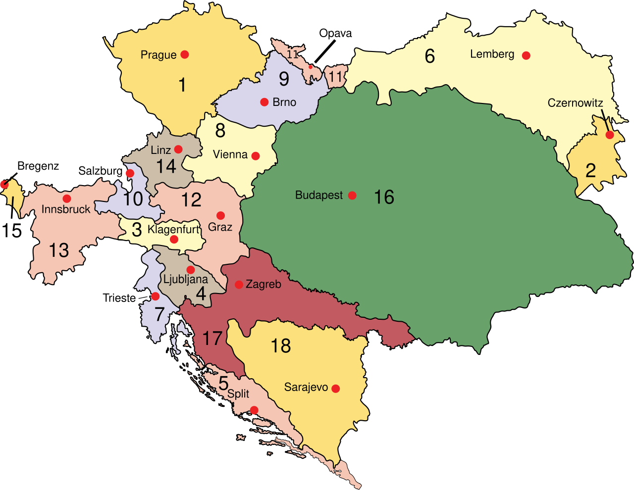
English: Austria
Deutsch: Österreich 1910
Esperanto: Aŭstrio 1910
Magyar: Ausztria
Latina: Austria:
Македонски: Австрија
Polski: Austro–Węgry
Svenska: Österrike-Ungern
Français : Autriche-Hongrie
Čeština: Rakousko-Uhersko
Slovenščina: Avstro-Ogrska
|
| Data | |
| Fonte | Opera propria (at English wikipedia) |
| Autore | IMeowbot |
| Altre versioni |
[]
Opere derivate da questo file:
|
| SVG sviluppo | Il codice sorgente di questo file SVG non è valido a causa di 54 errori. Questa mappa in grafica vettoriale non valida secondo il W3C è stata creata con Inkscape…importante. |


Licenza
[modifica]
| |
Questa immagine è stata rilasciata nel pubblico dominio dal suo autore, IMeowbot nel progetto Wikimedia Commons. Questa norma si applica in tutto il mondo. Nel caso in cui questo non sia legalmente possibile: |
Cronologia del file
Fare clic su un gruppo data/ora per vedere il file come si presentava nel momento indicato.
| Data/Ora | Miniatura | Dimensioni | Utente | Commento | |
|---|---|---|---|---|---|
| attuale | 12:54, 14 ago 2012 | | 783 × 605 (331 KB) | DIREKTOR (discussione | contributi) | Softer shade of green for Hungary proper, desaturated red for the Kingdom of Croatia-Slavonia (Horvát-Szlavón Királyság). |
| 16:44, 3 feb 2011 |  | 783 × 605 (331 KB) | Vearthy (discussione | contributi) | Kingdom of Hungary back in green, changed too strong orange to a bit lighter, pastel color | |
| 22:48, 16 apr 2010 |  | 783 × 605 (331 KB) | Vearthy (discussione | contributi) | changed colours | |
| 22:49, 14 set 2009 |  | 783 × 605 (331 KB) | Kirk979 (discussione | contributi) | english names of capitals | |
| 22:41, 14 set 2009 |  | 783 × 605 (331 KB) | Kirk979 (discussione | contributi) | correctioons | |
| 21:00, 9 ago 2009 |  | 783 × 605 (315 KB) | Gugganij (discussione | contributi) | Reverted to version as of 19:00, 24 July 2009, reason: the province "Küstenland" was blackened | |
| 22:13, 25 lug 2009 |  | 800 × 640 (274 KB) | Cäsium137~commonswiki (discussione | contributi) | Valid IDs | |
| 23:41, 24 lug 2009 |  | 800 × 640 (274 KB) | Cäsium137~commonswiki (discussione | contributi) | smooth | |
| 19:00, 24 lug 2009 |  | 783 × 605 (315 KB) | Hk kng (discussione | contributi) | a bit of cleanup | |
| 18:32, 24 lug 2009 |  | 783 × 605 (319 KB) | Hk kng (discussione | contributi) | testing whether using another font helps |
Impossibile sovrascrivere questo file.
Utilizzo del file
Le seguenti 24 pagine usano questo file:
- Atlas of Austria
- Atlas of Austria-Hungary
- Atlas of Bosnia and Herzegovina
- Atlas of Hungary
- Atlas of Poland
- Atlas of Slovakia
- Atlas of Slovenia
- Atlas of Székely Land
- Atlas of Ukraine
- Atlas of the Czech Republic
- Magyarország
- File:Austria-Hungary map-pl.svg
- File:Austria-Hungary map-sl.svg
- File:Austria-Hungary map.svg
- File:Austria-Hungary map cs.svg
- File:Austria-Hungary map de.svg
- File:Austria-Hungary map hr.svg
- File:Austria-Hungary map hu.svg
- File:Austria-Hungary map mk.svg
- File:Austria-Hungary map new.svg
- File:Austria-Hungary map sr.svg
- File:Flag map of the Austro-Hungarian Empire (habsburg flag).svg
- Template:Other versions/Austria-Hungary map
- Category:Greater Hungary
.svg)
Utilizzo globale del file
Anche i seguenti wiki usano questo file:
- Usato nelle seguenti pagine di ar.wikipedia.org:
- Usato nelle seguenti pagine di azb.wikipedia.org:
- Usato nelle seguenti pagine di be-tarask.wikipedia.org:
- Usato nelle seguenti pagine di be.wikipedia.org:
- Usato nelle seguenti pagine di bn.wikipedia.org:
- Usato nelle seguenti pagine di bn.wikibooks.org:
- Usato nelle seguenti pagine di bs.wikipedia.org:
- Usato nelle seguenti pagine di bxr.wikipedia.org:
- Usato nelle seguenti pagine di ca.wikipedia.org:
- Usato nelle seguenti pagine di cs.wikipedia.org:
- Usato nelle seguenti pagine di da.wikipedia.org:
- Usato nelle seguenti pagine di de.wikipedia.org:
- Usato nelle seguenti pagine di de.wikibooks.org:
- Usato nelle seguenti pagine di el.wikipedia.org:
- Usato nelle seguenti pagine di en.wikipedia.org:
- Hungary
- Carniola
- History of Styria
- Bay of Kotor
- Cisleithania
- Kingdom of Croatia-Slavonia
- Lands of the Crown of Saint Stephen
- History of Transylvania
- List of irredentist claims or disputes
- Wikipedia:WikiProject Former countries/Austria-Hungary task force
- Wikipedia:Reference desk/Archives/Humanities/2010 November 19
- List of World War I flying aces from Austria-Hungary
- User:Falcaorib/Austria-Hungary
- Usato nelle seguenti pagine di en.wikibooks.org:
- Usato nelle seguenti pagine di en.wikivoyage.org:
- Usato nelle seguenti pagine di en.wiktionary.org:
- Usato nelle seguenti pagine di eo.wikipedia.org:
Visualizza l'utilizzo globale di questo file.