File:Banat Josephinische Landaufnahme pg168.jpg
Jump to navigation
Jump to search

Size of this preview: 800 × 541 pixels. Other resolutions: 320 × 216 pixels | 640 × 433 pixels | 1,024 × 692 pixels | 1,280 × 865 pixels | 2,560 × 1,730 pixels | 8,446 × 5,708 pixels.
Original file (8,446 × 5,708 pixels, file size: 29.19 MB, MIME type: image/jpeg)
Captions
Captions
Add a one-line explanation of what this file represents
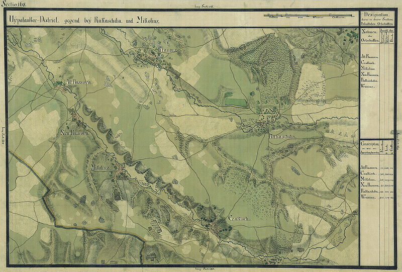
| Name shown on the map Nume din hartă |
Administrative unit Unitate administrativă |
Romanian name Numele românesc |
Hungarian name Numele unguresc |
German name Numele german |
Serbian name Numele sârbesc |
Country today Ţara de astăzi |
|---|---|---|---|---|---|---|
| Alt Russova | Krassó megye | Rusova Veche | Óruszolc, Óruszova | Alt- Ruschowa | Románia | |
| Czukisch | Krassó megye | Ciuchici | Tyukó | Románia | ||
| Mikolinz | Krassó megye | Nicolinţ | Miklósháza, Nikolinc | Románia | ||
| Neu Russova | Krassó megye | Rusova Nouă | Újruszolc, Újruszova | Neu-Ruschowa | Románia | |
| Rakaschdia | Krassó megye | Răcăşdia | Rakasd, Rakasdia | Románia | ||
| Wraniuz | Krassó megye | Vrăniuţ | Felsővarány, Vranyuc | Romania |
Summary
[edit]
| Description |
Deutsch: Das Banat in: Josephinische Landesaufnahme, 1769-72. Josephinische Landaufnahme pg168 English: The Banat region in the cadastral maps: Josephinische Landesaufnahme, 1769-72. Josephinische Landaufnahme pg168 |
||||
| Date | between 1769 and 1772 | ||||
| Source | Österreichisches Staatsarchiv, Kriegsarchiv | ||||
| Author | Historische Militärkarte der österreichisch-ungarischen Monarchie | ||||
| Permission (Reusing this file) |
|
||||
Clickable map of the Banat region
[edit]

File history
Click on a date/time to view the file as it appeared at that time.
| Date/Time | Thumbnail | Dimensions | User | Comment | |
|---|---|---|---|---|---|
| current | 06:56, 5 January 2010 | | 8,446 × 5,708 (29.19 MB) | Asybaris01 (talk | contribs) | {{Information |Description={{ro|1=Banat Josephinische Landaufnahme pg168}} |Source={{own}} |Author=Asybaris01 |Date=1769-72 |Permission= |other_versions= }} Category:Josephinische Landaufnahme |
You cannot overwrite this file.
File usage on Commons
There are no pages that use this file.
File usage on other wikis
The following other wikis use this file:
- Usage on arz.wikipedia.org
- Usage on ceb.wikipedia.org
- Usage on ce.wikipedia.org
- Usage on de.wikipedia.org
- Usage on eo.wikipedia.org
- Usage on hu.wikipedia.org
- Usage on pl.wikipedia.org
- Usage on ro.wikipedia.org
- Listă de localități din județul Caraș-Severin
- Comuna Ciuchici, Caraș-Severin
- Nicolinț, Caraș-Severin
- Comuna Răcășdia, Caraș-Severin
- Rusova Nouă, Caraș-Severin
- Rusova Veche, Caraș-Severin
- Vrăniuț, Caraș-Severin
- Ciuchici, Caraș-Severin
- Utilizator:Strainu/wlro/Caraș-Severin
- Wikipedia:Wiki Loves România/Caraș-Severin
- Usage on tt.wikipedia.org
- Usage on www.wikidata.org