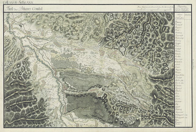
File:BihorSolnocCrasna Josephinische Landesaufnahme pg28-24.jpg
Jump to navigation
Jump to search

Size of this preview: 800 × 538 pixels. Other resolutions: 320 × 215 pixels | 640 × 430 pixels | 1,024 × 688 pixels | 1,280 × 861 pixels | 2,560 × 1,721 pixels | 8,530 × 5,735 pixels.
Original file (8,530 × 5,735 pixels, file size: 29.07 MB, MIME type: image/jpeg)
Captions
Captions
Add a one-line explanation of what this file represents
| Name shown on the map Nume din hartă |
Administrative unit Unitate administrativă |
Romanian name Numele românesc |
Hungarian name Numele unguresc |
German name Numele german |
Country today Ţara de astăzi |
|---|---|---|---|---|---|
| Belesénÿ | Bihar | Belejeni [Belegeni] | Belényeshegy, Belezsény | Romania | |
| Buntÿesd | Bihar | Bunteşti [Bunceşti] | Bontesd, Buntyesd | Romania | |
| Bragÿet | Bihar | Brădet | Biharfenyves, Bragyet | Romania | |
| Brost | Bihar | Stânceşti [Broaşte, Stânceştii] | Kisbékafalva, Békafalva, Brost | Romania | |
| Balalenÿ | Bihar | Băleni [Bălăleni] | Balalény | Romania | |
| Draganiest | Bihar | Drăgăneşti | Dragánfalva, Dragonyesd | Romania | |
| Dombrovánÿ | Bihar | Dumbrăvani | Dombrovány | Romania | |
| Guránÿ | Bihar | Gurani | Gurány | Romania | |
| Gijigÿisen | Bihar | Ghighişeni | Gyegyesény, Gyigyiseny | Romania | |
| Henkeres | Bihar | Hinchiriş | Henkeres | Romania | |
| Hernczest | Bihar | Hârşeşti | Herzafalva, Herzest | Romania | |
| Totorénÿ | Bihar | Totoreni | Tatárfalva | Romania | |
| Kotsuba | Bihar | Cociuba Mică [Cociuba de Sus] | Felsőkocsoba | Romania | |
| Kis Koh | Bihar | Chişcău | Kiskoh, Kiskóh | Romania | |
| Kőszvénÿes | Bihar | Cusuiuş [Cusiiş, Cuşuiuş, Cuşuiş] | Köszvényes | Romania | |
| Kakacsén | Bihar | Cucuceni [Căcăceni] | Kakucsány, Kakacsény | Romania | |
| Lelesd | Bihar | Leleşti | Lelesd | Romania | |
| Lazúr | Bihar | Romania | |||
| Magura | Bihar | Măgura | Biharmagura, Magura | Romania | |
| Miragu | Bihar | Mierag | Mérág | Romania | |
| Nÿegerfalva | Bihar | Grădinari [Negru, Grădinarii] | Kisnyégerfalva, Nyégerfalva | Romania | |
| Pakanest | Bihar | Păcăleşti | Pakala | Romania | |
| Pojen de Joz | Bihar | Poienii de Jos [Poenii de Jos, Poienile de Jos, Poiana de Jos] | Alsópojény, Alsópoeny | Romania | |
| Pojen de Suz | Bihar | Poienii de Sus [Poenii de Sus, Poienile de Sus, Poiana de Sus] | Felsőpojény, Felsőpoeny | Romania | |
| Petrócz | Bihar | Pietroasa [Petroasa, Pietros] | Vasaskőfalva, Petrosz | Romania | |
| Poganiest | Bihar | Romania | |||
| Petrilen | Bihar | Petrileni [Zăvoieni, Petrileni-Zăvoieni] | Petrelény, Petrelényzavoeny | Romania | |
| Rien | Bihar | Rieni | Rény, Rieny, Riény | Romania | |
| Sebes | Bihar | Sebiş | Körössebes, Nagysebes, Sebes | Romania | |
| Szudu | Bihar | Săud | Szód | Romania | |
| Szudrics | Bihar | Sudrigiu [Sudrighiu, Sudrigi] | Kisszedres, Szudrics | Romania | |
| Stej | Bihar | Ştei [Şteiu, Stei, Steiu, Dr. Petru Groza] | Vaskohsziklás, Stej | Romania | |
| Segest | Bihar | Romania | |||
| Tarkanÿ | Bihar | Tărcaia [Tarcaia] | Köröstárkány, Nagytárkány, Tárkány | Romania | |
| Cziganest | Bihar | Ţigăneştii de Beiuş [Ţigăneşti] | Cigányosd | Romania | |
| Valenÿagra de Suz | Bihar | Valea de Sus [Valea Neagră, Valea Neagră de Sus] | Felsőfeketevölgy, Felsőfeketepatak, Felsővalenyágra | Romania | |
| Valenÿagra de Soz | Bihar | Valea de Jos [Valea Neagră, Valea neagră de Jos] | Alsófeketevölgy, Feketepatak, Alsóvalenyágra | Romania | |
| Vojen | Bihar | Romania | |||
| Zavojen | Bihar | Petrileni [Zăvoieni, Petrileni-Zăvoieni] | Petrelény, Petrelényzavoeny | Romania | |
| Fericse | Bihar | Ferice | Fericse | Romania |
Summary[edit]
| Description |
English: Bihor County, 1782-85. Josephinische Landesaufnahme pg.28-24 |
||||
| Date | between 1782 and 1785 | ||||
| Source | Österreichisches Staatsarchiv, Kriegsarchiv | ||||
| Author | Historische Militärkarte der österreichisch-ungarischen Monarchie | ||||
| Permission (Reusing this file) |
|
||||
Clickable Map of the Bihor, Solnoc, Crasna County[edit]

File history
Click on a date/time to view the file as it appeared at that time.
| Date/Time | Thumbnail | Dimensions | User | Comment | |
|---|---|---|---|---|---|
| current | 06:50, 13 April 2010 | | 8,530 × 5,735 (29.07 MB) | Asybaris01 (talk | contribs) | {{Information |Description={{ro|1=erfd}} |Source=dd |Author=sw |Date=12 |Permission= |other_versions= }} Category:Josephinische Landaufnahme |
You cannot overwrite this file.
File usage on Commons
The following page uses this file:
File usage on other wikis
The following other wikis use this file:
- Usage on arz.wikipedia.org
- Usage on hu.wikipedia.org
- Usage on ro.wikipedia.org
View more global usage of this file.