File:Bosporan Kingdom growth map-fr.svg
Jump to navigation
Jump to search

Size of this PNG preview of this SVG file: 675 × 575 pixels. Other resolutions: 282 × 240 pixels | 564 × 480 pixels | 902 × 768 pixels | 1,202 × 1,024 pixels | 2,404 × 2,048 pixels.
Original file (SVG file, nominally 675 × 575 pixels, file size: 1.13 MB)
Captions
Captions
Add a one-line explanation of what this file represents
Summary
[edit]| Description |
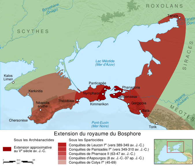
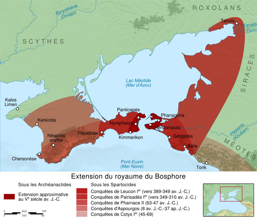
English: Map showing the growth of Bosporan Kingdom under the Spartocids dynasty. Français : Carte montrant l'extension du Royaume du Bosphore sous la dynastie des Spartocides. |
||
| Date | (UTC) | ||
| Source |
Own work. Source:
|
||
| Author | Sémhur (talk) | ||
| Other versions |
[]
| ||
| Attribution (required by the license) | © Sémhur / Wikimedia Commons / | ||
| SVG | W3C-validity not checked.
|
||
| Graphic Lab |


| Object location | | View this and other nearby images on: OpenStreetMap |
|---|
Licensing
[edit]
I, the copyright holder of this work, hereby publish it under the following licenses:
| Copyleft: This work of art is free; you can redistribute it and/or modify it according to terms of the Free Art License. You will find a specimen of this license on the Copyleft Attitude site as well as on other sites. |
This file is licensed under the Creative Commons Attribution-Share Alike 4.0 International, 3.0 Unported, 2.5 Generic, 2.0 Generic and 1.0 Generic license.
- You are free:
- to share – to copy, distribute and transmit the work
- to remix – to adapt the work
- Under the following conditions:
- attribution – You must give appropriate credit, provide a link to the license, and indicate if changes were made. You may do so in any reasonable manner, but not in any way that suggests the licensor endorses you or your use.
- share alike – If you remix, transform, or build upon the material, you must distribute your contributions under the same or compatible license as the original.
You may select the license of your choice.
File history
Click on a date/time to view the file as it appeared at that time.
| Date/Time | Thumbnail | Dimensions | User | Comment | |
|---|---|---|---|---|---|
| current | 18:12, 12 February 2012 | | 675 × 575 (1.13 MB) | Sémhur (talk | contribs) | adding one colour in legend |
| 18:31, 11 February 2012 |  | 675 × 575 (1.16 MB) | Sémhur (talk | contribs) | text to path (but adding a layer with all editable texts) | |
| 18:13, 11 February 2012 |  | 675 × 575 (733 KB) | Sémhur (talk | contribs) | == {{int:filedesc}} == {{Information |Description={{Multilingual description |en= Map showing the growth of en:Bosporan Kingdom under the Spartocids dynasty. |fr= Carte montrant l'extension du fr:Royaume du Bosphore sous la dynastie des Sparto |
You cannot overwrite this file.
File usage on Commons
The following 9 pages use this file:
- File:Bosporan Kingdom growth map-en.svg
- File:Bosporan Kingdom growth map-es.svg
- File:Bosporan Kingdom growth map-fr.svg
- File:Bosporan Kingdom growth map-pt.svg
- File:Bosporan Kingdom growth map-ru.svg
- File:Bosporan Kingdom growth map-uk.svg
- Template:Other versions/Bosporan Kingdom growth map
- Category:Bosporan Kingdom
- Category:Maps of Bosporan Kingdom
File usage on other wikis
The following other wikis use this file:
- Usage on ar.wikipedia.org
- Usage on az.wikipedia.org
- Usage on bg.wikipedia.org
- Usage on ca.wikipedia.org
- Usage on cs.wikipedia.org
- Usage on de.wikipedia.org
- Usage on el.wikipedia.org
- Usage on en.wikipedia.org
- Usage on eo.wikipedia.org
- Usage on et.wikipedia.org
- Usage on eu.wikipedia.org
- Usage on fr.wikipedia.org
- Histoire de l'Ukraine
- Tauride
- Royaume du Bosphore
- Leucon Ier
- Pharnace II
- Aspourgos du Bosphore
- Pairisadès Ier
- Cotys Ier du Bosphore
- Wikipédia:Atelier graphique/Cartes/Archives/février 2012
- Julius Aquila
- Utilisateur:Leonard Fibonacci/Aristobule de Chalcis et sa mère Mariamne
- Utilisateur:Leonard Fibonacci/Aquila - Clément - Pont - Cherson
- Utilisateur:Leonard Fibonacci/Caïus Julius Aquila
- Usage on gl.wikipedia.org
- Usage on he.wikipedia.org
- Usage on hr.wikipedia.org
- Usage on it.wikipedia.org
- Usage on ko.wikipedia.org
- Usage on la.wikipedia.org
- Usage on lv.wikipedia.org
- Usage on nl.wikipedia.org
- Usage on no.wikipedia.org
- Usage on ro.wikipedia.org
- Usage on ru.wikipedia.org
- Usage on sk.wikipedia.org
- Usage on sv.wikipedia.org
- Usage on www.wikidata.org
- Usage on zh.wikipedia.org