File:Byzantine empire 1355.jpg
קפיצה לניווט
קפיצה לחיפוש

גודל התצוגה המקדימה הזאת: 758 × 600 פיקסלים. רזולוציות אחרות: 304 × 240 פיקסלים | 607 × 480 פיקסלים | 971 × 768 פיקסלים | 1,134 × 897 פיקסלים.
לקובץ המקורי (1,134 × 897 פיקסלים, גודל הקובץ: 380 ק"ב, סוג MIME: image/jpeg)
כיתובים
כיתובים
נא להוסיף משפט שמסביר מה הקובץ מייצג
תקציר[עריכה]
| תיאור |
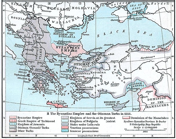
English: Map of the Byzantine, Ottoman and Serbian empires and their neighboring states, 1355. |
||||||||||||||||||||||
| תאריך יצירה | |||||||||||||||||||||||
| מקור | William R. Shepherd's Historical Atlas, p. 89, published by Henry Holt and Company, New York 1911 | ||||||||||||||||||||||
| יוצר |
|
||||||||||||||||||||||
| גרסאות אחרות |
|
||||||||||||||||||||||

רישיון[עריכה]
This work is in the public domain in the United States because it was published (or registered with the U.S. Copyright Office) before January 1, 1929.
Public domain works must be out of copyright in both the United States and in the source country of the work in order to be hosted on the Commons. If the work is not a U.S. work, the file must have an additional copyright tag indicating the copyright status in the source country.
Note: This tag should not be used for sound recordings. |
היסטוריית הקובץ
ניתן ללחוץ על תאריך/שעה כדי לראות את הקובץ כפי שנראה באותו זמן.
| תאריך/שעה | תמונה ממוזערת | ממדים | משתמש | הערה | |
|---|---|---|---|---|---|
| נוכחית | 20:53, 6 בדצמבר 2022 | | 897 × 1,134 (380 ק"ב) | Gyalu22 (שיחה | תרומות) | Artwork |
| 16:44, 29 במרץ 2018 |  | 879 × 1,112 (908 ק"ב) | Nihil scimus (שיחה | תרומות) | Few improving (esthetic, contrast, genoese possessions 1355 since Westermann Grosser Atlas zur Weltgeschichte, 1985, ISBN 3-14-100919-8, p. 70, wallachian possessions 1355 under Nicholas Alexander [https://commons.wikimedia.org/wiki/File:Nicolae_Alexandru.jpg] since [https://en.wikipedia.org/wiki/Wallachia#/media/File:Wallachia_13-16c.svg]). | |
| 13:17, 8 בנובמבר 2009 |  | 897 × 1,134 (380 ק"ב) | Alex:D (שיחה | תרומות) | whitened | |
| 16:00, 3 בדצמבר 2005 |  | 897 × 1,134 (269 ק"ב) | Migdejong (שיחה | תרומות) | Map of the Byzantine Empire in the year 1355. Image comes from the University of Texas at Austin: http://geography.about.com/gi/dynamic/offsite.htm?site=http://www.lib.utexas.edu/maps/historical/history%5Feurope.html Map is released into the public |
אין באפשרותך לדרוס את הקובץ הזה.
שימוש בקובץ
הדפים הבאים משתמשים בקובץ הזה:
- Atlas of Albania
- Atlas of Bosnia and Herzegovina
- Atlas of Cyprus
- Atlas of Greece
- Atlas of Kosovo
- Atlas of Montenegro
- Atlas of North Macedonia
- Atlas of Northern Cyprus
- Atlas of Republika Srpska
- Atlas of Serbia
- Atlas of Turkey
- Atlas of ancient Rome
- Atlas of the Byzantine Empire
- Byzantine Empire
- User:J budissin/Uploads/BiH/2018 March 21-31
- File:Byzantine Empire 1355.jpg
- File:Serbian Empire 1355-cs.png
שימוש גלובלי בקובץ
אתרי הוויקי השונים הבאים משתמשים בקובץ זה:
- שימוש באתר ar.wikipedia.org
- שימוש באתר azb.wikipedia.org
- שימוש באתר az.wikipedia.org
- שימוש באתר ba.wikipedia.org
- שימוש באתר bg.wikipedia.org
- שימוש באתר bs.wikipedia.org
- שימוש באתר ca.wikipedia.org
- שימוש באתר de.wikipedia.org
- Byzantinisches Reich
- Makedonien
- 1355
- Großserbien
- Marino Falier
- Andronikos IV.
- Beylik von Aydın
- Eroberung von Philadelphia
- Eroberung von Gallipoli
- Byzantinisch-genuesischer Krieg (1348–1349)
- Byzantinischer Bürgerkrieg (1352–1357)
- Byzantinischer Bürgerkrieg (1373–1381)
- Kreuzzug von Smyrna
- Benutzer:GerardM/Battles including the Ottoman Empire
- שימוש באתר el.wikipedia.org
- שימוש באתר en.wikipedia.org
צפייה בשימושים גלובליים נוספים של קובץ זה.
מטא־נתונים
קטגוריות:
- Old maps of the Byzantine Empire
- Maps showing history by William R. Shepherd
- William R. Shepherd
- Maps of the history of the medieval Balkans
- Maps of the Serbian Empire
- Maps of the history of North Macedonia in the Middle Ages
- Maps of 14th-century Bulgaria
- Maps of the history of Romania in the Middle Ages
- Maps showing 1355
- Maps of 14th-century Serbia
- Maps of the Ottoman Empire in the 14th century