File:Cantacuzino Wallachia.png
Jump to navigation
Jump to search
Size of this preview: 800 × 415 pixels. Other resolutions: 320 × 166 pixels | 640 × 332 pixels | 1,024 × 531 pixels | 1,280 × 663 pixels | 2,560 × 1,327 pixels | 4,014 × 2,080 pixels.
Original file (4,014 × 2,080 pixels, file size: 15.42 MB, MIME type: image/png)
Captions
Captions
Add a one-line explanation of what this file represents
Summary[edit]
| Description |
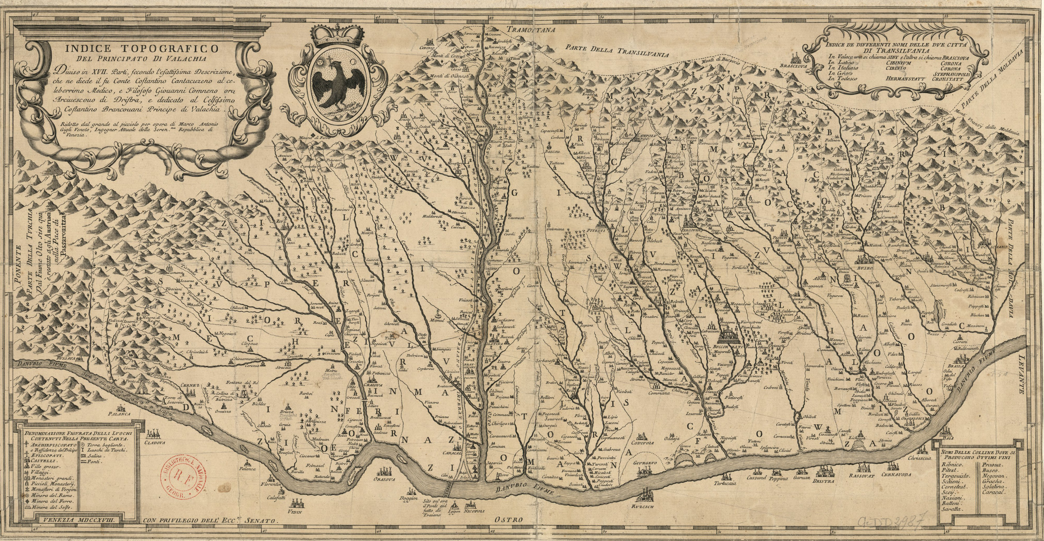
English: 17th century map of Wallachia (nowadays, Southern Romania), by stolnic Constantin Cantacuzino Italiano: Indice topografico del principato di Valachia diviso in XVII parti, secondo l'esttissima descrizione, che ne diede il su conte costantino cantacuzeno al celeberrimo medico, e filosofo Giovanni Commeno ora archivescovo di Dnistra / opera di Marco Antonio Gigli Veneto Română: Hartă a Ţării Româneşti din secolul al XVIII-lea, de stolnicul Constantin Cantacuzino |
| Date | late 17th century - early 18th century |
| Source | Bibliothèque nationale de France, département Cartes et plans, CPL GE DD-2987 (5946 B) |
| Author | stolnic Constantin Cantacuzino (d. 1716) |
| Other versions | Derivative works of this file: Cantacuzino Sacueni.png |
Licensing[edit]
|
This work is in the public domain in its country of origin and other countries and areas where the copyright term is the author's life plus 100 years or fewer. | |
| This file has been identified as being free of known restrictions under copyright law, including all related and neighboring rights. | |
File history
Click on a date/time to view the file as it appeared at that time.
| Date/Time | Thumbnail | Dimensions | User | Comment | |
|---|---|---|---|---|---|
| current | 13:03, 14 September 2011 | | 4,014 × 2,080 (15.42 MB) | Andrei Stroe (talk | contribs) |
You cannot overwrite this file.
File usage on Commons
The following page uses this file:
File usage on other wikis
The following other wikis use this file:
- Usage on bg.wikipedia.org
- Usage on ca.wikipedia.org
- Usage on el.wikipedia.org
- Usage on en.wikipedia.org
- Usage on es.wikipedia.org
- Usage on et.wikipedia.org
- Usage on it.wikipedia.org
- Usage on mk.wikipedia.org
- Usage on ro.wikipedia.org
- Usage on ru.wikipedia.org
- Usage on sl.wikipedia.org