File:Chacaltaya Pano MC.jpg
Bước tới điều hướng
Bước tới tìm kiếm

Kích thước hình xem trước: 800×258 điểm ảnh. Độ phân giải khác: 320×103 điểm ảnh | 640×207 điểm ảnh | 1.024×330 điểm ảnh | 1.280×413 điểm ảnh | 2.560×826 điểm ảnh | 10.000×3.227 điểm ảnh.
Tập tin gốc (10.000×3.227 điểm ảnh, kích thước tập tin: 12,42 MB, kiểu MIME: image/jpeg)
Chú thích
Chú thích
Ghi một dòng giải thích những gì có trong tập tin này
|

Miêu tả[sửa]
| Miêu tả |
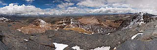
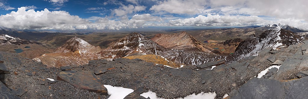
English: A panoramic view from the top of Chacaltaya (5421m). In the background you can see the cities of La Paz and El Alto (distance about 15km), as well as Lake Titicaca (distance about 50km). Panorama stitched from 16 portrait format images. The camera was rotated using a Nodal Ninja [1] nodal point adapter which was mounted on a tripod. All photos were taken with the same exposure settings in RAW format and developed with exactly the same settings in a RAW converter. For stitching PTGUI [2] was used.
Deutsch: Panorama vom Gipfel des Chacaltaya (5421 m). Im Hintergrund sieht man die Städte La Paz und El Alto (Entfernung etwa 15 km) sowie den Titicacasee (Entfernung etwa 50 km). Panorama zusammengesetzt aus 16 Hochformatbildern. Die Kamera wurde mit Hilfe eines Nodal Ninja [3] Nodalpunktadapters (der auf einem Stativ befestigt war) rotiert. Alle Fotos wurden mit denselben Belichtungseinstellungen im RAW-Format aufgezeichnet und mit denselben Einstellungen in einem RAW-Konverter entwickelt. Zum Zusammenfügen wurde PTGUI [4] verwendet.
Français : Vue panoramique prise du sommet du Chacaltaya (5421m). A l'arrière-plan, on peut discerner les villes de La Paz et El Alto (distance d'environ 15km), aussi bien que le lac Titicaca (distance d'environ 50km). Panorama ubtenu par la fusion de 16 images au format portrait. L'appareil photo a été mis en rotation avec un adaptateur Nodal Ninja [5] monté sur trépied. Toutes les photos ont été prises avec la même exposition en format RAW et développées avec les mêmes réglages. La fusion a été réalisée avec PTGUI [6]. |
| Ngày | |
| Nguồn gốc | Tác phẩm được tạo bởi người tải lên |
| Tác giả | Christian Mehlführer, User:Chmehl |
| Vị trí máy chụp hình | | Xem hình này và các hình ảnh lân cận trên: OpenStreetMap |
|---|
Giấy phép[sửa]
Tôi, người giữ bản quyền tác phẩm này, từ đây phát hành nó theo giấy phép sau:
Tập tin này được phát hành theo Giấy phép Creative Commons Ghi công 3.0 Chưa chuyển đổi
- Bạn được phép:
- chia sẻ – sao chép, phân phối và chuyển giao tác phẩm
- pha trộn – để chuyển thể tác phẩm
- Theo các điều kiện sau:
- ghi công – Bạn phải ghi lại tác giả và nguồn, liên kết đến giấy phép, và các thay đổi đã được thực hiện, nếu có. Bạn có thể làm các điều trên bằng bất kỳ cách hợp lý nào, miễn sao không ám chỉ rằng người cho giấy phép ủng hộ bạn hay việc sử dụng của bạn.
Lịch sử tập tin
Nhấn vào ngày/giờ để xem nội dung tập tin tại thời điểm đó.
| Ngày/Giờ | Hình xem trước | Kích cỡ | Thành viên | Miêu tả | |
|---|---|---|---|---|---|
| hiện tại | 20:57, ngày 15 tháng 4 năm 2009 | 10.000×3.227 (12,42 MB) | Chmehl (thảo luận | đóng góp) | straightened panorama and corrected tilt | |
| 19:37, ngày 15 tháng 4 năm 2009 | 9.000×2.931 (10,5 MB) | Chmehl (thảo luận | đóng góp) | straightened panorama and corrected tilt | ||
| 15:28, ngày 13 tháng 4 năm 2009 | 9.000×2.838 (10,98 MB) | Chmehl (thảo luận | đóng góp) | {{Information |Description={{en|1=A panoramic view from the top of Chacaltaya (5421m). In the background you can see the cities of La Paz and El Alto (distance about 15km), as well as [[:en:Lake_Titicaca|L |
Bạn không được phép ghi đè tập tin này.
Trang sử dụng tập tin
27 trang sau sử dụng tập tin này:
- User:Chmehl
- User talk:99of9/Promotions
- User talk:Chmehl
- Commons:Commons Monthly
- Commons:Featured picture candidates/File:Chacaltaya Pano MC.jpg
- Commons:Featured picture candidates/Log/February 2010
- Commons:Featured pictures/Places/Natural
- Commons:Featured pictures/Places/Panoramas
- Commons:Featured pictures/chronological/2010-A
- Commons:Picture of the Year/2010/Galleries/2010-A
- Commons:Picture of the Year/2010/Galleries/All
- Commons:Picture of the Year/2010/Galleries/Index/2
- Commons:Picture of the Year/2010/Galleries/Index/Panoramas
- Commons:Picture of the Year/2010/Galleries/Panoramas
- Commons:Picture of the Year/2010/Galleries/Panoramas/Large
- Commons:Picture of the Year/2010/Galleries/Panoramas/Small
- Commons:Picture of the Year/2010/Galleries/Table
- Commons:Picture of the Year/2010/Galleries/Table/02
- Commons:Picture of the Year/2010/R1/File:Chacaltaya Pano MC.jpg
- Commons:Picture of the Year/2010/Results/R1/ALL/Table
- Commons:Picture of the Year/2010/Results/R1/Panoramas
- Commons:Picture of the Year/2010/Results/R1/Panoramas/Table
- Commons:Quality images/Subject/Places/Natural structures/Panorama/Archive 2008 to 2015
- Commons:Quality images candidates/Archives April 2009
- Commons talk:Picture of the Year/2010/Galleries/Table
- Commons talk:Picture of the Year/2010/Results/R1/ALL/Table
- File:Chacaltaya banner.jpg
Sử dụng tập tin toàn cục
Những wiki sau đang sử dụng tập tin này:
- Trang sử dụng tại es.wikipedia.org
- Trang sử dụng tại fa.wikipedia.org
- Trang sử dụng tại fr.wikipedia.org
- Trang sử dụng tại ha.wikipedia.org
- Trang sử dụng tại id.wikipedia.org
- Trang sử dụng tại krc.wikipedia.org
- Trang sử dụng tại pl.wikipedia.org
- Trang sử dụng tại tr.wikipedia.org
- Vikipedi:Seçkin resimler/Mekânlar/Panorama
- Chacaltaya
- Vikipedi:Seçkin resim adayları/Chacaltaya Pano MC.jpg
- Vikipedi:Seçkin resim adayları/Arşiv/Şubat 2010
- Vikipedi:Günün seçkin resmi/Ağustos 2011
- Şablon:GSR/2011-08-03
- Vikipedi:Seçkin resimler/Ana sayfaya çıkmış resimler/2011 listesi
- Vikipedi:Seçkin resimler/Ana sayfaya çıkmış resimler/2014 listesi
- Vikipedi:Günün seçkin resmi/Aralık 2014
- Şablon:GSR/2014-12-05
- Şablon:GSR/2017-05-11
- Vikipedi:Günün seçkin resmi/Mayıs 2017
- Trang sử dụng tại vi.wikipedia.org