File:Chicxulub radar topography.jpg
Bước tới điều hướng
Bước tới tìm kiếm
Kích thước hình xem trước: 536×599 điểm ảnh. Độ phân giải khác: 215×240 điểm ảnh | 429×480 điểm ảnh | 715×799 điểm ảnh.
Tập tin gốc (715×799 điểm ảnh, kích thước tập tin: 119 kB, kiểu MIME: image/jpeg)
Chú thích
Chú thích
Ghi một dòng giải thích những gì có trong tập tin này
Miêu tả
[sửa]
| Miêu tả |
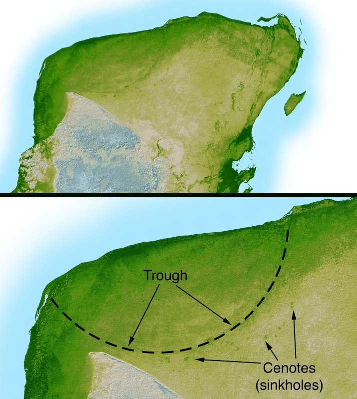
English: This shaded relief image of Mexico's Yucatan Peninsula show a subtle, but unmistakable, indication of the Chicxulub impact crater. Most scientists now agree that this impact was the cause of the Cretatious-Tertiary Extinction, the event approximately 66 million years ago that marked the sudden extinction of the dinosaurs as well as the majority of life then on Earth. |
| Ngày | |
| Nguồn gốc | http://photojournal.jpl.nasa.gov/catalog/PIA03379 |
| Tác giả | NASA/JPL-Caltech |
| Phiên bản khác | version with more labels and scale indicators |
This image or video was catalogued by Jet Propulsion Laboratory of the United States National Aeronautics and Space Administration (NASA) under Photo ID: PIA03379. This tag does not indicate the copyright status of the attached work. A normal copyright tag is still required. See Commons:Licensing. Other languages:
|
Giấy phép
[sửa]
| This file is in the public domain in the United States because it was solely created by NASA. NASA copyright policy states that "NASA material is not protected by copyright unless noted". (See Template:PD-USGov, NASA copyright policy page or JPL Image Use Policy.) | ||
 |
Warnings:
|
Lịch sử tập tin
Nhấn vào ngày/giờ để xem nội dung tập tin tại thời điểm đó.
| Ngày/Giờ | Hình xem trước | Kích cỡ | Thành viên | Miêu tả | |
|---|---|---|---|---|---|
| hiện tại | 04:38, ngày 11 tháng 9 năm 2005 | | 715×799 (119 kB) | Miya (thảo luận | đóng góp) | This image is originally uploaded to English Wikipedia with the informaion as follows: [[{{PD}}Radar topography]] (color corresponds to height) of the [[{{PD}}Yucatán]] peninsula, revealing the en:Chicxulub Crater. Courtesy NASA/JPL-Caltech (it is |
Bạn không được phép ghi đè tập tin này.
Trang sử dụng tập tin
Trang sau sử dụng tập tin này:
Sử dụng tập tin toàn cục
Những wiki sau đang sử dụng tập tin này:
- Trang sử dụng tại ar.wikipedia.org
- Trang sử dụng tại ast.wikipedia.org
- Trang sử dụng tại br.wikipedia.org
- Trang sử dụng tại ca.wikipedia.org
- Trang sử dụng tại da.wikipedia.org
- Trang sử dụng tại en.wikipedia.org
- Trang sử dụng tại es.wikipedia.org
- Trang sử dụng tại fr.wikipedia.org
- Trang sử dụng tại hu.wikipedia.org
- Trang sử dụng tại it.wikipedia.org
- Trang sử dụng tại ja.wikipedia.org
- Trang sử dụng tại lt.wikipedia.org
- Trang sử dụng tại lv.wikipedia.org
- Trang sử dụng tại mk.wikipedia.org
- Trang sử dụng tại nl.wikipedia.org
- Trang sử dụng tại oc.wikipedia.org
- Trang sử dụng tại pl.wikipedia.org
- Trang sử dụng tại pt.wikipedia.org
- Trang sử dụng tại su.wikipedia.org
- Trang sử dụng tại te.wikipedia.org
- Trang sử dụng tại vi.wikipedia.org
- Trang sử dụng tại zh.wikipedia.org