File:Cilician Armenia-en.svg
둘러보기로 이동
검색으로 이동

SVG 파일의 PNG 형식의 미리보기 크기: 800 × 571 픽셀. 다른 해상도: 320 × 228 픽셀 | 640 × 457 픽셀 | 1,024 × 730 픽셀 | 1,280 × 913 픽셀 | 2,560 × 1,826 픽셀 | 2,508 × 1,789 픽셀
원본 파일 (SVG 파일, 실제 크기 2,508 × 1,789 픽셀, 파일 크기: 713 KB)
캡션
설명
이 파일이 나타내는 바에 대한 한 줄 설명을 추가합니다
파일 설명
[편집]| 묘사 |
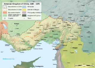
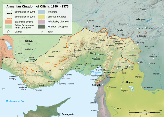
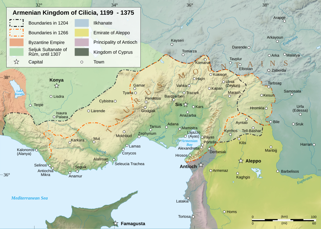
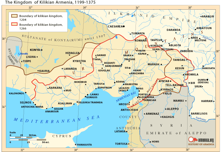
Čeština: Mapa Arménského království v Kilíkii v 13. století. Deutsch: Karte des Armenischen Königreichs von Kilikien während des 13. Jahrhunderts. English: Map of the Armenian Kingdom of Cilicia during the XIII century. Español: Mapa del siglo XIII del Reino armenio de Cilicia. Esperanto: Mapo de la Armena reĝlando en Kilikio dum la 13-a jarcento. Français : Carte en anglais du royaume de Petite Arménie (en Cilicie) au XIIIe siècle. Italiano: Mappa topografica del regno armeno di Cilicia durante il XIII secolo. Kapampangan: Metung a mapa ning Kaariang Armenian ning Cilicia aniang ka-XIII a dilanua o siglu. Magyar: A Kilikiai Örmény Királyság 13. századi állapotát mutató térkép. Nederlands: Engelstalige kaart van Cilicisch Armenië in de 13e eeuw. Polski: Mapa Armenii Małej w XIII wieku. Português: Mapa do Reino Armênio da Cilícia no século XIII. Svenska: En karta över det armeniska kungariket Kilikien under 1200-talet. Türkçe: 13. yüzyılda Kilikya Ermeni Krallığı'nın sınırları. Беларуская: Карта Кілійскага армянскага царства (13 ст.) Македонски: Карта на Ерменското кралство Киликија во XIII век. Հայերեն : Կիլիկիայի Հայկական Թագավորության քարտեզը 13րդ դարում. বাংলা : ত্রয়োদশ শতকের সিলিসিয়ার আর্মেনীয় রাজত্বের মানচিত্র। 한국어: 13세기 킬리키아 아르메니아 왕국의 지도 日本語: 13世紀のキリキア・アルメニア王国の地図。 中文(简体): 奇里乞亚亚美尼亚王国13世纪地图 中文(繁體): 奇里乞亞亞美尼亞王國13世紀地圖 العربية : خريطة لمملكة قيليقية الأرمينية خلال القرن الثالث عشر مازِرونی : نخشه پادشائی کلیسائ ارمنی قرن |
||||||||
| 날짜 | |||||||||
| 출처 |
자작. English: Sources :
Software used :
Other data :
Français : Sources :
Logiciels utilisés :
Autres données :
|
||||||||
| 창작자 | |||||||||
| 지리 참고 | 부적절한 경우에 숨기려면 warp_status = skip로 설정하세요. | ||||||||
| 다른 버전 |
[]
| ||||||||
| 저작자표시 (required by the license) | © Sémhur / Wikimedia Commons / | ||||||||
| Assessments |
|
||||||||
| SVG |
|
||||||||
| Graphic Lab |


| 카메라 위치 | | 이 지역의 다른 사진을 보기: OpenStreetMap |
|---|
라이선스
[편집]
나는 아래 작품의 저작권자로서, 이 저작물을 다음과 같은 라이선스로 배포합니다:
| 카피레프트: 이 예술 작품은 프리 아트 라이선스의 조건에 따라 자유롭게 사용, 재배포, 수정할 수 있습니다.
라이선스 규약은 Copyleft Attitude 사이트, 혹은 다른 사이트에서 볼 수 있습니다. |
- 이용자는 다음의 권리를 갖습니다:
- 공유 및 이용 – 저작물의 복제, 배포, 전시, 공연 및 공중송신
- 재창작 – 저작물의 개작, 수정, 2차적저작물 창작
- 다음과 같은 조건을 따라야 합니다:
- 저작자표시 – 적절한 저작자 표시를 제공하고, 라이센스에 대한 링크를 제공하고, 변경사항이 있는지를 표시해야 합니다. 당신은 합리적인 방식으로 표시할 수 있지만, 어떤 방식으로든 사용권 허가자가 당신 또는 당신의 사용을 지지하는 방식으로 표시할 수 없습니다.
- 동일조건변경허락 – 만약 당신이 이 저작물을 리믹스 또는 변형하거나 이 저작물을 기반으로 제작하는 경우, 당신은 당신의 기여물을 원저작물과 동일하거나 호환 가능한 라이선스에 따라 배포하여야 합니다.
이 라이선스 중에서 목적에 맞는 것을 선택하여 사용할 수 있습니다.
나는 아래 작품의 저작권자로서, 이 저작물을 다음과 같은 라이선스로 배포합니다:

|
GNU 자유 문서 사용 허가서 1.2판 또는 자유 소프트웨어 재단에서 발행한 이후 판의 규정에 따라 본 문서를 복제하거나 개작 및 배포할 수 있습니다. 본 문서에는 변경 불가 부분이 없으며, 앞 표지 구절과 뒷 표지 구절도 없습니다. 본 사용 허가서의 전체 내용은 GNU 자유 문서 사용 허가서 부분에 포함되어 있습니다. |
| 이 파일은 크리에이티브 커먼즈 저작자표시-동일조건변경허락 3.0 Unported 라이선스로 배포됩니다. | ||
| ||
| 이 라이선스 틀은 GFDL 라이선스 변경의 일부로 이 파일에 추가되었습니다. |
파일 역사
날짜/시간 링크를 클릭하면 해당 시간의 파일을 볼 수 있습니다.
| 날짜/시간 | 섬네일 | 크기 | 사용자 | 설명 | |
|---|---|---|---|---|---|
| 현재 | 2023년 3월월 9일 (목) 19:23 | | 2,508 × 1,789 (713 KB) | Ömer faruk çakmak (토론 | 기여) | File uploaded using svgtranslate tool (https://svgtranslate.toolforge.org/). Added translation for tr. |
| 2023년 3월월 9일 (목) 18:29 |  | 2,508 × 1,789 (691 KB) | Ömer faruk çakmak (토론 | 기여) | File uploaded using svgtranslate tool (https://svgtranslate.toolforge.org/). Added translation for tr. | |
| 2008년 1월월 17일 (목) 10:58 |  | 2,508 × 1,789 (671 KB) | Sémhur (토론 | 기여) | Correcting few bugs (x2) | |
| 2008년 1월월 17일 (목) 10:55 |  | 2,508 × 1,789 (671 KB) | Sémhur (토론 | 기여) | Correcting few bugs | |
| 2008년 1월월 16일 (수) 19:42 |  | 2,508 × 1,789 (671 KB) | Sémhur (토론 | 기여) | heavier... Too bad | |
| 2008년 1월월 16일 (수) 19:33 |  | 2,508 × 1,789 (261 KB) | Sémhur (토론 | 기여) | bigger size, lighter weight, + coordinates | |
| 2008년 1월월 13일 (일) 11:38 |  | 1,458 × 991 (362 KB) | Sémhur (토론 | 기여) | == Description == {{Information |Description= {{en| Map of the Armenian Kingdom of Cilicia during the XIII century.}} {{fr| Carte en anglais du royaume de Petite Arménie (en Cilicie) au XIII<sup>ème</sup> siècle.}} |S |
이 파일을 덮어쓸 수 없습니다.
이 파일을 사용하는 문서
다음 문서 62개가 이 파일을 사용하고 있습니다:
- Atlas of Armenia
- Atlas of Turkey
- Atlas of the Levant
- User:Magog the Ogre/Multilingual legend/2023 March 1-10
- User:Miya/POTY/Diagrams2008
- User:Notafish/Votes 2008
- User:Sémhur
- User talk:Sting/Archive 01
- Commons:Featured picture candidates/Image:Cilician Armenia-en.svg
- Commons:Featured picture candidates/Log/January 2008
- Commons:Featured pictures/Non-photographic media/Maps
- Commons:Featured pictures/chronological/2008-A
- Commons:Picture of the Year/2008/Galleries/All
- Commons:Picture of the Year/2008/Galleries/Diagrams
- Commons:Picture of the Year/2008/Results/Round 1/Gallery/All
- Commons:Picture of the Year/2008/Results/Round 1/Gallery/Diagrams
- Commons:Picture of the Year 2008/File:Cilician Armenia-en.svg
- Commons:Potd/2010-03 (da)
- Commons:Potd/2010-03 (de)
- Commons:Potd/2010-03 (nl)
- Commons:Potd/2010-03 (pt)
- File:Armenianmeds.gif
- File:Cilician Armenia-ar.svg
- File:Cilician Armenia-cs.svg
- File:Cilician Armenia-en.svg
- File:Cilician Armenia-fr.svg
- File:Cilician Armenia-hu.svg
- File:Cilician Armenia-it.svg
- File:Cilician Armenia-sv.svg
- Template:Other versions/Cilician Armenia
- Template:Potd/2010-03
- Template:Potd/2010-03-04
- Template:Potd/2010-03-04 (ar)
- Template:Potd/2010-03-04 (be)
- Template:Potd/2010-03-04 (bn)
- Template:Potd/2010-03-04 (ca)
- Template:Potd/2010-03-04 (cs)
- Template:Potd/2010-03-04 (da)
- Template:Potd/2010-03-04 (de)
- Template:Potd/2010-03-04 (en)
- Template:Potd/2010-03-04 (eo)
- Template:Potd/2010-03-04 (es)
- Template:Potd/2010-03-04 (fr)
- Template:Potd/2010-03-04 (hu)
- Template:Potd/2010-03-04 (hy)
- Template:Potd/2010-03-04 (it)
- Template:Potd/2010-03-04 (ja)
- Template:Potd/2010-03-04 (ko)
- Template:Potd/2010-03-04 (mk)
- Template:Potd/2010-03-04 (mzn)
- Template:Potd/2010-03-04 (nl)
- Template:Potd/2010-03-04 (pam)
- Template:Potd/2010-03-04 (pl)
- Template:Potd/2010-03-04 (pt)
- Template:Potd/2010-03-04 (ru)
- Template:Potd/2010-03-04 (sv)
- Template:Potd/2010-03-04 (uk)
- Template:Potd/2010-03-04 (zh-hans)
- Template:Potd/2010-03-04 (zh-hant)
- Template:Potd/2010-03 (zh-hans)
- Category:Armenian Kingdom of Cilicia
- Category:Armenian Kings of Cilicia
이 파일을 사용하고 있는 모든 위키의 문서 목록
다음 위키에서 이 파일을 사용하고 있습니다:
- als.wikipedia.org에서 이 파일을 사용하고 있는 문서 목록
- an.wikipedia.org에서 이 파일을 사용하고 있는 문서 목록
- arz.wikipedia.org에서 이 파일을 사용하고 있는 문서 목록
- ast.wikipedia.org에서 이 파일을 사용하고 있는 문서 목록
- azb.wikipedia.org에서 이 파일을 사용하고 있는 문서 목록
- az.wikipedia.org에서 이 파일을 사용하고 있는 문서 목록
- ba.wikipedia.org에서 이 파일을 사용하고 있는 문서 목록
- be.wikipedia.org에서 이 파일을 사용하고 있는 문서 목록
- bg.wikipedia.org에서 이 파일을 사용하고 있는 문서 목록
- bn.wikipedia.org에서 이 파일을 사용하고 있는 문서 목록
- ca.wikipedia.org에서 이 파일을 사용하고 있는 문서 목록
- crh.wikipedia.org에서 이 파일을 사용하고 있는 문서 목록
- cs.wikipedia.org에서 이 파일을 사용하고 있는 문서 목록
- cv.wikipedia.org에서 이 파일을 사용하고 있는 문서 목록
- de.wikipedia.org에서 이 파일을 사용하고 있는 문서 목록
- el.wikipedia.org에서 이 파일을 사용하고 있는 문서 목록
- en.wikipedia.org에서 이 파일을 사용하고 있는 문서 목록
- Cilicia
- History of Armenia
- List of monarchs of the Armenian Kingdom of Cilicia
- Hethum II
- Leo I, King of Armenia
- Rumkale
- Armenian Kingdom of Cilicia
- Toros Roslin
- Armenian illuminated manuscripts
- Portal:Maps/Maps/Political
- Portal:Maps/Maps/Political/12
- Second Battle of Sarvandik'ar
- Wikipedia:Wikipedia Signpost/2012-04-30/WikiProject report
- Wikipedia:Wikipedia Signpost/Single/2012-04-30
- Wikipedia:Featured picture candidates/May-2013
- Wikipedia:Featured picture candidates/Cilician Armenia
- History of Cilicia
- Talk:Armenia/Archive 9
- Zayn al-Din Qaraja
- Ghars al-Din Khalil
- Ibrahim I of Ramadan
- User:Falcaorib/Medieval Empires (1300-1500 AD)
이 파일의 더 많은 사용 내역을 봅니다.
메타데이터
범주:
- Maps of Cilicia
- Maps of the Armenian Kingdom of Cilicia
- SVG maps of the history of Armenia
- Maps of the history of Turkey
- Maps of the history of Syria
- Maps showing 12th-century history
- Maps showing 13th-century history
- Maps showing 14th-century history
- Topographic maps of the Middle East
- English-language SVG maps showing history