File:Contiguous US physiographic divisions.png
Vai alla navigazione
Vai alla ricerca
Dimensioni di questa anteprima: 800 × 525 pixel. Altre risoluzioni: 320 × 210 pixel | 640 × 420 pixel | 1 024 × 672 pixel | 1 264 × 830 pixel.
File originale (1 264 × 830 pixel, dimensione del file: 1,1 MB, tipo MIME: image/png)
Didascalie
Didascalie
Aggiungi una brevissima spiegazione di ciò che questo file rappresenta
Dettagli
[modifica]| Descrizione |
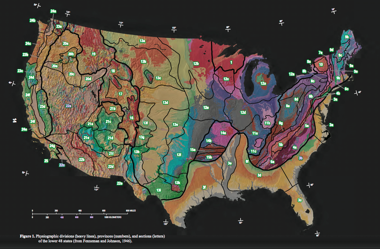
PHYSIOGRAPHIC REGIONS OF THE LOWER 48 UNITED STATES after Fenneman (1928) LAURENTIAN UPLAND 1. Superior Upland ATLANTIC PLAIN 2. Continental Shelf (not on map)
3. Coastal Plain
a. Embayed section
b. Sea Island section
c. Floridian section
d. East Gulf Coastal Plain
e. Mississippi Alluvial Plain
f. West Gulf Coastal Plain
APPALACHIAN HIGHLANDS 4. Piedmont province
a. Piedmont Upland
b. Piedmont Lowlands
5. Blue Ridge province
a. Northern section
b. Southern section
6. Valley and Ridge province
a. Tennessee section
b. Middle section
c. Hudson Valley
7. St. Lawrence Valley
a. Champlain section
b. Northern section (not on map)
8. Appalachian Plateaus province
a. Mohawk section
b. Catskill section
c. Southern New York section
d. Allegheny Mountain section
e. Kanawha section
f. Cumberland Plateau section
g. Cumberland Mountain section
9. New England Province
a. Seaboard Lowland section
b. New England Upland section
c. White Mountain section
d. Green Mountain section
e. Taconic section
10. Adirondack province
INTERIOR PLAINS 11. Interior Low Plateaus
a. Highland Rim section
b. Lexington Plain
c. Nashville Basin
12. Central Lowland
a. Eastern Lake section
b. Western Lake section
c. Wisconsin Driftless section
d. Till Plains
e. Dissected Till Plains
f. Osage Plains
13. Great Plains province
a. Missouri Plateau, glaciated
b. Missouri Plateau, unglaciated
c. Black Hills
d. High Plains
e. Plains Border
f. Colorado Piedmont
g. Raton section
h. Pecos Valley
i. Edwards Plateau
k. Central Texas section
INTERIOR HIGHLANDS 14. Ozark Plateaus
a. Springfield-Salem plateaus
b. Boston “Mountains”
15. Ouachita province
a. Arkansas Valley
b. Ouachita Mountains
ROCKY MOUNTAIN SYSTEM 16. Southern Rocky Mountains 17. Wyoming Basin 18. Middle Rocky Mountains 19. Northern Rocky Mountains INTERMONTANE PLATEAUS 20. Columbia Plateau
a. Walla Walla Plateau
b. Blue Mountain section
c. Payette section
d. Snake River Plain
e. Harney section
21. Colorado Plateaus
a. High Plateaus of Utah
b. Uinta Basin
c. Canyon Lands
d. Navajo section
e. Grand Canyon section
f. Datil section
22. Basin and Range province
a. Great Basin
b. Sonoran Desert
c. Salton Trough
d. Mexican Highland
e. Sacramento section
PACIFIC MOUNTAIN SYSTEM 23. Cascade-Sierra Mountains
a. Northern Cascade Mountains
b. Middle Cascade Mountains
c. Southern Cascade Mountains
d. Sierra Nevada
24. Pacific Border province
a. Puget Trough
b. Olympic Mountains
c. Oregon Coast Range
d. Klamath Mountains
e. California Trough
f. California Coast Ranges
g. Los Angeles Ranges
25. Lower California province |
| Data | |
| Fonte | A Tapestry of Time and Terrain: Pamphlet to accompany Geologic Investigations Series I–2720[1] |
| Autore | José F. Vigil, Richard J. Pike, and David G. Howell |
| Altre versioni |
|

Licenza
[modifica]
Quest'immagine è nel pubblico dominio perché contiene materiale proveniente dallo United States Geological Survey, un'agenzia del Dipartimento degli Interni degli Stati Uniti. Per maggiori informazioni vedere la politica ufficiale dell'USGS sul copyright.
|
Cronologia del file
Fare clic su un gruppo data/ora per vedere il file come si presentava nel momento indicato.
| Data/Ora | Miniatura | Dimensioni | Utente | Commento | |
|---|---|---|---|---|---|
| attuale | 03:25, 7 apr 2017 | | 1 264 × 830 (1,1 MB) | Wsiegmund (discussione | contributi) | Photoshop Elements 11: increased saturation, adjusted hue. |
| 02:46, 7 apr 2017 |  | 1 264 × 830 (1,17 MB) | Wsiegmund (discussione | contributi) | {{Information |Description=PHYSIOGRAPHIC REGIONS OF THE LOWER 48 UNITED STATES after Fenneman (1928)<br/> <br/> LAURENTIAN UPLAND <br/> 1. Superior Upland<br/> <br/> ATLANTIC PLAIN<br/> 2. Continental Shelf (not on map) <br/> 3. Coastal Plain<br/... |
Impossibile sovrascrivere questo file.
Utilizzo del file
La seguente pagina usa questo file:
Utilizzo globale del file
Anche i seguenti wiki usano questo file:
- Usato nelle seguenti pagine di en.wikipedia.org:
- Usato nelle seguenti pagine di it.wikipedia.org:
- Usato nelle seguenti pagine di simple.wikipedia.org:
- Usato nelle seguenti pagine di uk.wikipedia.org: