File:DFW Airport Diagram.svg
Bước tới điều hướng
Bước tới tìm kiếm

Kích thước bản xem trước PNG này của tập tin SVG: 378×548 điểm ảnh. Độ phân giải khác: 165×240 điểm ảnh | 331×480 điểm ảnh | 530×768 điểm ảnh | 706×1.024 điểm ảnh | 1.413×2.048 điểm ảnh.
Tập tin gốc (tập tin SVG, 378×548 điểm ảnh trên danh nghĩa, kích thước: 1,55 MB)
Chú thích
Chú thích
Ghi một dòng giải thích những gì có trong tập tin này
Miêu tả
[sửa]
| Miêu tả |
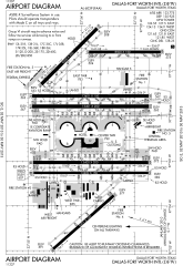
English: FAA Airport Diagram of Dallas-Fort Worth International Airport. |
| Ngày | |
| Nguồn gốc |
FAA Airport Diagrams; note that these change every 28 days. Taken from PDF on FAA site and converted to SVG using en:Wikipedia:How to draw SVG circuits using Xcircuit. |
| Tác giả | Produced by the National Aeronautical Charting Office (NACO), a department of the United States en:Federal Aviation Administration. |
| Vị trí máy chụp hình | | Xem hình này và các hình ảnh lân cận trên: OpenStreetMap |
|---|
W3C-validity not checked.
Giấy phép
[sửa]
This image or file is a work of a Federal Aviation Administration employee, taken or made as part of that person's official duties. As a work of the U.S. federal government, the image is in the public domain in the United States.
|
 |
Lịch sử tập tin
Nhấn vào ngày/giờ để xem nội dung tập tin tại thời điểm đó.
| Ngày/Giờ | Hình xem trước | Kích cỡ | Thành viên | Miêu tả | |
|---|---|---|---|---|---|
| hiện tại | 14:07, ngày 2 tháng 5 năm 2013 | | 378×548 (1,55 MB) | Grendelkhan (thảo luận | đóng góp) | SVG version of FAA's PDF diagram. |
Bạn không được phép ghi đè tập tin này.
Trang sử dụng tập tin
4 trang sau sử dụng tập tin này:
Sử dụng tập tin toàn cục
Những wiki sau đang sử dụng tập tin này:
- Trang sử dụng tại ar.wikipedia.org
- Trang sử dụng tại bn.wikipedia.org
- Trang sử dụng tại de.wikipedia.org
- Trang sử dụng tại en.wikipedia.org
- Trang sử dụng tại es.wikipedia.org
- Trang sử dụng tại fa.wikipedia.org
- Trang sử dụng tại fr.wikipedia.org
- Trang sử dụng tại he.wikipedia.org
- Trang sử dụng tại id.wikipedia.org
- Trang sử dụng tại ja.wikipedia.org
- Trang sử dụng tại ru.wikipedia.org
- Trang sử dụng tại simple.wikipedia.org
- Trang sử dụng tại ta.wikipedia.org
- Trang sử dụng tại th.wikipedia.org
- Trang sử dụng tại ur.wikipedia.org
- Trang sử dụng tại vi.wikipedia.org
- Trang sử dụng tại zh.wikipedia.org